TO
Filters: Collection: "ir_eua"
| Title | Date | Subject | Description | ||
|---|---|---|---|---|---|
| 101 |
 |
Oil-impregnated sandstone between Dirty Devil and Colorado and Green Rivers Garfield and Wayne Counties, Utah | 1969-02-26 | oil-impregnated sandstone; Utah sandstone; mineral resources inventory; Tar Sand Triangle | This paper presents the results of two months of field work done as a part of the Utah Geological Survey's continuing inventory of the mineral resources of the state of Utah. Prior to this field work. Survey field parties had worked in the area intermittently in 1967 and 1968 laying the ground work ... |
| 102 |
 |
Academic Resources | |||
| 103 |
 |
Academic Resources | |||
| 104 |
 |
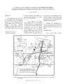
Economic potential of state-owned lands in the Sunnyside Special Tar Sand Area Carbon County, Utah | 1985 | The Sunnyside oil-impregnated (tar sand) deposit is located in the southwestern portion of the Uinta Basin, approximately 25 miles east of Price, Utah (fig. 1). The tar sands are located in the Wasatch Formation and in the Douglas Creek Member of the Green River Formation, with up to 32 individual b... | |
| 105 |
 |
Geology of Circle Cliffs Anticline | 1954 | geology; Circle Cliffs Anticline; stratigraphy; physiography | Circle Cliffs anticline occupies an area, approximately fifteen miles wide, which extends in a northnorthwest direction from Kane County on the south through east-central Garfield County to the Wayne County line. Its axis lies approximately 25 miles east of Boulder, Utah. Hall's Creek, located at th... |
| 106 |
 |
Oil impregnated carbonate rocks of the Timpoweap Member Moenkopi Formation, Hurricane Cliffs area, Utah and Arizona | 1979 | Oil impregnated rocks; Hurricane Cliffs; Utah; Arizona; Timpoweap Member; Triassic Moenkopi Formation; Timpoweap Canyon; Hurricane, Utah | Oil impregnated rocks crop out at several localities near the Hurricane Cliffs in southwestern Utah and adjacent Arizona. The most significant petroliferous deposits occur in the Timpoweap Member of the Triassic Moenkopi Formation in Timpoweap Canyon and the Hurricane Cliffs south of Hurricane, Utah... |
| 107 |
 |
Oil-impregnated sandstones of Raven Ridge, Vernal, Utah | 1972 | Oil-impregnated sandstone; Raven Ridge; Vernal, Utah; Uinta Basin; Utah; Colorado; Wasatch Formation; Green River Formation; Uinta Formation | The area of this report is in the northeastern part of the Uinta Basin of northeastern Utah and northwestern Colorado. The area covers approximately 52 square miles of what is regionally called Raven Ridge. Raven Ridge, a series of hogback ridges, trends northwest-southeast, and includes three Eocen... |
| 108 |
 |
Green River Formation at Raven Ridge, Uintah County, Utah | 1965-07 | Green River formation; Raven Ridge; sandstone beds; shale; limestone; marlstone; oil-bearing strata | Along Raven Ridge in Uintah County, Utah, exposures of the Green River Formation contain a complex sequence of intertonguing beds of sandstone, shale, limestone, and marlstone. These strata are considered to represent deposition in an orderly sequence of environments from the flood plain through the... |
| 109 |
 |
Research Agencies | |||
| 110 |
 |
Research Agencies | |||
| 111 |
 |
Research Agencies | |||
| 112 |
 |
AK_Libraries, Museums & Other Resources | |||
| 113 |
 |
Libraries, Museums & Other Resources | |||
| 114 |
 |
Oil shale: History, incentives, and policy | 2006-04-13 | oil shale; retorted oil shale yeilds; liquid hydrocarbons | Oil shale is prevalent in the western states of Colorado, Utah, and Wyoming. The resource potential of these shales is estimated to be the equivalent of 1.8 trillion barrels of oil in place. Retorted oil shale yields liquid hydrocarbons in the range of middle-distillate fuels, such as jet and diesel... |
| 115 |
 |
General Education Honors Program | |||
| 116 |
 |
Geologic influences on the in situ processing of tar sand at the northwest Asphalt Ridge deposit, Utah | 1985-01 | in situ oil recovery field experiments; oil recovery; tar sand; in situ tar sand processing; Asphalt Ridge deposit | The Laramie Energy Technology Center, Department of Energy, completed three in situ oil recovery field experiments, two combustion and one steamflood, in tar sand at Northwest Asphalt Ridge, Utah. Inadequate resource and site characterization prior to the field experiments contributed to process des... |
| 117 |
 |
Utah's oil-sand resources | 2006-09-21 | tar sands; tar sand; recoverable heavy oil; natural bitumen recovery; world wide tar sand resources. | Tar sands--a look around the world. Recovery factors and technically recoverable heavy oils and natural bitumens from around the globe. |
| 118 |
 |
Staff | |||
| 119 |
 |
UUSAC 1993-4, Bonnie M. McMorris Volume 1 | Staff advisory committee; Year end; University of Utah employees | Year end report of UUSAC activities, membership and other committee work. | |
| 120 |
 |
UUSAC correspondence 1993-1994 | 1994 | Letters | Letters and memos written by and to Bonnie McMorris concerning UUSAC business. |
| 121 |
 |
AK_Academic Resources | |||
| 122 |
 |
Libraries, Museums & Other Resources | Libraries; Museums; Higher education resources; University of Utah | The libraries, museum and other resources connected with the University of Utah. | |
| 123 |
 |
History of Special Collections, University of Utah Library | 1986 | J. Willard Marriott Library; Library Collections; University of Utah, history; University of Utah Libraries, Special Collections Department | This paper is an enlarged version of an address given to the Utah Library Association, April 9, 1986, Park City, Utah. |
| 124 |
 |
Trace metals in heavy crude oils and tar sand bitumens | 1990-11-28 | trace metals; heavy crude oils; tar sand bitumens; bulk metals levels; size behavior; ultra-trace metals | Fe, Ni, and V are considered trace impurities in heavy crude oils and tar sand bitumens. These metals are important in the petroleum industry, particularly because they are deleterious to petroleum upgrading catalysts and present potential biomarkers and diagenesis indicators. In order to understand... |
| 125 |
 |
Geologic summary report of the 1988 exploration program, Sunnyside Tar Sands project, Carbon County, Utah--volume 1 | 1989-06-01 | geologic summary report; exploration program; Sunnyside tar sands project; tar sand | The 1988 field program focused on completion and logging of twelve core drill holes and three measured sections. Five marker beds were established within the Parachute Creek Member and include the Wavy Bedded Tuff, Mahogany oil shale, R-5 oil shale, lower tuff and Blue Marker containing the R-2 oil ... |