Filters: Collection:"ir_eua"
| Title | Date | Subject | Description | ||
|---|---|---|---|---|---|
| 101 | 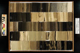 | Skyline 16: SW SW sec. 10 11S 25E Uintah County, Utah. Box 92 Depth: 930.0 - 940.0 ft. | 2015-07 | core sample; Skyline 16; box 92; Green River Formation | Core sample photograph by the Utah Geological Survey at the University of Utah, and the Utah Core Research Center. Skyline 16: SW SW sec. 10 11S 25E Uintah County, Utah. Box 92 Depth: 930.0 - 940.0 ft. |
| 102 | 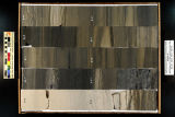 | Skyline 16: SW SW sec. 10 11S 25E Uintah County, Utah. Box 93 Depth: 940.0 - 950.0 ft. | 2015-07 | core sample; Skyline 16; box 93; Green River Formation | Core sample photograph by the Utah Geological Survey at the University of Utah, and the Utah Core Research Center. Skyline 16: SW SW sec. 10 11S 25E Uintah County, Utah. Box 93 Depth: 940.0 - 950.0 ft. |
| 103 | 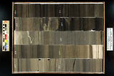 | Skyline 16: SW SW sec. 10 11S 25E Uintah County, Utah. Box 94 Depth: 950.0 - 960.0 ft. | 2015-07 | core sample; Skyline 16; box 94; Green River Formation | Core sample photograph by the Utah Geological Survey at the University of Utah, and the Utah Core Research Center. Skyline 16: SW SW sec. 10 11S 25E Uintah County, Utah. Box 94 Depth: 950.0 - 960.0 ft. |
| 104 | 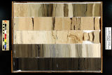 | Skyline 16: SW SW sec. 10 11S 25E Uintah County, Utah. Box 95 Depth: 960.0 - 970.0 ft. | 2015-07 | core sample; Skyline 16; box 95; Green River Formation | Core sample photograph by the Utah Geological Survey at the University of Utah, and the Utah Core Research Center. Skyline 16: SW SW sec. 10 11S 25E Uintah County, Utah. Box 95 Depth: 960.0 - 970.0 ft. |
| 105 | 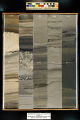 | Skyline 16: SW SW sec. 10 11S 25E Uintah County, Utah. Box 96 Depth: 970.0 - 980.0 ft. | 2015-07 | core sample; Skyline 16; box 96; Green River Formation | Core sample photograph by the Utah Geological Survey at the University of Utah, and the Utah Core Research Center. Skyline 16: SW SW sec. 10 11S 25E Uintah County, Utah. Box 96 Depth: 970.0 - 980.0 ft. |
| 106 |  | Skyline 16: SW SW sec. 10 11S 25E Uintah County, Utah. Box 97 Depth: 980.0 - 990.0 ft. | 2015-07 | core sample; Skyline 16; box 97; Green River Formation | Core sample photograph by the Utah Geological Survey at the University of Utah, and the Utah Core Research Center. Skyline 16: SW SW sec. 10 11S 25E Uintah County, Utah. Box 97 Depth: 980.0 - 990.0 ft. |
| 107 | 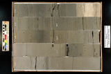 | Skyline 16: SW SW sec. 10 11S 25E Uintah County, Utah. Box 98 Depth: 990.0 - 1000.0 ft. | 2015-07 | core sample; Skyline 16; box 98; Green River Formation | Core sample photograph by the Utah Geological Survey at the University of Utah, and the Utah Core Research Center. Skyline 16: SW SW sec. 10 11S 25E Uintah County, Utah. Box 98 Depth: 990.0 - 1000.0 ft. |
| 108 | 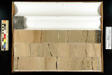 | Skyline 16: SW SW sec. 10 11S 25E Uintah County, Utah. Box 99 Depth: 1000.0 - 1006.25 ft. | 2015-07 | core sample; Skyline 16; Green River Formation; box 99 | Core sample photograph by the Utah Geological Survey at the University of Utah, and the Utah Core Research Center. Skyline 16: SW SW sec. 10 11S 25E Uintah County, Utah. Box 99 Depth: 1000.0 - 1006.25 ft. |
| 109 |  | Survey Plat Skyline 16 | 2015-07 | survey plat; Skyline 16; well survey | Survey plat of Skyline 16 well. |
| 110 |  | Underground coal thermal treatment - Task 6 topical report, Utah Clean Coal Program | 2015-01 | transformational energy production; insitu thermal treatment of a coal seam; coal reserves; underground coal thermal treatment; Utah Clean Coal Program; coal resources | The long-term objective of this task is to develop a transformational energy production technology by in situ thermal treatment of a coal seam for the production of substitute natural gas and/or liquid transportation fuels while leaving much of the coal's carbon in the ground. This process converts ... |
| 111 |  | University of Utah and Utah Geological Survey Green River coring project summary | 2015-07 | Green River coring project; Skyline 16; oil shale deposits; Green River Formation | The University of Utah's Institute for Clean and Secure Energy and the Utah Geological Survey teamed up to drill 1000 feet of 4-inch diameter core in the upper Green River Formation oil shale deposits in the eastern Uinta Basin, Utah. The purpose was to recover nearly the entire oil shale zone (Para... |
| 112 |  | Validation results for core-scale oil shale pyrolysis | 2015-02 | oil and natural gas technology; validation results; core-scale oil shale pyrolysis; in situ production of oil from oil shale; oil shale; pyrolysis of oil shale | This report summarizes a study of oil shale pyrolysis at various scales and the subsequent development a model for in situ production of oil from oil shale. Oil shale from the Mahogany zone of the Green River formation was used in all experiments. Pyrolysis experiments were conducted at four scales,... |