TO
Filters: Collection: "ir_eua"
| Title | Date | Subject | Description | ||
|---|---|---|---|---|---|
| 76 |
 |
Oil-impregnated sandstone deposits Circle Cliffs Uplift, Utah | 1981-04 | oil-impregnated sandstone; Utah deposits; Circle Cliffs Uplift; Triassic Moenkopi Formation; oil-impregnated sandstone resource | One of the major oil-impregnated sandstone deposits in the United States is present on the Circle Cliffs uplift in an unnamed sandstone unit in the middle portion of the Triassic Moenkopi Formation. The deposit occurs on the west and east flanks of the uplift and is separated by an irregular barren ... |
| 77 |
 |
U.S. tar sand oil recovery projects | 1982 | tar sands; U.S. tar sand oil recovery; oil recovery; U.S. energy demands; crude oil reserves; U.S. tar sands resource | The increasing U.S. energy demands, decreasing conventional crude oil reserves, and decontrol of crude oil prices have resulted in significant numbers of projects in U.S. tar sands. Data are reported for 62 projects involving both in situ and mining and plant extraction technologies. The data includ... |
| 78 |
 |
Instrumental analysis of tars and their correlations in oil-impregnated sandstone beds, Uintah and Grand Counties, Utah | 1971-10 | tar analysis; oil-impregnated sandstone beds; sandstone. | The Wasatch, Green River and Uinta formations, in ascending order make up the normal sequence of exposed Eocene rocks in the southeast Uinta Basin, Uintah and Grand counties, Utah. They dip northward towards the center of the basin, relatively undisturbed by faulting, and exhibit a system of promine... |
| 79 |
 |
Resource potential of Utah oil sands | 2008-02-22 | Utah tar sand resources; tar sand resources; tar sand | Overview of Utah tar sand resources given by John Baza, Director of Utah Division of Oil, Gas & Mining. |
| 80 |
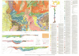 |
Geologic map of the Salt Lake City 30' X 60' quadrangle, north-central Utah, and Uinta County, Wyoming | 1990 | ||
| 81 |
 |
Bibliography of oil-impregnated rock deposits of Utah | 1979-11 | ||
| 82 |
 |
Geology of Circle Cliffs Anticline | 1954 | geology; Circle Cliffs Anticline; stratigraphy; physiography | Circle Cliffs anticline occupies an area, approximately fifteen miles wide, which extends in a northnorthwest direction from Kane County on the south through east-central Garfield County to the Wayne County line. Its axis lies approximately 25 miles east of Boulder, Utah. Hall's Creek, located at th... |
| 83 |
 |
Problems facing tar sand development | 1977-07 | Interstate Oil Compact Committee Bulletin; heavy oil deposits develompment; Tar Sand Triangle | This issue of the Interstate Oil Compact Commission Committee Bulletin contains papers presented before the meetings of the Standing Committees of the Interstate Oil Compact Commission on July 11 and 12, 1977, at Nashville, Tennessee. All available papers presented before the committees at this meet... |
| 84 |
 |
Geologic summary report of the 1984 exploration program, Sunnyside Tar Sands project, Carbon County, Utah--volume 1 | 1985-06 | geologic summary; exploration program; tar sands; Sunnyside tar sand deposit. | The 1984 Sunnyside exploration program consisted of: (1) diamond drilling of fifteen drill holes, (2) logging of all core and (3) additional geological mapping in the north area to better define the limits of the tar sands associated with the Sunnyside delta complex. Both regional and detailed geolo... |
| 85 |
 |
Sunnyside Special Tar Sand Area site specific analysis Sunnyside no. 1 tract: Moab District Price River Resource Area | 1983-03 | Sunnyside Special Tar Sand Area; site specific analysis; Sunnyside no. 1 tract; STSA; tar sand extraction | The Sunnyside No. 1 Tract is in the west part of the Sunnyside Special Tar Sand Area (STSA) in Carbon County, Utah. The tract is located about 22 miles northeast of Price (See Maps 1 and 2 in Appendix I). The legal description and ownership are shown in Table 1. The nominated tract contains 3,202.38... |
| 86 |
 |
Utah geological and mineral survey report of investigation: The Hill Creek oil-impregnated sandstone deposit | 1985-09 | geological and mineral survey; Hill Creek deposit; oil-impregnated sandstone | The Hill Creek oil-impregnated sandstone deposit is located on the rugged, southern flank of the Uinta Basin, in Uintah County, Utah. It lies westward of the P.R. Springs oil-impregnated sandstone deposit, being separated by the Willow Creek drainage system. It also lies eastward of the Sunnyside oi... |
| 87 |
 |
A comparison of biomakers in gilsonite, oil shale, tar sand and petroleum from Threemile Canyon and adjacent areas in the Uinta Basin, Utah | 1992 | Gilsonite; Oil shale; Tar sand; Petroleum; Threemile Canyon; Uinta Basin; Utah; Green River; Hopane; Sterane; Carotenoid biomarkers; Alginite; GC/MS; Ion fragmentograms; Biodegradation; Maturation; Oil shale outcrops; Bluebell-Altamont; Red Wash field; Bitumen; Pyrolysis; Py-GC/MS; Curie-point pyrol... | Relationships between gilsonite, oil shale and petroleum were investigated by comparison of hopane, sterane and carotenoid biomarkers. Samples examined were alginite, gilsonite, oil shale, tar sand and petroleum. Comparison of peak distributions in specific GC/MS ion fragmentograms of the above hydr... |
| 88 |
 |
Bituminous sandstone and limestone deposits of Utah | 1963 | The significant bituminous sandstone and bituminous Limestone deposits of Utah are located within, or on the edges of, the Uinta Basin. They are all located within the boundaries of Carbon, Duchesne, and Uintah Counties. The Sunnyside deposits in Carbon County contain the greatest reserves of bitumi... | |
| 89 |
 |
Uinta Basin tar sand deposits | 1990 | Uinta Basin; Tar sand deposits; Utah | This report addresses an important need to the State of Utah; to define, tabulate, and document an economic resource which has aroused the interest of industry and academia and which is vastly undeveloped and little understood as to its potential. The need for this report has grown since the last ta... |
| 90 |
 |
Characterization and beneficiation of bitumen-free domestic tar sands | 1982-09 | The Federal Bureau of Mines conducted a study to determine if residues from fractional distillation represent a potential source of mineral values. Aliterature review and discussions with tar sand specialists failed to disclose the mineralogical nature of residues remaining after bitumen extraction.... | |
| 91 |
 |
Fischer Assay Data, Utah Geological Survey Well Number U021 | 2008 | This dataset contains the results of Fischer assay analyses obtained and published by the Utah Geological Survey for well U021. | |
| 92 |
 |
Petroliferous lithosomes in the Moenkopi Formation, southern Utah | 1977 | petroleum; stratigraphic study; southeastern and central Utah petroleum; Moenkopi Formation | Recent stratigraphic studies of the Triassic Moenkopi Formation suggest the possibility of important petroleum potential within the unit in southeastern and central Utah. Potential reservoir rocks include shoreline sandstone in the Black Dragon Member, carbonates in the Sinbad Limestone Member, and ... |
| 93 |
 |
Lands with wilderness characteristics: Impacts on oil shale and oil sands development | 2012-05-15 | oil shale; oil sands development; LWC; BLM | Presentation describing the oil shale and sands development in Utah. |
| 94 |
 |
The Whiterocks tar sand deposit | 1985 | Whiterocks tar sand deposit; tar sand; bitumen; tar-bearing Navajo Sandstone | The Whiterocks tar sand deposit is located near the mouth of Whiterocks Canyon, an important south drainage of the Uinta Mountains. This deposit is probably the least known and most unique of the major bitumen accumulations in the Uinta Basin. Historically, it is near the purported oldest white sett... |
| 95 |
 |
Bibliography of tar sand deposits in Utah | 1987 | ||
| 96 |
 |
Sunnyside Special Tar Sand Area site specific analysis Sunnyside no. 9 tract: Moab District, Price River Resource Area | 1983-03 | Sunnyside Special Tar Sand Area; STSA; site analysis; site specific analysis; Sunnyside no. 9 tract; tar sand extraction | The Sunnyside No. 9 Tract is in the southeastern part of the Sunnyside Special Tar Sand Area (STSA) in Carbon County, Utah. The tract is located about 33 miles east of Price (See Maps 1 and 2 in Appendix I). The legal description and ownership are shown in Table 1. |
| 97 |
 |
Potential hydrologic impacts of a tar-sand industry in 11 special tar sand areas in eastern Utah | 1983 | crude oil tar-sand deposits; U.S. Bureau of Land Management; Tar Sand Triangle area; hydrolic impact | About 93 percent of the Nation's estimated 30 billion barrels of crude oil in tar-sand deposits is in 11 areas in eastern Utah that were chosen for leasing by the U.S. Bureau of Land Management. The largest deposit, which is in the Tar Sand Triangle area, contains about 15 billion barrels of oil. Th... |
| 98 |
 |
Geology of the Mill Fork Area, Utah | 1972-12 | geology; Mill Fork area; geologic structure; Green River formation | The Mill Fork area comprises about 70 square miles of Cretaceous ( ? ) and Tertiary sediments at the northern end of the Wasatch Plateau in Utah County, Utah. Over 9000 feet of nonmarine sediments are present and belong to the North Horn, Flagstaff, and Green River formations. These sediments record... |
| 99 |
 |
Ground-water flow and migration of hydrocarbons to the Lower Permian White Rim Sandstone, Tar Sand Triangle, southeastern Utah | 1995 | ground-water flow; migration of hydrocarbons; hydrocarbons; Lower Permian White Rim Sandstone; Tar Sand Triangle; heavy oil | The Lower Permian White Rim Sandstone in the Tar Sand Triangle of southeastern Utah contains an estimated 12.5-16 billion barrels of heavy oil. Despite the large size of the deposit, the source of its oil is unknown. This paper systematically discusses source rocks for this petroleum from the standp... |
| 100 |
 |
Major tar sand and heavy oil deposits of the United States | 1985-07 | major tar sand; heavy oil deposits; heavy oil resources; tar sand resources; United States | This paper presents a current assessment of U.S. tar sand and heavy oil resources. It is based on an independent appraisal of all tar sand deposits with 100 million barrels in place or more and the construction of a heavy oil reservoir and data base of fields containing more than 20 million barrels ... |