TO
Filters: Collection: "ir_eua" Type: "Text"
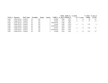
| Title | Date | Subject | Description | ||
|---|---|---|---|---|---|
| 1 |
 |
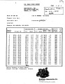
Fischer Assay Data, Utah Geological Survey Well Number U481 | 2008 | This dataset contains the results of Fischer assay analyses obtained and published by the Utah Geological Survey for well U481. | |
| 2 |
 |
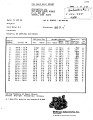
Fischer Assay Data, Utah Geological Survey Well Number U179 | 2008 | This dataset contains the results of Fischer assay analyses obtained and published by the Utah Geological Survey for well U179. | |
| 3 |
 |
Fischer Assay Data, Utah Geological Survey Well Number U177 | 2008 | This dataset contains the results of Fischer assay analyses obtained and published by the Utah Geological Survey for well U177. | |
| 4 |
 |
A brief history of early mineral exploitation in the Uinta Basin | 1964 | Uinta Basin; Mining; Uintah Valley; Indian Reservation; Meeker; Utah; History of early mineral exploitation; Uintah Reservation; Gilsonite; Coal; Copper; Iron; Oil shale; Ozocerite; Wurtzilite; Oil; Asphalt; Ashley Creek; Hatchtown; Vernal; Fort Duchesne; Ouray Subagency | Early mining activities in the Uinta Basin can be summarized by saying that they included mining for gilsonite, coal, copper, iron, oil shale, ozocerite, wurtzilite, and oil and asphalt (under the placer mining laws). Of these minerals only coal and gilsonite were produced in commercially significan... |
| 5 |
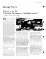 |
Is tar sand development part of our future? | 1995-04 | tar sand development; tar sand; oil production | What a difference a decade makes. It has been almost 10 years since the last of several attempts to produce oil from the tar sands at Asphalt Ridge near Vernal, Utah. The only activity since that time has been mining the tar sand for road repair and paving material. The problem is not availability, ... |
| 6 |
 |
A proposed oil extraction and strip-mining project | 1974-08-23 | The Utah Division of Oil & Gas Conservation, 1588 West North Temple, Salt Lake City, Utah, has received an application from the Sohio Petroleum Company to conduct mining operations for the removal and processing of the commercially minable deposits of bituminous sands on the following described land... | |
| 7 |
 |
Fischer Assay Data, Utah Geological Survey Well Number U178 | 2008 | This dataset contains the results of Fischer assay analyses obtained and published by the Utah Geological Survey for well U178. | |
| 8 |
 |
Environmental assessment: Tar sand in situ steam injection experiment | 1979-12 | LETC; in situ recovery of bitumen from tar sand; tar sand; bitumen | The U. S. Department of Energy - Laramie Energy Technology Center (LETC) intends to conduct a field experiment for the in situ recovery of bitumen from tar sand. The experimental site is located on a ten acre site approximately 6.5 miles West of Vernal, Utah. The operational phase of the experiment ... |
| 9 |
 |
Local issues for Utah oil sands | 2008-02-22 | Utah oil sands; tar sand history; Western U.S. oil sands | Tar sand history in Uintah County. |
| 10 |
 |
Engineering prospects of a field test thermal recovery of oil from tar sands Asphalt Ridge, Uintah County, Utah | 1959-04-25 | tar sand deposits; thermal recovery methods; tar sand; oil field; Asphalt Ridge | In late 1956 Sohio acquired certain interests in tar sand deposits at Asphalt Ridge a few miles west of Vernal, Utah. During 1957 and 1953 we conducted an extensive coring program to evaluate those shallower areas most susceptible to mining and air injection tests to evaluate those deeper areas most... |
| 11 |
 |
Utah energy: Perspective on unconventional fuels development | 2010-04-28 | Utah energy; oil shale basins; unconventional fuels. | Utah energy goals: 1) Affordable energy 2) Sustainable economy 3) Strengthen energy security and independence 4) Reduce emissions |
| 12 |
 |
APPENDIX D - Meeting data needs to perform a water impact assessment for oil shale development in the Uinta and Piceance Basins, A subpart of project - Quantifying water availability impacts and protecting water quality while developing Utah oil shale and sands - Final Project Report - Reporting period: June 21, 2006 to October 21, 2009 | 2009-06-23 | Uinta Basin; Piceance Basins; Water impact assessments; Oil shale development | The goal of this project was to mitigate water resources impacts from oil shale development in the U.S. by compiling geospatial data and water use estimates to assess water availability impacts. |
| 13 |
 |
Estimating water requirements of oil shale development in the Uintah/Piceance Basins | 2008-03-12 | water requirements; oil shale development; water resources; oil sands | Collect geospatial data and information on water resources associated information related to oil sands and oil shale development -Conduct a regional analysis of water requirements for oil shale development incorporation urbanization, alternative energy development, and wastewater recycling/reuse -De... |
| 14 |
 |
Bituminous sandstones in the Uinta Basin | 1964 | The largest single deposit of bituminous sandstones in the United States is found in the Uinta Basin. This deposit along with two other well known occurrences of bituminous sandstones in the northeastern portion of the basin have proved reserves exceeding 1% billion barrels of oil. The reserve calcu... | |
| 15 |
 |
Earth Energy Resources, Inc. oil sands production in Utah: Continued development | 2009-02-27 | Oil Sand; Utah; Hydrocarbon Energy Environmental Gap; HEEG; Earth Energy; Oil sand production; Ophus Process; Oil sand deposits; Bitumen extraction; Oil sand mining; EER Spring Mine Site; Vernal, Utah | Overview of Earth Energy Resources, Inc.'s continuing oil sands development activities in Utah, presented at the 2009 Western U.S. Oil Sands Conference by D. Glen Snarr, President & Chief Financial Officer, Earth Energy Resources, Inc. |
| 16 |
 |
Federal oil shale development: Status of Bureau of Land Management oil shale activities | 2011-05-17 | oil shale development; oil shale; land management; Bureau of Land Management; domestic oil shale | |
| 17 |
 |
Energy development in the Uintah Basin: economic and demographic impacts | 1981-07 | This report, "Energy Developments in the Uintah Basin: Economic and Demographic Impacts," is one of aseries of reports issued by the State Planning Coordinator's Office that are designed to support comprehensive planning and the development of a Utah growth management strategy. The report is intende... | |
| 18 |
 |
Investigation of tar sand and heavy oil deposits of Utah for underground coal gasification applications | 1985-12 | tar sand; heavy oil deposits; underground coal gasification; UCG applications | A literature review was conducted to determine spatial and geological relationships between Utah's tar sand or heavy oil deposits and coal deposits and to evaluate these relationships in terms of suitability for underground coal gasification (UCG) applications. The investigation was undertaken as pa... |
| 19 |
 |
Bituminous sandstone and limestone deposits of Utah | 1963 | The significant bituminous sandstone and bituminous Limestone deposits of Utah are located within, or on the edges of, the Uinta Basin. They are all located within the boundaries of Carbon, Duchesne, and Uintah Counties. The Sunnyside deposits in Carbon County contain the greatest reserves of bitumi... | |
| 20 |
 |
Heavy oil prospect NW Asphalt Ridge Uintah County, Utah | 1975 | heavy oil; heavy oil prospect; NW Asphalt Ridge; thermal recovery project | A 150 million barrel accumulation of heavy oil (14° API) underlies an 1120 acre Tom Brown, Inc. tract located six miles west of Vernal, Utah. A recently completed six-well corehole project provided the data to delineate this major accumulation. The following combination of geological and engineerin... |
| 21 |
 |
A comparison of biomakers in gilsonite, oil shale, tar sand and petroleum from Threemile Canyon and adjacent areas in the Uinta Basin, Utah | 1992 | Gilsonite; Oil shale; Tar sand; Petroleum; Threemile Canyon; Uinta Basin; Utah; Green River; Hopane; Sterane; Carotenoid biomarkers; Alginite; GC/MS; Ion fragmentograms; Biodegradation; Maturation; Oil shale outcrops; Bluebell-Altamont; Red Wash field; Bitumen; Pyrolysis; Py-GC/MS; Curie-point pyrol... | Relationships between gilsonite, oil shale and petroleum were investigated by comparison of hopane, sterane and carotenoid biomarkers. Samples examined were alginite, gilsonite, oil shale, tar sand and petroleum. Comparison of peak distributions in specific GC/MS ion fragmentograms of the above hydr... |
| 22 |
 |
Oil-impregnated sandstones of Raven Ridge, Vernal, Utah | 1972 | Oil-impregnated sandstone; Raven Ridge; Vernal, Utah; Uinta Basin; Utah; Colorado; Wasatch Formation; Green River Formation; Uinta Formation | The area of this report is in the northeastern part of the Uinta Basin of northeastern Utah and northwestern Colorado. The area covers approximately 52 square miles of what is regionally called Raven Ridge. Raven Ridge, a series of hogback ridges, trends northwest-southeast, and includes three Eocen... |
| 23 |
 |
Clean and secure energy from Utah's oil shale and oil sands resources: Environmental, legal and policy framework | 2010-04-28 | ICSE; Land use; Water availability; Produced water; Utah; Colorado; Colorado River | This poster addresses major challenges to land use, water availability, and produced water. |
| 24 |
 |
Lands with wilderness characteristics: Impacts on oil shale and oil sands development | 2012-05-15 | oil shale; oil sands development; LWC; BLM | Presentation describing the oil shale and sands development in Utah. |
| 25 |
 |
Oil sands leasing opportunities on federal land | 2009-02-27 | oil sands; leasing opportunities; federal oil sands leases and lands; BLM management plans | Overview of the process for obtaining federal oil sands leases and lands available for leasing under current BLM management plans, presented at the 2009 Western U.S. Oil Sands Conference by James Kohler, former Branch Chief of Solid Minerals, U.S. Bureau of Land Management. |