TO
Filters: Collection: "ir_eua" Subject: "Utah"
1 - 25 of 16
| Title | Date | Subject | Description | ||
|---|---|---|---|---|---|
| 1 |
 |
Salt Lake City census 2010 atlas | 2013-02 | Demographics; Salt Lake City; Utah; Census | This volume presents and analyzes results from the 2010 Census of Population and Housing. This mandatory enumeration is conducted by the federal government and is used to determine reapportionment and redistricting. This is the most complete record of population, households, and housing units that i... |
| 2 |
 |
Commercial oil shale leasing under the energy policy act: An analysis of when, where, and how | 2008-03-12 | Oil shale; Oil sands; PEIS; EPA; BLM; FLPMA; RD&D; Research, Demonstration, & Development; Tar sands; Utah; Colorado; Wyoming | Discussion of the alternatives for oil shale development outlined in the Draft Programmatic Environmental Impact Statement issued by the Bureau of Land Management. |
| 3 |
 |
Energy resources map of Utah (no. 68) | 1983-05 | Map 68; Utah; Energy Resources map; Gilsonite; Oil shale; Oil-impregnated rock; Geology; Oil and natural gas | |
| 4 |
 |
Availability of tar sands on public land: An overview | 2006-09-21 | Tar sands; public lands; Utah; Leasing on federal lands; Hydrocarbonaceous material; Oil shale; Tar sand development | Presentation summary: 1-Provide an overview of Utah Tar Sand Resources 2-Provide historical summary Tar Sand Leasing on Federal Lands; -Early leasing efforts-1960, -Combined Hydrocarbon Leasing-1981, -Energy Policy Act of 2005 3-Outline current leasing process |
| 5 |
 |
Salt Lake City census 2000 atlas | 2011-03 | Demographics; Salt Lake City; Utah; Census | This volume presents the basic demographic characteristics of residents of Salt Lake City as recorded in the 2000 Census of Population and Housing. Every ten years these federal governm ent counts of people are the basis of congressional apportionment and political redistricting. Data in this volume... |
| 6 |
 |
Clean and secure energy from Utah's oil shale and oil sands resources: Environmental, legal and policy framework | 2010-04-28 | ICSE; Land use; Water availability; Produced water; Utah; Colorado; Colorado River | This poster addresses major challenges to land use, water availability, and produced water. |
| 7 |
 |
A brief history of early mineral exploitation in the Uinta Basin | 1964 | Uinta Basin; Mining; Uintah Valley; Indian Reservation; Meeker; Utah; History of early mineral exploitation; Uintah Reservation; Gilsonite; Coal; Copper; Iron; Oil shale; Ozocerite; Wurtzilite; Oil; Asphalt; Ashley Creek; Hatchtown; Vernal; Fort Duchesne; Ouray Subagency | Early mining activities in the Uinta Basin can be summarized by saying that they included mining for gilsonite, coal, copper, iron, oil shale, ozocerite, wurtzilite, and oil and asphalt (under the placer mining laws). Of these minerals only coal and gilsonite were produced in commercially significan... |
| 8 |
 |
Historic Fort Douglas at the University of Utah | Fort Douglas; Utah | The majority of the fort was designated a National Historic Landmark in 1970. The University of Utah Fort Douglas Heritage Commons is also an Official Project of Save America's Treasures, a public-private partnership between the White House Millennium Council and the National Trust for Historic Pres... | |
| 9 |
 |
Uinta Basin tar sand deposits | 1990 | Uinta Basin; Tar sand deposits; Utah | This report addresses an important need to the State of Utah; to define, tabulate, and document an economic resource which has aroused the interest of industry and academia and which is vastly undeveloped and little understood as to its potential. The need for this report has grown since the last ta... |
| 10 |
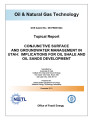 |
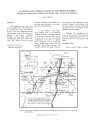
Conjunctive surface and groundwater management in Utah: Implications for oil shale and oil sands development | 2011-12-31 | Unconventional fuel development; Conjunctive water use; Surface water; Groundwater; Utah; Utah water law; Oil shale; Oil sands | Unconventional fuel development will require scarce water resources. In an environment characterized by scarcity, and where most water resources are fully allocated, prospective development will require minimizing water use and seeking to use water resources in the most efficient manner. Conjunctive... |
| 11 |
 |
Oil impregnated carbonate rocks of the Timpoweap Member Moenkopi Formation, Hurricane Cliffs area, Utah and Arizona | 1979 | Oil impregnated rocks; Hurricane Cliffs; Utah; Arizona; Timpoweap Member; Triassic Moenkopi Formation; Timpoweap Canyon; Hurricane, Utah | Oil impregnated rocks crop out at several localities near the Hurricane Cliffs in southwestern Utah and adjacent Arizona. The most significant petroliferous deposits occur in the Timpoweap Member of the Triassic Moenkopi Formation in Timpoweap Canyon and the Hurricane Cliffs south of Hurricane, Utah... |
| 12 |
 |
Clean and secure energy from domestic oil shale and oil sands resources: Quarterly progress report: April 2013 to June 2013 | 2013 | Quarterly Progress Report; April 2013 to June 2013; DE-FE0001243; Oil Shale; Oil Sands; CO2 management; Uinta Basin; Greenhouse gas; GHG emissions; oxyfiring; Utah; WTP; Ex situ; In situ | The Clean and Secure Energy from Domestic Oil Shale and Oil Sands Resources program, part of the research agenda of the Institute for Clean and Secure Energy (ICSE) at the University of Utah, is focused on engineering, scientific, and legal research surrounding the development of these resources in ... |
| 13 |
 |
Oil-impregnated sandstones of Raven Ridge, Vernal, Utah | 1972 | Oil-impregnated sandstone; Raven Ridge; Vernal, Utah; Uinta Basin; Utah; Colorado; Wasatch Formation; Green River Formation; Uinta Formation | The area of this report is in the northeastern part of the Uinta Basin of northeastern Utah and northwestern Colorado. The area covers approximately 52 square miles of what is regionally called Raven Ridge. Raven Ridge, a series of hogback ridges, trends northwest-southeast, and includes three Eocen... |
| 14 |
 |
CRS report for Congress: Developments in oil shale | 2008-11-17 | Green River; Oil shale formation; Colorado; Utah; Wyoming; Oil; Oil shale; Diesel; Jet fuel; Department of Energy; DOE; Synthetic fuels; Petroleum; Energy Policy Act of 2005; EPAct; BLM; Oil research, development, and demonstration; RD&D; Programmatic Environmental Impact Statement; PEIS; Oil shale ... | The Green River oil shale formation in Colorado, Utah, and Wyoming is estimated to hold the equivalent of 1.38 trillion barrels of oil equivalent in place. The shale is generally acknowledged as a rich potential resource; however, it has not generally proved to be economically recoverable. Thus, it ... |
| 15 |
 |
An assessment of oil shale and tar sand development in the state of Utah: Phase 1 | 1980-05 | Oil shale; Tar sand; Utah; Synthetic fuels; Tar sand development; Tar sand deposits | This assessment is the result of an interest and commitment by the State of Utah to both promote development of its vast energy resources and to manage the impacts associated with such development. As the development of Utah oil shale and tar sands became more imminent a specific proposal to study t... |
| 16 |
 |
APPENDIX A - Analysis of environmental, legal, socioeconomic and policy issues critical to the development of commercial oil shale leasing on the public lands in Colorado, Utah and Wyoming under the mandates of the Energy Policy Act of 2005 - Final Project Report - Reporting period: June 21, 2006 to October 21, 2009 | 2009-10 | Oil shale; Colorado; Utah; Wyoming; Energy Policy Act of 2005; Green River Formation; Environmental; Legal; Socioeconomic; Policy Issues; Oil shale deposits; BLM; Bureau of Land Management | The United States is home to the largest oil shale deposits in the world. This resource is located in the Green River Formation, spreading across the states of Colorado, Utah and Wyoming. Despite the vast potential of this resource, successful commercial development has yet to occur. To date, concer... |
1 - 25 of 16