TO
Filters: Collection: "ir_eua" Format: "image/jpeg"
| Title | Date | Subject | Description | ||
|---|---|---|---|---|---|
| 1 |
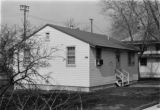 |
Photograph of the University of Utah Genetics Laboratory | University of Utah; Department of Genetics; History | Photograph of one of the earliest locations of the University of Utah Genetics Laboratory. The creation of the Department of Genetics was approved by the Board of Regents in August, 1944. The building itself is probably World War II surplus. | |
| 2 |
|
Photograph of the University of Utah Genetics Laboratory | University of Utah; Department of Genetics; History | Photograph of one of the earliest locations of the University of Utah Genetics Laboratory. The creation of the Department of Genetics was approved by the Board of Regents in August, 1944. The building itself is probably World War II surplus. | |
| 3 |
 |
Homogenizer/subsampler for tar sand process streams | |||
| 4 |
|
How Shell attempted to unlock Utah tar sands | |||
| 5 |
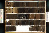
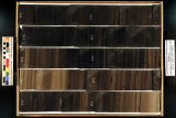 |
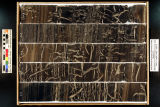
Skyline 16: SW SW sec. 10 11S 25E Uintah County, Utah. Box 16 Depth: 170.0 - 180.0 ft. | 2015-07 | core samples; Skyline 16; box 16; Green River Formation | Core sample photograph by the Utah Geological Survey, University of Utah. Skyline 16: SW SW sec. 10 11S 25E Uintah County, Utah. Box 16 Depth: 170.0 - 180.0 ft. |
| 6 |
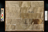
 |
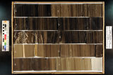
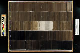
Skyline 16: SW SW sec. 10 11S 25E Uintah County, Utah. Box 12 Depth: 130.0 - 140.0 ft. | 2015-07 | core samples; Skyline 16; box 12; Green River Formation | Core sample photograph by the Utah Geological Survey, University of Utah. Skyline 16: SW SW sec. 10 11S 25E Uintah County, Utah. Box 12 Depth: 130.0 - 140.0 ft. |
| 7 |
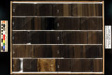
 |
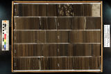
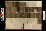
Skyline 16: SW SW sec. 10 11S 25E Uintah County, Utah. Box 8 Depth: 90.0 - 100.0 ft. | 2015-07 | core samples; Skyline 16; box 8; Green River Formation | Core sample photograph by the Utah Geological Survey, University of Utah. Skyline 16: SW SW sec. 10 11S 25E Uintah County, Utah. Box 8 Depth: 90.0 - 100.0 ft. |
| 8 |
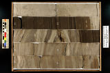
 |
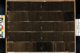
Skyline 16: SW SW sec. 10 11S 25E Uintah County, Utah. Box 9 Depth: 100.0 - 110.0 ft. | 2015-07 | core samples; Skyline 16; box 9; Green River Formation | Core sample photograph by the Utah Geological Survey, University of Utah. Skyline 16: SW SW sec. 10 11S 25E Uintah County, Utah. Box 9 Depth: 100.0 - 110.0 ft. |
| 9 |
 |
Skyline 16: SW SW sec. 10 11S 25E Uintah County, Utah. Box 19 Depth: 200.0 - 210.0 ft. | 2015-07 | core samples; Skyline 16; box 19; Green River Formation | Core sample photograph by the Utah Geological Survey, University of Utah. Skyline 16: SW SW sec. 10 11S 25E Uintah County, Utah. Box 19 Depth: 200.0 - 210.0 ft. |
| 10 |
 |
Skyline 16: SW SW sec. 10 11S 25E Uintah County, Utah. Box 11 Depth: 120.0 - 130.0 ft. | 2015-07 | core samples; Skyline 16; box 11; Green River Formation | Core sample photograph by the Utah Geological Survey, University of Utah. Skyline 16: SW SW sec. 10 11S 25E Uintah County, Utah. Box 11 Depth: 120.0 - 130.0 ft. |
| 11 |
 |
Skyline 16: SW SW sec. 10 11S 25E Uintah County, Utah. Box 17 Depth: 180.0 - 190.0 ft. | 2015-07 | core samples; Skyline 16; box 17; Green River Formation | Core sample photograph by the Utah Geological Survey, University of Utah. Skyline 16: SW SW sec. 10 11S 25E Uintah County, Utah. Box 17 Depth: 180.0 - 190.0 ft. |
| 12 |
 |
Skyline 16: SW SW sec. 10 11S 25E Uintah County, Utah. Box 4 Depth: 50.0 - 60.0 ft. | 2015-07 | core samples; Skyline 16; box 4; Green River Formation | Core sample photograph by the Utah Geological Survey, University of Utah. Skyline 16: SW SW sec. 10 11S 25E Uintah County, Utah. Box 4 Depth: 50.0 - 60.0 ft. |
| 13 |
 |
Skyline 16: SW SW sec. 10 11S 25E Uintah County, Utah. Box 18 Depth: 190.0 - 200.0 ft. | 2015-07 | core samples; Skyline 16; box 18; Green River Formation | Core sample photograph by the Utah Geological Survey, University of Utah. Skyline 16: SW SW sec. 10 11S 25E Uintah County, Utah. Box 18 Depth: 190.0 - 200.0 ft. |
| 14 |
 |
Skyline 16: SW SW sec. 10 11S 25E Uintah County, Utah. Box 5 Depth: 60.0 - 70.0 ft. | 2015-07 | core samples; Skyline 16; box 5; Green River Formation | Core sample photograph by the Utah Geological Survey, University of Utah. Skyline 16: SW SW sec. 10 11S 25E Uintah County, Utah. Box 5 Depth: 60.0 - 70.0 ft. |
| 15 |
 |
Skyline 16: SW SW sec. 10 11S 25E Uintah County, Utah. Box 10 Depth: 110.0 - 120.0 ft. | 2015-07 | core samples; Skyline 16; box 10; Green River Formation | Core sample photograph by the Utah Geological Survey, University of Utah. Skyline 16: SW SW sec. 10 11S 25E Uintah County, Utah. Box 10 Depth: 110.0 - 120.0 ft. |
| 16 |
 |
Skyline 16: SW SW sec. 10 11S 25E Uintah County, Utah. Box 3 Depth: 40.0 - 50.0 ft. | 2015-07 | core samples; Skyline 16; box 3; Green River Formation | Core sample photograph by the Utah Geological Survey, University of Utah. Skyline 16: SW SW sec. 10 11S 25E Uintah County, Utah. Box 3 Depth: 40.0 - 50.0 ft. |
| 17 |
 |
Skyline 16: SW SW sec. 10 11S 25E Uintah County, Utah. Box 13 Depth: 140.0 - 150.0 ft. | 2015-07 | core samples; Skyline 16; box 13; Green River Formation | Core sample photograph by the Utah Geological Survey, University of Utah. Skyline 16: SW SW sec. 10 11S 25E Uintah County, Utah. Box 13 Depth: 140.0 - 150.0 ft. |
| 18 |
 |
Skyline 16: SW SW sec. 10 11S 25E Uintah County, Utah. Box 7 Depth: 80.0 - 90.0 ft. | 2015-07 | core samples; Skyline 16; box 7; Green River Formation | Core sample photograph by the Utah Geological Survey, University of Utah. Skyline 16: SW SW sec. 10 11S 25E Uintah County, Utah. Box 7 Depth: 80.0 - 90.0 ft. |
| 19 |
 |
Skyline 16: SW SW sec. 10 11S 25E Uintah County, Utah. Box 2 Depth: 30.0 - 40.0 ft. | 2015-07 | core samples; Skyline 16; box 2; Green River Formation | Core sample photograph by the Utah Geological Survey, University of Utah. Skyline 16, SW SW sec. 10 11S 25E Uintah Country, Utah. Box 2 Depth: 30.0 - 40.0 ft. |
| 20 |
 |
Skyline 16: SW SW sec. 10 11S 25E Uintah County, Utah. Box 20 Depth: 210.0 - 220.0 ft. | 2015-07 | core samples; Skyline 16; box 20; Green River Formation | Core sample photograph by the Utah Geological Survey, University of Utah. Skyline 16: SW SW sec. 10 11S 25E Uintah County, Utah. Box 20 Depth: 210.0 - 220.0 ft. |
| 21 |
 |
Skyline 16: SW SW sec. 10 11S 25E Uintah County, Utah. Box 15 Depth: 160.0 - 170.0 ft. | 2015-07 | core samples; Skyline 16; box 15; Green River Formation | Core sample photograph by the Utah Geological Survey, University of Utah. Skyline 16: SW SW sec. 10 11S 25E Uintah County, Utah. Box 15 Depth: 160.0 - 170.0 ft. |
| 22 |
 |
Skyline 16: SW SW sec. 10 11S 25E Uintah County, Utah. Box 14 Depth: 150.0 - 160.0 ft. | 2015-07 | core samples; Skyline 16; box 14; Green River Formation | Core sample photograph by the Utah Geological Survey, University of Utah. Skyline 16: SW SW sec. 10 11S 25E Uintah County, Utah. Box 14 Depth: 150.0 - 160.0 ft. |
| 23 |
 |
Skyline 16: SW SW sec. 10 11S 25E Uintah County, Utah. Box 6 Depth: 70.0 - 80.0 ft. | 2015-07 | core samples; Skyline 16; box 6; Green River Formation | Core sample photograph by the Utah Geological Survey, University of Utah. Skyline 16: SW SW sec. 10 11S 25E Uintah County, Utah. Box 6 Depth: 70.0 - 80.0 ft. |
| 24 |
 |
Skyline 16: SW SW sec. 10 11S 25E Uintah County, Utah. Box 31 Depth: 320.0 - 330.0 ft. | 2015-07 | core samples; Skyline 16; box 31; Green River Formation | Core sample photograph by the Utah Geological Survey at the University of Utah, and the Utah Core Research Center. Skyline 16: SW SW sec. 10 11S 25E Uintah County, Utah. Box 31 Depth: 320.0 - 330.0 ft. |
| 25 |
 |
Skyline 16: SW SW sec. 10 11S 25E Uintah County, Utah. Box 32 Depth: 330.0 - 340.0 ft. | 2015-07 | core samples; Skyline 16; box 32; Green River Formation | Core sample photograph by the Utah Geological Survey at the University of Utah, and the Utah Core Research Center. Skyline 16: SW SW sec. 10 11S 25E Uintah County, Utah. Box 32 Depth: 330.0 - 340.0 ft. |