|
|
Title | Date | Type | Setname |
| 1 |
 |
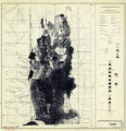
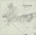
A study of primary sedimentary structures around the Moab anticline, Grand County, Utah (Google Earth map overlay KMZ file) | 1965-08 | Image | ir_etd |
| 2 |
 |
A study of primary sedimentary structures around the Moab anticline, Grand County, Utah (Thesis and maps) | 1965-08 | Text; Image | ir_etd |
| 3 |
 |
A study of primary sedimentary structures around the Moab anticline, Grand County, Utah: Georeferenced map files | 1965-08 | Image | ir_etd |
| 4 |
 |
Areal geology of the Coalville vicinity, Summit County, Utah | 1953-06 | Text; Image | ir_etd |
| 5 |
|
Areal geology of the Coalville vicinity, Summit County, Utah (Google Earth map overlay KMZ file) | 1953-06 | Image | ir_etd |
| 6 |
|
Areal geology of the Coalville vicinity, Summit County, Utah: Georeferenced map files | 1953-06 | Image | ir_etd |
| 7 |
 |
Areal geology of the Upton region, Summit County, Utah-Maps | 1953-06 | Image | ir_etd |
| 8 |
|
Areal geology of the Upton Region, Summit County, Utah: Georeferenced map files | 1953-06 | Image | ir_etd |
| 9 |
 |
Clastic laramide sediments of the Wasatch Hinterland, Northeastern Utah (Thesis and maps) | 1974 | Text; Image | ir_etd |
| 10 |
|
Clastic laramide sediments of the Wasatch Hinterland, Northeastern Utah: Georeferenced map files | 1974 | Image | ir_etd |
| 11 |
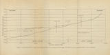 |
Figure 4: Longitudinal profile of Middle Canyon showing locations of the profiles across the canyon, the nickpoint, and the hypothetical profile before rejuvenation | 1960-08 | Image | ir_etd |
| 12 |
 |
Geologic setting and origin of the Grouse Creek pluton, Box Elder County, Utah-Maps | 1959-06 | Image | ir_etd |
| 13 |
|
Geologic setting and origin of the Grouse Creek pluton, Box Elder County, Utah: Georeferenced map files | 1959-06 | Image | ir_etd |
| 14 |
 |
Geology and ground-water resources of Ogden Valley, Utah | 1972-06 | Text; Image | ir_etd |
| 15 |
|
Geology and ore deposits of the Lucin Mining District, Box Elder County, Utah and Elko County, Nevada: Georeferenced map files | 1960-08 | Image | ir_etd |
| 16 |
 |
Geology and ore deposits of the lucin mining district, Box Elder County, Utah, and Elko County, Nevada-Maps | 1960-08 | Image | ir_etd |
| 17 |
 |
Geology and structure of Stansbury Island (Thesis and maps) | 1969-06 | Text; Image | ir_etd |
| 18 |
|
Geology and structure of Stansbury Island: Georeferenced map files | 1969-06 | Image | ir_etd |
| 19 |
 |
Geology of the Big Piney area, Summit County, Utah | 1953-06 | Text; Image | ir_etd |
| 20 |
|
Geology of the Big Piney area, Summit County, Utah: Georeferenced map files | 1953-06 | Image | ir_etd |
| 21 |
 |
Geology of the Cedar Mountains,Tooele County, Utah (Thesis and maps) | 1970-06 | Text; Image | ir_etd |
| 22 |
 |
Geology of the Central and Southern silver Island Mountains Tooele County, Utah and Elko County, Nevada-Maps | 1961-06 | Image | ir_etd |
| 23 |
|
Geology of the Central and Southern Silver Island Mountains Tooele County, Utah and Elko County, Nevada: Georeferenced map files | 1961-06 | Image | ir_etd |
| 24 |
 |
Geology of the Central Mineral Range, Beaver County, Utah | 1957-08 | Text; Image | ir_etd |
| 25 |
|
Geology of the Central Mineral Range, Beaver County, Utah (Google Earth map overlay KMZ file) | 1957-08 | Image | ir_etd |
| 26 |
|
Geology of the Central Mineral Range, Beaver County, Utah: Georeferenced map files | 1957-08 | Image | ir_etd |
| 27 |
 |
Geology of the Cove Creek area Millard County and Beaver County, Utah | 1961-06 | Text; Image | ir_etd |
| 28 |
 |
Geology of the Davis Knolls and northern Big Davis Mountain area, Tooele County, Utah | 1962-08 | Text; Image | ir_etd |
| 29 |
|
Geology of the Davis Knolls and northern Big Davis Mountain area, Tooele County, Utah (Google Earth map overlay KMZ file) | 1962-08 | Image | ir_etd |
| 30 |
|
Geology of the Davis Knolls and northern Big Davis Mountain area, Tooele County, Utah: Georeferenced map files | 1962-08 | Image | ir_etd |
| 31 |
 |
Geology of the East Canyon area, Morgan County, Utah | 1954 | Text; Image | ir_etd |
| 32 |
 |
Geology of the Keetley-Kamas volcanic area | 1951 | Text; Image | ir_etd |
| 33 |
|
Geology of the Keetley-Kamas volcanic area (Google Earth map overlay KMZ file) | 1951 | Image | ir_etd |
| 34 |
|
Geology of the Keetley-Kamas volcanic area: Georeferenced map files | 1951 | Image | ir_etd |
| 35 |
 |
Geology of the Lost Creek-Echo Canyon Area, Morgan and Summit Counties, Utah | 1959-06 | Text; Image | ir_etd |
| 36 |
 |
Geology of the Newfoundland Mountains, Box Elder County, Utah | 1956-12 | Text; Image | ir_etd |
| 37 |
|
Geology of the Newfoundland Mountains, Box Elder County, Utah: Georeferenced map files | 1956-12 | Image | ir_etd |
| 38 |
 |
Geology of the Northern Lakeside Mountains and the Grassy Mountains and vicinity, Tooele and Box Elder Counties, Utah | 1964-06 | Text; Image | ir_etd |
| 39 |
|
Geology of the Northern Lakeside Mountains and the Grassy Mountains and vicinity, Tooele and Box Elder Counties, Utah (Google Earth map overlay KMZ file) | 1964-06 | Image | ir_etd |
| 40 |
|
Geology of the Northern Lakeside Mountains and the Grassy Mountains and vicinity, Tooele and Box Elder Counties, Utah: Georeferenced map files | 1964-06 | Image | ir_etd |
| 41 |
 |
Geology of the Northern Silver Island Mountains, Box Elder and Tooele Counties, Utah | 1957-06 | Text; Image | ir_etd |
| 42 |
|
Geology of the Northern Silver Island Mountains, Box Elder and Tooele Counties, Utah (Google Earth map overlay KMZ file) | 1957-06 | Image | ir_etd |
| 43 |
|
Geology of the northern Silver Island Mountains, Box Elder and Tooele Counties, Utah: Georeferenced maps | 1957-06 | Image | ir_etd |
| 44 |
|
Geology of the Paria Northwest quadrangle Kane County, Utah (Google Earth map overlay KMZ file) | 1970-08 | Image | ir_etd |
| 45 |
 |
Geology of the Paria Northwest quadrangle Kane County, Utah-Maps | 1970-08 | Image | ir_etd |
| 46 |
|
Geology of the Paria Northwest quadrangle, Kane County, Utah: Georeferenced map files | 1970-08 | Image | ir_etd |
| 47 |
|
Geology of the Picture Rock Hills quadrangle, Southwestern Keg Mountains, Juab County, Utah (Google Earth map overlay KMZ file) | 1975 | Image | ir_etd |
| 48 |
 |
Geology of the Picture Rock Hills quadrangle, Southwestern Keg Mountains, Juab County, Utah (Thesis and maps) | 1975 | Text; Image | ir_etd |
| 49 |
|
Geology of the Picture Rock Hills quadrangle, Southwestern Keg Mountains, Juab County, Utah: Georeferenced map files | 1975 | Image | ir_etd |
| 50 |
 |
Geology of the Sheeprock Mountains, Tooele and Juab Counties, Utah | 1957-08 | Text; Image | ir_etd |
| 51 |
|
Geology of the Sheeprock Mountains, Tooele and Juab Counties, Utah: Georeferenced map files | 1957-08 | Image | ir_etd |
| 52 |
 |
Geology of the Smith and Morehouse-Hayden Fork area, Utah | 1952 | Text; Image | ir_etd |
| 53 |
|
Geology of the Smith and Morehouse-South Fork Area, Utah: Georeferenced map files | 1951 | Image | ir_etd |
| 54 |
 |
Geology of the Soldier Summit quadrangle, Utah (Thesis and maps) | 1965-06 | Text; Image | ir_etd |
| 55 |
|
Geology of the Soldier Summit quadrangle, Utah: Georeferenced map files | 1965-06 | Image | ir_etd |
| 56 |
 |
Geology of the Terrace and Hogup Mountains, Box Elder County, Utah | 1964-06 | Text; Image | ir_etd |
| 57 |
|
Geology of the Terrace and Hogup Mountains, Box Elder County, Utah (Google Earth map overlay KMZ file) | 1964-06 | Image | ir_etd |
| 58 |
 |
Geology of the Terrace and Hogup Mountains, Box Elder County, Utah (Maps) | 1964-06 | Image | ir_etd |
| 59 |
|
Geology of the Terrace and Hogup Mountains, Box Elder County, Utah: Georeferenced map files | 1964-06 | Image | ir_etd |
| 60 |
 |
Geology of the upper Ogden Canyon, Weber County, Utah | 1960-06 | Text; Image | ir_etd |
| 61 |
|
Geology of the upper Ogden Canyon, Weber County, Utah: Georeferenced map files | 1960-06 | Image | ir_etd |
| 62 |
|
Geology of the Wanship - Park City Region, Utah: Georeferenced map files | 1952-06 | Image | ir_etd |
| 63 |
 |
Geology of the West Tintic mining district and vicinity, Juab County, Utah | 1954-06 | Text; Image | ir_etd |
| 64 |
|
Landslides in the Coal Hill area, Kane County, Utah (Google Earth map overlay KMZ file) | 1964-06 | Image | ir_etd |
| 65 |
 |
Landslides in the Coal Hill area, Kane County, Utah (Thesis and maps) | 1964-06 | Text; Image | ir_etd |
| 66 |
|
Landslides in the Coal Hill area, Kane County, Utah: Georeferenced map files | 1964-06 | Image | ir_etd |
| 67 |
|
Map 1 Geologic map and sections of Big Piney Area, Utah (Google Earth map overlay KMZ file) | 1953-06 | Image | ir_etd |
| 68 |
|
Map 1 Geologic map of the Mineral Range, Utah (Google Earth map overlay KMZ file) | 1960-06 | Image | ir_etd |
| 69 |
|
Map 1 Geologic map of the Soldier Summit Quadrangle, Utah (Google Earth map overlay KMZ file) | 1965-06 | Image | ir_etd |
| 70 |
|
Map 1 Geology of the upper Ogden Canyon, Weber County, Utah (Google Earth map overlay KMZ file) | 1960-06 | Image | ir_etd |
| 71 |
 |
Map 1: Geologic map of Antelope intrusive and vicinity | 1950 | Image | ir_etd |
| 72 |
|
Map 1: Geologic map of Antelope intrusive and vicinity (Google Earth map overlay KMZ file) | 1950 | Image | ir_etd |
| 73 |
|
Map1 Geologic map and sections of Newfoundland Mountains, Box Elder County, Utah (Google Earth map overlay KMZ file) | 1956-12 | Image | ir_etd |
| 74 |
|
Map1 Geologic map and sections of Smith and Morehouse-Hayden Fork area, Utah (Google Earth map overlay KMZ file) | 1952 | Image | ir_etd |
| 75 |
|
Mineral deposits of the Deep Creek Mountains, Tooele and Juab Counties, Utah (Google Earth map overlay KMZ file) | 1970-08 | Image | ir_etd |
| 76 |
 |
Mineral deposits of the Deep Creek Mountains, Tooele and Juab Counties, Utah (Thesis and maps) | 1970-08 | Text; Image | ir_etd |
| 77 |
|
Mineral deposits of the Deep Creek Mountains, Tooele and Juab Counties, Utah: Georeferenced map files | 1970-08 | Image | ir_etd |
| 78 |
 |
Mount Ogden granite (Thesis and maps) | 1969-06 | Text; Image | ir_etd |
| 79 |
|
Mount Ogden granite: Georeferenced map files | 1969-06 | Image | ir_etd |
| 80 |
|
Parunuweap formation in the vicinity of Zion National Park, Utah (Google Earth map overlay KMZ file) | 1969-06 | Image | ir_etd |
| 81 |
 |
Parunuweap formation in the vicinity of Zion National Park, Utah-Maps | 1969-06 | Image | ir_etd |
| 82 |
|
Parunuweap formation in the vicinity of Zion National Park, Utah: Georeferenced map files | 1969-06 | Image | ir_etd |
| 83 |
 |
Petrogeneis of the Mineral Range Pluton, Southwestern Utah | 1960-06 | Text; Image | ir_etd |
| 84 |
|
Petrogeneis of the Mineral Range Pluton, Southwestern Utah: Georeferenced map files | 1960-06 | Image | ir_etd |
| 85 |
|
Petrology and structure of the little willow series, Wasatch Mountains, Utah (Google Earth map overlay KMZ file) | 1962-11 | Image | ir_etd |
| 86 |
 |
Petrology and structure of the Little Willow Series, Wasatch Mountains, Utah-Maps | 1962-11 | Image | ir_etd |
| 87 |
|
Petrology and structure of the little willow series, Wasatch Mountains, Utah: Georeferenced map files | 1962-11 | Image | ir_etd |
| 88 |
 |
Petrology of Lake Bonneville Gravels Salt Lake County, Utah | 1963-05 | Text; Image | ir_etd |
| 89 |
|
Petrology of Lake Bonneville Gravels Salt Lake County, Utah (Google Earth map overlay KMZ file) | 1963-05 | Image | ir_etd |
| 90 |
|
Petrology of Lake Bonneville Gravels Salt Lake County, Utah: Georeferenced map files | 1963-05 | Image | ir_etd |
| 91 |
|
Plate 1 Fence diagram Moenkopi group (Google Earth map overlay KMZ file) | 1969-06 | Image | ir_etd |
| 92 |
|
Plate 1 Generalized geologic map of the Laramide orogenic sediments of the Wasatch Hinterland (Google Earth map overlay KMZ file) | 1974 | Image | ir_etd |
| 93 |
|
Plate 1 Geologic map of Stansbury Island, Tooele County, Utah (Google Earth map overlay KMZ file) | 1969-06 | Image | ir_etd |
| 94 |
|
Plate 1 Geologic map of the Sheeprock Mountains area, Utah (Google Earth map overlay KMZ file) | 1957-08 | Image | ir_etd |
| 95 |
 |
Plate 1: Geologic map and vertical cross section of the Sulphurdale sulphur deposits, Beaver and Millard Counties, Utah | 1960-08 | Image | ir_etd |
| 96 |
|
Plate 1: Geologic map and vertical cross section of the Sulphurdale sulphur deposits, Beaver and Millard Counties, Utah (Google Earth map overlay KMZ file) | 1960-08 | Image | ir_etd |
| 97 |
 |
Plate 1: Geologic map of Northern Bryce Canyon National Park | 1961-06 | Image | ir_etd |
| 98 |
 |
Plate 1: Geologic map of the Little Willow Series, Wasatch Mountains, Utah | 1962-11 | Image | ir_etd |
| 99 |
 |
Plate 1: Geologic map of the Lothidok Range, Kenya | 1988-08 | Image | ir_etd |
| 100 |
 |
Plate 1: Geologic map of the Paria NW quadrangle, Kane County, Utah | 1970-08 | Image | ir_etd |