TO
| Title | Date | Subject | Description | ||
|---|---|---|---|---|---|
| 1 |
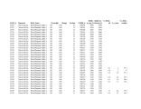 |
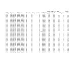
Fischer Assay Data, Utah Geological Survey Well Number U578 | 2008 | This dataset contains the results of Fischer assay analyses obtained and published by the Utah Geological Survey for well U578. | |
| 2 |
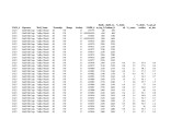 |
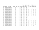
Fischer Assay Data, Utah Geological Survey Well Number U423 | 2008 | This dataset contains the results of Fischer assay analyses obtained and published by the Utah Geological Survey for well U423. | |
| 3 |
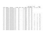 |
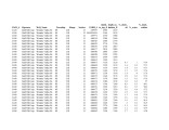
Fischer Assay Data, Utah Geological Survey Well Number U437 | 2008 | This dataset contains the results of Fischer assay analyses obtained and published by the Utah Geological Survey for well U437. | |
| 4 |
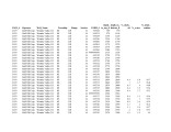 |
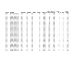
Fischer Assay Data, Utah Geological Survey Well Number U439 | 2008 | This dataset contains the results of Fischer assay analyses obtained and published by the Utah Geological Survey for well U439. | |
| 5 |
 |
Fischer Assay Data, Utah Geological Survey Well Number U436 | 2008 | This dataset contains the results of Fischer assay analyses obtained and published by the Utah Geological Survey for well U436. | |
| 6 |
 |
Fischer Assay Data, Utah Geological Survey Well Number U435 | 2008 | This dataset contains the results of Fischer assay analyses obtained and published by the Utah Geological Survey for well U435. | |
| 7 |
 |
Fischer Assay Data, Utah Geological Survey Well Number U440 | 2008 | This dataset contains the results of Fischer assay analyses obtained and published by the Utah Geological Survey for well U440. | |
| 8 |
 |
Fischer Assay Data, Utah Geological Survey Well Number U513 | 2008 | This dataset contains the results of Fischer assay analyses obtained and published by the Utah Geological Survey for well U513. | |
| 9 |
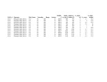 |
Fischer Assay Data, Utah Geological Survey Well Number U512 | 2008 | This dataset contains the results of Fischer assay analyses obtained and published by the Utah Geological Survey for well U512. | |
| 10 |
 |
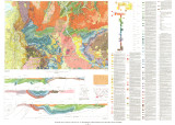
Energy resources map of Utah (no. 68) | 1983-05 | Map 68; Utah; Energy Resources map; Gilsonite; Oil shale; Oil-impregnated rock; Geology; Oil and natural gas | |
| 11 |
 |
Conjunctive surface and groundwater management in Utah: Implications for oil shale and oil sands development | 2011-12-31 | Unconventional fuel development; Conjunctive water use; Surface water; Groundwater; Utah; Utah water law; Oil shale; Oil sands | Unconventional fuel development will require scarce water resources. In an environment characterized by scarcity, and where most water resources are fully allocated, prospective development will require minimizing water use and seeking to use water resources in the most efficient manner. Conjunctive... |
| 12 |
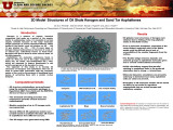 |
Atomistic modeling of oil shale kerogen and asphaltenes | 2010-04-28 | Kerogen is a mixture of organic chemical compounds that make up a portion of the organic matter in sedimentary rocks. It is insoluble in normal organic solvents because of the large molecular weight (upwards of several thousand Daltons). When heated in the Earth's crust (oil window ca. 60 ° - 120 �... | |
| 13 |
 |
When should you start thinking about wildlife? | 2006-09-21 | wildlife; wildlife resources; USFWS; habitat conservation | Utah Division of Wildlife Resources: -The Wildlife Resources Code of Utah; Title 23, Utah State Code -Utah Comprehensive Wildlife Conservation Strategy http:// www.wildlife.utah.gov/cwcs cwcs/ -Conservation Agreements -Utah Partners in Flight Avian Conservation Strategy http://www.wildlife.utah.gov/... |
| 14 |
 |
Geologic summary report of the 1990 exploration program, Sunnyside Tar Sands project, Carbon County, Utah--volume 1 | 1991-02-28 | geologic summary; exploration program; Sunnyside tar sands project; tar sand; regional, engineering geology. | This 1990 report is a supplement to the extensive 1989 report. This 1990 report concentrates on results of the following four categories: (1) regional geology and engineering geology needed to investigate the feasibility of conveyor routes that will bring the tar sand ore down from the Roan Cliffs t... |
| 15 |
 |
Geologic map of the Salt Lake City 30' X 60' quadrangle, north-central Utah, and Uinta County, Wyoming | 1990 | ||
| 16 |
 |
A brief history of early mineral exploitation in the Uinta Basin | 1964 | Uinta Basin; Mining; Uintah Valley; Indian Reservation; Meeker; Utah; History of early mineral exploitation; Uintah Reservation; Gilsonite; Coal; Copper; Iron; Oil shale; Ozocerite; Wurtzilite; Oil; Asphalt; Ashley Creek; Hatchtown; Vernal; Fort Duchesne; Ouray Subagency | Early mining activities in the Uinta Basin can be summarized by saying that they included mining for gilsonite, coal, copper, iron, oil shale, ozocerite, wurtzilite, and oil and asphalt (under the placer mining laws). Of these minerals only coal and gilsonite were produced in commercially significan... |
| 17 |
 |
Resource potential of Utah oil sands | 2008-02-22 | Utah tar sand resources; tar sand resources; tar sand | Overview of Utah tar sand resources given by John Baza, Director of Utah Division of Oil, Gas & Mining. |
| 18 |
 |
Environmental assessment: Tar sand in situ steam injection experiment | 1979-12 | LETC; in situ recovery of bitumen from tar sand; tar sand; bitumen | The U. S. Department of Energy - Laramie Energy Technology Center (LETC) intends to conduct a field experiment for the in situ recovery of bitumen from tar sand. The experimental site is located on a ten acre site approximately 6.5 miles West of Vernal, Utah. The operational phase of the experiment ... |
| 19 |
 |
An analysis of the tar sand deposit on the Rocky Mountain exploration company whiterocks federal lease Uintah County, Utah | 1982-11 | Rocky Mountain Exploration Company (hereafter called Rocky) of Salt Lake City, Utah, and Houston, Texas, holds a 240-acre federal combined hydrocarbon lease in Sections 17 and 18, T 2 N, R 1 E, UE5SM, Uintah County, Utah. The lease lies in the Ashley National Forest. Road distance is 27 miles north ... | |
| 20 |
 |
Geophysical report, seismograph survey, of the Asphalt Ridge prospect Uintah County, Utah | 1967-11 | Geophysical report; seismograph survey; Asphalt Ridge prospect. | Location and general information: The area designated as Asphalt Ridge, located directly southwest of the Ashley Creek oil field, is in the northeastern part of Uintah County, Utah, in T. 5 S. , R. 22 E. , and T. 6 S. , R. 21 E. Geologically, the area is situated on the north flank, and extends to t... |
| 21 |
 |
Colorful Gilson did more than promote gilsonite | 1996-03 | The following article from The Times-Independent in Moab pays tribute to the man for whom Gilsonite is named. Utah's American Gilsonite Company traces its roots to Sam Gilson. | |
| 22 |
 |
Geologic summary report of the 1989 exploration program, Sunnyside tar sands project, Carbon County, Utah | 1990-07-30 | geologic summary report; exploration program; Sunnyside tar sands project; tar sand. | This report includes the 1989 data and represents a summary of previous exploration reports. Eight photographs included in Volume I are used to highlight aspects of the Sunnyside. Tar Sands project. Volume II contains five maps and five cross sections. Volume III contains twenty-six strip logs. Both... |
| 23 |
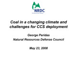 |
Coal in a changing climate and challenges for CCS deployment | 2008-05-23 | NRDC; Climate change; Coal; CCS deployment; CCS; Carbon Capture and Storage; Business-as-usual; BAU; world CO2 emissions; coal plant emissions; Appalachia; Wyoming; Montana; North Dakota; Colorado; New Mexico; IPCC; Powerplants; Arctic ice | Outline: 1-Climate and coal 2-"Clean" coal? 3-Carbon Capture & Storage: can we (just) do it? 4-To-do list 5-A changing world |
| 24 |
 |
Oil sands development in Canada: Lessons for Utah | 2009-02-27 | Canadian oil sands; oil sand development in Utah; oil sands | Analysis of the Canadian oil sands experience and its relevance to oil sands development in Utah, presented at the 2009 Western U.S. Oil Sands Conference by Simon Dyer, Oil Sands Program Director for the Pembina Institute. |
| 25 |
 |
Enhanced in-situ production through fracturing | 2010-04-28 | in-situ production; fracturing; fracturing methods | Rationale For Fracturing: 1) Ultra-Low Matrix Permeability 2) Poorly Interconnected Fracture Network 3) Desire to Maximize Surface Area, Minimize Transport Distance In Matrix and Increase Conductivity of Flow Paths For Production 4) Increase Surface Area, Increase Fracture Frequency |