TO
| Title | Date | Subject | Description | ||
|---|---|---|---|---|---|
| 1 |
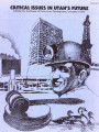 |
Critical issues in Utah's future: volume II | 1977-02 | ||
| 2 |
 |
Surface and shallow oil-impregnated rocks and shallow oil fields in the United States | 1965 | oil-impregnated rocks; shallow oil fields; petroleum-impregnated outcrops; tar sands | Petroleum-impregnated outcrops are widespread throughout eastern Utah and less so in the west and southwest. Within and around the periphery of the Uinta Basin, in the northeast are grouped some the best known "tar sands" in the United States, including the Sunnyside, Asphalt Ridge, and Whiterock de... |
| 3 |
 |
Oil-impregnated sandstone between Dirty Devil and Colorado and Green Rivers Garfield and Wayne Counties, Utah | 1969-02-26 | oil-impregnated sandstone; Utah sandstone; mineral resources inventory; Tar Sand Triangle | This paper presents the results of two months of field work done as a part of the Utah Geological Survey's continuing inventory of the mineral resources of the state of Utah. Prior to this field work. Survey field parties had worked in the area intermittently in 1967 and 1968 laying the ground work ... |
| 4 |
 |
Bibliography of oil-impregnated rock deposits of Utah | 1979-11 | ||
| 5 |
 |
Bituminous sands and some legal aspects of leasing | 1964 | A brief description of the more important bituminous sand deposits of Utah at Asphalt Ridge, Sunnyside, Whiterocks River, and other localities. Discussion of their probable origin and present physical qualities with comparison to liquid oil and natural solid bitumen deposits in Utah. Capsule history... | |
| 6 |
 |
Policy analysis of produced water issues associated with in-situ thermal technologies: Topical report: October 1, 2009 to December 31, 2010 | 2011-01 | topical report; produced water issues; in situ thermal technologies; oil shale/sands; water rights; domestic energy source | Commercial scale oil shale and oil sands development will require water, the amount of which will depend on the technologies adopted and the scale of development that occurs. Water in oil shale and oil sands country is already in scarce supply, and because of the arid nature of the region and limita... |
| 7 |
 |
APPENDIX B - Depositional heterogeneity and fluid flow modeling of the oil shale interval of the upper Green River Formation, eastern Uinta Basin, Utah - Final Project Report - Reporting period: June 21, 2006 to October 21, 2009 | 2009-10 | Green River Formation; Uinta Basin; Utah; Uintah County; Oil shale; Deposition | In this project, a detailed geological analysis was performed followed by a reservoir modeling exercise. For the geological analysis, ~300 m of cores were correlated to gamma and density logs in well P4 in the lower to middle Eocene (49.5-48.0 million years ago (Ma)), upper Green River Formation of ... |
| 8 |
 |
Bibliography of tar sand deposits in Utah | 1987 | ||
| 9 |
 |
Investigation of tar sand and heavy oil deposits of Utah for underground coal gasification applications | 1985-12 | tar sand; heavy oil deposits; underground coal gasification; UCG applications | A literature review was conducted to determine spatial and geological relationships between Utah's tar sand or heavy oil deposits and coal deposits and to evaluate these relationships in terms of suitability for underground coal gasification (UCG) applications. The investigation was undertaken as pa... |
| 10 |
 |
Assessment of research needs for oil recovery from heavy-oil sources and tar sands | 1982-03 | The Fossil Energy Research Working Group (FERWG), at the request of J. W. Mares (Assistant Secretary for Fossil Energy) and A. W. Trivelpiece (Director, Office of Energy Research), has reviewed and evaluated the U.S. programs on oil recovery from heavy oil sources and tar sands. These studies were p... | |
| 11 |
 |
The Utah process alternative futures 1975-1990, volume 1: assumptions and projections | 1975-09 | Volumes I and II of The Utah Process Alternative Futures, 1975-1990, contain the set of Alternative Future projections of economic and demographic conditions produced by the Utah State Planning Coordinator's Office for the State of Utah and its Multi-County Planning Districts (MCD) in response to th... | |
| 12 |
 |
Recovery and upgrading of oil from Utah tar sands | 1985-09 | upgrading oil; oil recovery; Utah tar sands; Bitumen Upgrading; Thermal Recovery; Fluidized Bed Pyroiysis; Water Assisted Recovery; Thermal Recovery | Research has progressed in four principal areas: A) Bitumen Upgrading; B) Thermal Recovery by Fluidized Bed Pyroiysis; C) Water Assisted Recovery; and D) Two-Stage Thermal Recovery using Heat Pipes. Hydropyrolysis continues to show promise for upgrading of bitumen with high liquid yields. Valuable e... |
| 13 |
 |
Geologic summary report of the 1988 exploration program, Sunnyside Tar Sands project, Carbon County, Utah--volume 1 | 1989-06-01 | geologic summary report; exploration program; Sunnyside tar sands project; tar sand | The 1988 field program focused on completion and logging of twelve core drill holes and three measured sections. Five marker beds were established within the Parachute Creek Member and include the Wavy Bedded Tuff, Mahogany oil shale, R-5 oil shale, lower tuff and Blue Marker containing the R-2 oil ... |
| 14 |
 |
Recovery of oil from Utah's tar sands | 1979-11-30 | oil recovery; Utah tar sands; hot water recovery; thermal processing; synthetic fuel | This project is designed to develop necessary engineering data and technology for recovery of oil from Utah's tar sands. Progress reports for four major aspects of this project, namely Hot Water Recovery, Energy Recovery in Thermal Processing, Effect of Variables in Thermal Processing and Bitumen Pr... |
| 15 |
 |
Occurrence, properties, and uses of some natural bitumens | 1961 | Natural bitumens; Hydrocarbon; Cannel coals; Torbanites | In this report, the Federal Bureau of Mines presents a summary of the occurrence, properties, and uses of some natural bitumens, using the layman's or dictionary definition of bitumens - that is, naturally occurring hydrocarbons. Emphasis is on the less common solid and semisolid bitumens, particula... |
| 16 |
 |
Geologic summary report of the 1987 exploration program, Sunnyside Tar Sands project, Carbon County, Utah--volume 1 | 1988-06-01 | geologic summary report; 1987 exploration program; Sunnyside Tar Sands project; tar sand distribution; tar sands; bituminous sandstones | 1. The distribution of tar sands in the Sunnyside deposit is related to both structure and lithology. The structural control is associated with a northwest trending flexure that segments a large monocline which slopes gently into the Uinta Basin. The lithologic control is determined by porous and pe... |
| 17 |
 |
Geologic summary report of the 1984 exploration program, Sunnyside Tar Sands project, Carbon County, Utah--volume 1 | 1985-06 | geologic summary; exploration program; tar sands; Sunnyside tar sand deposit. | The 1984 Sunnyside exploration program consisted of: (1) diamond drilling of fifteen drill holes, (2) logging of all core and (3) additional geological mapping in the north area to better define the limits of the tar sands associated with the Sunnyside delta complex. Both regional and detailed geolo... |
| 18 |
 |
Geologic summary report of the 1981 exploration program, Sunnyside Tar Sands project, Carbon County, Utah | 1982-02-19 | Geologic summary; exploration project; Sunnyside Tar Sands project; delta complex. | The 1981 Sunnyside exploration program consisted of: (1) diamond drilling of sixteen drill holes and logging of the core, and (2) initial geologic mapping in the northern area to better define the limits of the tar sands associated with the Sunnyside delta complex. In order to comprehend the geometr... |
| 19 |
 |
Geologic summary report of the 1982 exploration program, Sunnyside Tar Sands project, Carbon County, Utah | 1983-06-30 | geologic summary report; exploration program; Sunnyside Tar Sands project; tar sands; bituminous sandstone deposits | The Sunnyside tar sands are located within the southwest portion of the Uinta Basin and localized within a small delta complex that formed in Lake Uinta during early Tertiary time. The essence of the Sunnyside tar sands deposit is a sequence of laterally continuous sheet sands or stacked bituminous ... |
| 20 |
 |
Conjunctive surface and groundwater management in Utah: Implications for oil shale and oil sands development | 2011-12-31 | Unconventional fuel development; Conjunctive water use; Surface water; Groundwater; Utah; Utah water law; Oil shale; Oil sands | Unconventional fuel development will require scarce water resources. In an environment characterized by scarcity, and where most water resources are fully allocated, prospective development will require minimizing water use and seeking to use water resources in the most efficient manner. Conjunctive... |
| 21 |
 |
Barriers to industrial development in Utah's portion of the four corners region | 1970-06-01 | Utah's portion of the Four Corners area is composed of the 21 counties which are south and/or east of Salt Lake County. The Utah Four Corners area covers 65,000 square miles which is approximately 80 percent of the state. The are a has a population of 274,500 dispersed throughout the region in a ver... | |
| 22 |
 |
Quality growth efficiency tools: progress report | 1997-04 | The Quality Growth Efficiency Tools project team has been meeting since July 1996 to develop a process and set of tools to improve the quality of growth related information to plan for Utah's future. The Project's stated purpose is to improve the technical and analytical models used to forecast gr... | |
| 23 |
 |
Multi-county regions in Utah | 1970-03 | The publication of this report was made possible through the financial assistance of the Four Corners Regional Commission with coordination by the State Planning Coordinator's Office, State of Utah. The statements, findings, conclusions, recommendations, and other data in this report are solely thos... | |
| 24 |
 |
1984 baseline projections executive summary | 1984-09 | ||
| 25 |
 |
Salt Lake area transportation study: volume I current travel inventory | 1963-11 | A major element of this study was the review of current travel patterns generated by the 394,000 residents of the Salt Lake area as determined from a 1960 comprehensive origin-destination survey which was conducted by the Department of Highways. Supplemental studies covered commercial vehicle m... |