TO
| Title | Date | Subject | Description | ||
|---|---|---|---|---|---|
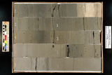
| 101 |
 | Skyline 16: SW SW sec. 10 11S 25E Uintah County, Utah. Box 97 Depth: 980.0 - 990.0 ft. | 2015-07 | core sample; Skyline 16; box 97; Green River Formation | Core sample photograph by the Utah Geological Survey at the University of Utah, and the Utah Core Research Center. Skyline 16: SW SW sec. 10 11S 25E Uintah County, Utah. Box 97 Depth: 980.0 - 990.0 ft. |
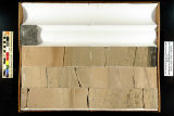
| 102 |
 | Skyline 16: SW SW sec. 10 11S 25E Uintah County, Utah. Box 98 Depth: 990.0 - 1000.0 ft. | 2015-07 | core sample; Skyline 16; box 98; Green River Formation | Core sample photograph by the Utah Geological Survey at the University of Utah, and the Utah Core Research Center. Skyline 16: SW SW sec. 10 11S 25E Uintah County, Utah. Box 98 Depth: 990.0 - 1000.0 ft. |
| 103 |
 | Skyline 16: SW SW sec. 10 11S 25E Uintah County, Utah. Box 99 Depth: 1000.0 - 1006.25 ft. | 2015-07 | core sample; Skyline 16; Green River Formation; box 99 | Core sample photograph by the Utah Geological Survey at the University of Utah, and the Utah Core Research Center. Skyline 16: SW SW sec. 10 11S 25E Uintah County, Utah. Box 99 Depth: 1000.0 - 1006.25 ft. |
| 104 |
 | U Staff Council (UUSAC) | A photograph of the members of the University of Utah Staff Council |