In 1853 Richard Hovendon Kern was hired as topographer and artist for a government-sponsored reconnaissance led by Captain John Williams Gunnison. Kern sketched landscape panoramas as the group made its way from St. Louis toward San Francisco. When the expedition reached Sevier Lake, Utah, however, it was attacked by a band of Indians. Seven men, including Kern and Gunnison, were killed, and Kern's drawings were stolen. The sketches were soon recovered and eventually carried to Washington, D.C.
Robert Shlaer, an accomplished daguerreotypist, came across Kern's sketches many years later at the Newberry Library in Chicago. He was inspired to locate the views depicted in the drawings and to photograph them, as nearly as was possible, from the same spot where Kern had stood when he sketched them. This collection juxtaposes Kern's drawings with Shlaer's photographs, presenting 389 illustrations in geographic sequence from east to west
| Title | Alternative Title | ||
|---|---|---|---|
| 1 |
 |
Plate 1 | Richard Hovendon Kern |
| 2 |
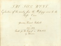 |
Plate 2 | The Far West: explorations of the country from the Mississippi River to the Pacific Ocean |
| 3 |
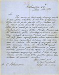 |
Plate 3 | Letter from Beckwith to Schumann |
| 4 |
 |
Plate 4 | Camp No. 1 near Westport, June 20-53 |
| 5 |
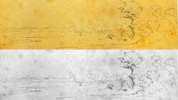 |
Plate 5 | Camp no. 1 |
| 6 |
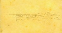 |
Plate 6 | From 82.0 on Mission and Kansas River, sketch |
| 7 |
 |
Plate 7 | Photograph of Mission Creek near its confluence with the Kansas River. |
| 8 |
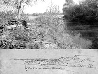 |
Plate 8 | Mission Creek and Kansas River: composite sketch and photograph |
| 9 |
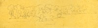 |
Plate 9 | Kansas River |
| 10 |
 |
Plate 10 | Uniontown, Kaw River |
| 11 |
 |
Plate 11 | Fort Centre or Riley, junction of Smoky Hill and Republican Fork |
| 12 |
 |
Plate 12 | Junction of the Smoky Hill and Republican river |
| 13 |
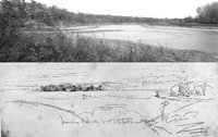 |
Plate 13 | Junction of Smoky Hill and Republican Fork, composite of drawing and photograph |
| 14 |
 |
Plate 14 | Crossing Saline Creek, July 7th 1853, sketch |
| 15 |
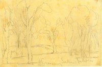 |
Plate 15 | Crossing Saline July 7th, 1853, sketch |
| 16 |
 |
Plate 16 | Elk Island, Arkansas, July 20th |
| 17 |
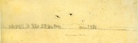 |
Plate 17 | Arkansas Plains, sketch |
| 18 |
 |
Plate 18 | Bent's Fort, sketch |
| 19 |
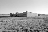 |
Plate 19 | Bent's Fort (reconstruction), photograph |
| 20 |
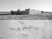 |
Plate 20 | Bent's Fort, composite sketch and photograph |
| 21 |
 |
Plate 21 | Plains (three sketches) |
| 22 |
 |
Plate 22 | Plains and distant mountains, panorama of three sketches |
| 23 |
 |
Plate 23 | Fields and distant mountains, panoramic photograph |
| 24 |
 |
Plate 24 | Plains and distant mountains panorama, composite photograph and three sketches |
| 25 |
 |
Plate 25 | Bluff on Arkansas, Aug 1st, sketch |
| 26 |
 |
Plate 26 | Panoramic photograph, Colorado plains with utility poles |
| 27 |
 |
Plate 27 | Drawing and photograph juxtaposed |
| 28 |
 |
Plate 28 | Mouth of Apishpa R. ferry, Arkansas, Aug 1st 1853. Top sketch of two on paper, 13.3 x 19.1 cm. View Plates 28-30: www.Kernsketches.com/plate/28 |
| 29 |
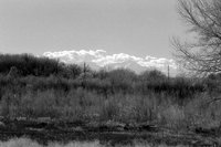 |
Plate 29 | Mouth of Apishpa River at the Arkansas River, photograph |
| 30 |
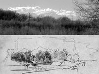 |
Plate 30 | Mouth of Apishpa River at the Arkansas River, composite sketch and photograph |
| 31 |
 |
Plate 31 | August 6th, four sketches |
| 32 |
 |
Plate 32 | Panorama of four sketches, August 6th |
| 33 |
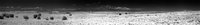 |
Plate 33 | Panorama from Mount Mestas to Pikes Peak, photograph |
| 34 |
 |
Plate 34 | Composite, panorama from Mount Mestas to Pikes Peak |
| 35 |
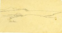 |
Plate 35 | Pikes Peak, sketch |
| 36 |
 |
Plate 36 | Pikes Peak from distance, photograph |
| 37 |
 |
Plate 37 | Pikes Peak from distance, composite sketch and photograph |
| 38 |
 |
Plate 38 | Spanish Peaks from near the Cuchara R., Aug 6th, 1853, sketch |
| 39 |
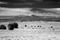 |
Plate 39 | Spanish Peaks, photograph |
| 40 |
 |
Plate 40 | Spanish Peaks, composite sketch and photograph |
| 41 |
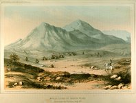 |
Plate 41 | Wah-ha-ta-gas or Spanish Peaks, Stanley lithograph from Kern sketch |
| 42 |
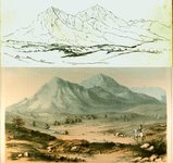 |
Plate 42 | Wah-ha-ta-gas or Spanish Peaks, composite sketch and lithograph |
| 43 |
 |
Plate 43 | Wah-ha-ta-gas or Spanish Peaks, superimposed sketch and lithograph |
| 44 |
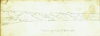 |
Plate 44 | First chain of Rocky Mts, eastern base, sketch |
| 45 |
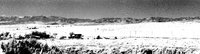 |
Plate 45 | First chain of Rocky Mts, eastern base, photograph |
| 46 |
 |
Plate 46 | First chain of Rocky Mts, eastern base, composite sketch and photograph |
| 47 |
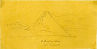 |
Plate 47 | 2d Huerfano Butte, Upper Huerfano R., sketch |
| 48 |
 |
Plate 48 | 2d Huerfano Butte, Upper Huerfano R., sketch |
| 49 |
 |
Plate 49 | 2d Huerfano Butte, Upper Huerfano R., juxtaposed sketches |
| 50 |
 |
Plate 50 | Second Huerfano Butte, photograph |
| 51 |
 |
Plate 51 | Second Huerfano Butte, composite sketch and photograph |
| 52 |
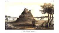 |
Plate 52 | Huerfano Butte, Gwinn Harris Heap lithograph |
| 53 |
 |
Plate 53 | Huerfano Butte, lithograph by Solomon Carvalho |
| 54 |
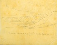 |
Plate 54 | Sierra Mohada from 2-30 Camp 40, sketch |
| 55 |
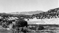 |
Plate 55 | Sierra Mohada, photograph |
| 56 |
 |
Plate 56 | Sierra Mohada, composite sketch and photograph |
| 57 |
 |
Plate 57 | Wet Mountains, sketch |
| 58 |
 |
Plate 58 | Wet Mountains, photograph |
| 59 |
 |
Plate 59 | Wet Mountains, composite sketch and photograph |
| 60 |
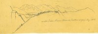 |
Plate 60 | Main chain, Sierra Blanca, eastern slopes, Aug. 10th, sketch |
| 61 |
 |
Plate 61 | Main chain, Sierra Blanca, eastern slopes, photograph |
| 62 |
 |
Plate 62 | Main chain, Sierra Blanca, eastern slopes, composite sketch and photograph |
| 63 |
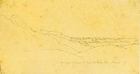 |
Plate 63 | View eastward from El Sangre de Cristo Pass, Huerfano_R., sketch |
| 64 |
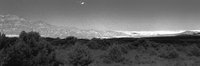 |
Plate 64 | View eastward from El Sangre de Cristo Pass, Huerfano_River, photograph |
| 65 |
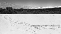 |
Plate 65 | View eastward from El Sangre de Cristo Pass, Huerfano_River, composite sketch and photograph |
| 66 |
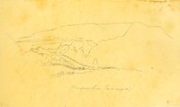 |
Plate 66 | Huerfano River near Camp 40, sketch |
| 67 |
 |
Plate 67 | Huerfano River, photograph |
| 68 |
 |
Plate 68 | Huerfano River, composite sketch and photograph |
| 69 |
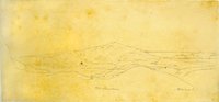 |
Plate 69 | Wet Mountains, Huerfano R, sketch |
| 70 |
 |
Plate 70 | Wet Mountains, Huerfano River photograph |
| 71 |
 |
Plate 71 | Wet Mountains, Huerfano River composite sketch and photograph |
| 72 |
 |
Plate 72 | Les Trois Tetons in the distance, Sierra Blanca, sketch |
| 73 |
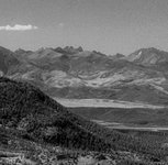 |
Plate 73 | Photograph of Les Trois Tetons from higher up |
| 74 |
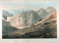 |
Plate 74 | View of Sangre de Cristo Pass, Stanley lithograph from Kern sketch |
| 75 |
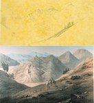 |
Plate 75 | View of Sangre de Cristo Pass, composite lithograph and sketch |
| 76 |
 |
Plate 76 | Sangre de Cristo Pass area, panoramic photograph |
| 77 |
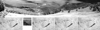 |
Plate 77 | Sangre de Cristo Pass area, panoramic photograph and sketches |
| 78 |
 |
Plate 78 | In Sangre de Cristo Pass, Aug. 11th, sketch |
| 79 |
 |
Plate 79 | Sangre de Cristo Pass area, panoramic photograph |
| 80 |
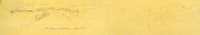 |
Plate 80 | Sangre de Cristo Pass area, panorama of sketches |
| 81 |
 |
Plate 81 | Sangre de Cristo Pass area, composite of photograph and sketches |
| 82 |
 |
Plate 82 | Sangre de Cristo Pass, panorama of sketches |
| 83 |
 |
Plate 83 | Sangre de Cristo Pass, panoramic photograph |
| 84 |
 |
Plate 84 | Sangre de Cristo Pass, composite of panoramic photograph and sketches |
| 85 |
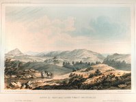 |
Plate 85 | Sangre de Cristo Pass, looking toward San Luis Valley, Stanley lithograph from Kern sketch |
| 86 |
 |
Plate 86 | Sangre de Cristo Pass, looking from the summit down Gunnison's Creek: Stanley lithograph from Kern sketch |
| 87 |
 |
Plate 87 | Sangre de Cristo Pass, composite of panorama of sketches and two lithographs |
| 88 |
 |
Plate 88 | Sangre de Cristo Pass [untitled sketch] |
| 89 |
 |
Plate 89 | Sangre de Cristo Pass, photograph |
| 90 |
 |
Plate 90 | Sangre de Cristo Pass, composite of photograph and sketch |
| 91 |
 |
Plate 91 | St. Louis Valley, Williams Ranch, Sangre de Cristo Pass area, sketch |
| 92 |
 |
Plate 92 | San Luis Valley, Williams Ranch, Sangre de Cristo Pass area, photograph |
| 93 |
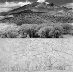 |
Plate 93 | San Luis Valley, Williams Ranch, Sangre de Cristo Pass area, composite of photograph and sketch |
| 94 |
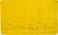 |
Plate 94 | Main peaks of Sierra Blanca, sketch |
| 95 |
 |
Plate 95 | Main peaks of Sierra Blanca, photograph |
| 96 |
 |
Plate 96 | Main peaks of Sierra Blanca, composite of photograph and sketch |
| 97 |
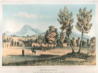 |
Plate 97 | Fort Massachusetts, at the foot of the Sierra Blanca; Valley of San Luis, Stanley lithograph from Kern sketch |
| 98 |
 |
Plate 98 | Fort Massachusetts and Main peaks of Sierra Blanca, composite of lithograph and sketch |
| 99 |
 |
Plate 99 | Panorama of sketches from near old Fort Valdez, August 20th |
| 100 |
 |
Plate 100 | Panoramic photograph, Sangre de Cristo Range from near site of Fort Valdez |