1 - 25 of 8
| Title | Date | Type | Setname | ||
|---|---|---|---|---|---|
| 1 |
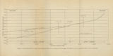 |
Figure 4: Longitudinal profile of Middle Canyon showing locations of the profiles across the canyon, the nickpoint, and the hypothetical profile before rejuvenation | 1960-08 | Image | ir_etd |
| 2 |
 |
Fluidization of coked sands and pyrolysis of oil sands in a fluidized bed reactor (Abstract only) | 1995-12 | Text | ir_eua |
| 3 |
|
Hydrotreating the Whiterocks oil sand bitumen and bitumen-derived liquid (Abstract only) | 1992-12 | Text | ir_eua |
| 4 |
 |
Map 1: Geologic map of Antelope intrusive and vicinity | 1950 | Image | ir_etd |
| 5 |
 |
Plate 1: Geologic map of Northern Bryce Canyon National Park | 1961-06 | Image | ir_etd |
| 6 |
 |
Plate 3: Geologic map and sections of Wanship-Park City region, Utah | 1952-06 | Image | ir_etd |
| 7 |
 |
Plate 3: Geologic map of portion of Northwestern Uinta Mountains, Utah | 1951 | Image | ir_etd |
| 8 |
 |
Plate1-part1 Geologic map of the Central Mineral Range, Beaver County, Utah | 1957-08 | Image | ir_etd |
1 - 25 of 8