Home
Browse
Ask Us
Chat
Harmful Language Statement
Log in
Advanced Search
Year
1950
1951
1952
1953
1954
1955
1956
1957
1958
1959
1960
1961
1962
1963
1964
1965
1966
1967
1968
1969
1970
1971
1972
1973
1974
1975
1976
1977
1978
1979
1980
1981
1982
1983
1984
1985
1986
1987
1988
1989
1990
1991
1992
1993
1994
1995
1996
1997
1998
1999
2000
2001
2002
2003
2004
2005
2006
2007
2008
2009
2010
2011
2012
2013
2014
2015
2016
TO
1950
1951
1952
1953
1954
1955
1956
1957
1958
1959
1960
1961
1962
1963
1964
1965
1966
1967
1968
1969
1970
1971
1972
1973
1974
1975
1976
1977
1978
1979
1980
1981
1982
1983
1984
1985
1986
1987
1988
1989
1990
1991
1992
1993
1994
1995
1996
1997
1998
1999
2000
2001
2002
2003
2004
2005
2006
2007
2008
2009
2010
2011
2012
2013
2014
2015
2016
Type
Image
40
Text
4
Dataset
1
InteractiveResource
1
Format
application/zip
50
Institution
Institutional Repository
46
Utah American Indian Digital Archive
3
Eccles Health Sciences Library
1
Collection
Electronic University Archive
4
Health Education Assets Library (HEAL)
1
Theses & Dissertations
38
UAIDA Main Collection
3
UScholar Works
4
Filters:
Format:
"application/zip"
Year End:
2012
26
-
50
of
50
<
1
2
>
Gallery view
Number of results to display per page
10
25
50
100
200
Sort by Relevance
Sort by Title A-Z
Sort by Title Z-A
Sort by Date Ascending
Sort by Date Descending
Sort by Last Modified Ascending
Sort by Last Modified Descending
Title
Date
Type
Setname
26
Geology of the Sheeprock Mountains, Tooele and Juab Counties, Utah: Georeferenced map files
1957-08
Image
ir_etd
27
Geology of the Smith and Morehouse-South Fork Area, Utah: Georeferenced map files
1951
Image
ir_etd
28
Geology of the Soldier Summit quadrangle, Utah: Georeferenced map files
1965-06
Image
ir_etd
29
Geology of the Terrace and Hogup Mountains, Box Elder County, Utah: Georeferenced map files
1964-06
Image
ir_etd
30
Geology of the upper Ogden Canyon, Weber County, Utah: Georeferenced map files
1960-06
Image
ir_etd
31
Geology of the Wanship - Park City Region, Utah: Georeferenced map files
1952-06
Image
ir_etd
32
Landslides in the Coal Hill area, Kane County, Utah: Georeferenced map files
1964-06
Image
ir_etd
33
Mineral deposits of the Deep Creek Mountains, Tooele and Juab Counties, Utah: Georeferenced map files
1970-08
Image
ir_etd
34
Mount Ogden granite: Georeferenced map files
1969-06
Image
ir_etd
35
Parunuweap formation in the vicinity of Zion National Park, Utah: Georeferenced map files
1969-06
Image
ir_etd
36
Petrogeneis of the Mineral Range Pluton, Southwestern Utah: Georeferenced map files
1960-06
Image
ir_etd
37
Petrology and structure of the little willow series, Wasatch Mountains, Utah: Georeferenced map files
1962-11
Image
ir_etd
38
Petrology of Lake Bonneville Gravels Salt Lake County, Utah: Georeferenced map files
1963-05
Image
ir_etd
39
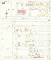
Salt Lake City, 1950: Sheet 163
1950
Image
ir_uspace
40
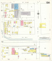
Salt Lake City, 1950: Sheet 164
1950
Image
ir_uspace
41
Stratigraphic analysis of the Mesaverde Group, Uinta Basin, Utah: Georeferenced map files
1961-05
Image
ir_etd
42
Structural geology of the Willard Peak Area, North-Central Wasatch Mountains, Utah: Georeferenced map files
1972-12
Image
ir_etd
43
Subsurface geology of the Mesozoic formations overlying the Uncompahgre Uplift in Grand County, Utah: Georeferenced map files
1961-06
Image
ir_etd
44
Subsurface stratigraphy of the Wasatch Formation of the Uinta Basin, Utah: Georeferenced map files
1963-05
Image
ir_etd
45
Tertiary Salt Lake group in the Great Salt Lake Basin: Georeferenced map files
1955-07
Image
ir_etd
46
The Thaynes formation of the Moenkopi group, North-Central Utah: Georeferenced map files
1969-06
Image
ir_etd
47
We Shall Remain: Utah Indian Elementary Curriculum Guide; 4th Grade
2009
Text
uaida_main
48
We Shall Remain: Utah Indian High School Curriculum Guide
2009
Text
uaida_main
49
We Shall Remain: Utah Indian Junior High Curriculum Guide
2009
Text
uaida_main
50
XRF data for Skyline 16
2011-05-12
ir_eua
26
-
50
of
50
<
1
2
>