Home
Browse
Ask Us
Chat
Harmful Language Statement
Log in
Institutional Repository
Advanced Search
Year
1905
1906
1907
1908
1909
1910
1911
1912
1913
1914
1915
1916
1917
1918
1919
1920
1921
1922
1923
1924
1925
1926
1927
1928
1929
1930
1931
1932
1933
1934
1935
1936
1937
1938
1939
1940
1941
1942
1943
1944
1945
1946
1947
1948
1949
1950
1951
1952
1953
1954
1955
1956
1957
1958
1959
1960
1961
1962
1963
1964
1965
1966
1967
1968
1969
1970
1971
1972
1973
1974
1975
1976
1977
1978
1979
1980
1981
1982
1983
1984
1985
1986
1987
1988
1989
1990
1991
1992
1993
1994
1995
1996
1997
1998
1999
2000
2001
2002
2003
2004
2005
2006
2007
2008
2009
2010
2011
2012
2013
2014
2015
2016
2017
2018
2019
TO
1905
1906
1907
1908
1909
1910
1911
1912
1913
1914
1915
1916
1917
1918
1919
1920
1921
1922
1923
1924
1925
1926
1927
1928
1929
1930
1931
1932
1933
1934
1935
1936
1937
1938
1939
1940
1941
1942
1943
1944
1945
1946
1947
1948
1949
1950
1951
1952
1953
1954
1955
1956
1957
1958
1959
1960
1961
1962
1963
1964
1965
1966
1967
1968
1969
1970
1971
1972
1973
1974
1975
1976
1977
1978
1979
1980
1981
1982
1983
1984
1985
1986
1987
1988
1989
1990
1991
1992
1993
1994
1995
1996
1997
1998
1999
2000
2001
2002
2003
2004
2005
2006
2007
2008
2009
2010
2011
2012
2013
2014
2015
2016
2017
2018
2019
Type
Text
62
Image
6
Format
application/pdf
67
Collection
Honors Theses Closed Archive
1
Theses & Dissertations
66
Filters:
Department:
"Mining Engineering"
Format:
"application/pdf"
26
-
50
of
67
<
1
2
3
>
Gallery view
Number of results to display per page
10
25
50
100
200
Sort by Relevance
Sort by Title A-Z
Sort by Title Z-A
Sort by Date Ascending
Sort by Date Descending
Sort by Last Modified Ascending
Sort by Last Modified Descending
Title
Date
Type
Setname
26
Fluid bed thermal recovery of synthetic crude from bituminous sands of Utah
1980-03
Text
ir_etd
27
Geochemical exploration for Gilsonite
1905-05-14
Text
ir_etd
28
Geology and ore deposits of the Santaquin mining district
1910
Text
ir_etd
29
Geology of the Haystack Range, Goshen and Platte Counties, Wyoming
1964
Text
ir_etd
30
Hustrulid bar - a dynamic strength test and its application to the cautious blasting of rock
2010
Text
ir_etd
31
Hydraulic mining plan and feasibility study for an underground coal mine at mid-continent resources, inc. Middle seam in coal basin at Carbondale, Colorado
1984-06
Text
ir_htca
32
The intervention effectiveness of a variant of distributive leadership in underground section mining
2017
Text
ir_etd
33
Intervention Effectiveness of safety health management systems: Initial assessment
2019
Text
ir_etd
34
Investigating the extent of damage from a single blasthole
2014-05
Text
ir_etd
35
Laboratory and numerical modeling used to characterize leakage in underground coal mines
2011-05
Text
ir_etd
36
Metals and mining, their bearing on civilization, in their early, and later historical aspects
1912
Text
ir_etd
37
Mining and milling of complex lead and zinc ores in the Park City district, Utah
1916
Text
ir_etd
38
Mining project evaluation process for investment decisions
2012-05
Text
ir_etd
39
Mining-induced seismicity and FLAC3D modeling at the Trail Mountain Mine
2014-12
Text
ir_etd
40
Modeling and simulation of the pore-scale multiphase fluid transport in shale reservoirs: a molecular dynamics simulation approach
2016
Text
ir_etd
41
Monitoring systems for coal mines utilizing booster fans
2014-08
Text
ir_etd
42
Normalization of deviance in mining engineering
2017
Text
ir_etd
43
Numerical investigation of pipe umbrella roof support systems in underground coal mining
2012-08
Text
ir_etd
44
Oil-shales of the United States and methods of testing
1905-04-04
Text
ir_etd
45
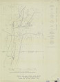
Plate 1: Geologic map and vertical cross section of the Sulphurdale sulphur deposits, Beaver and Millard Counties, Utah
1960-08
Image
ir_etd
46
Plate 2: Detailed geologic and vertical cross sections map of the Excelsior Orebody and New York Prospect Pit, Millard County, Utah
1960-08
Image
ir_etd
47
Plate 3: Detailed geologic and vertical cross section map of the Prince Albert Orebody, Mariposa and Queen Victoria Prospect Pits, Millard County, Utah
1960-08
Image
ir_etd
48
Plate 4: Detailed map showing diamond drill hole locations and vertical cross sections of the Sulphurdale Orebody, Beaver County, Utah
1960-08
Image
ir_etd
49
Porosity and moisture effects on dynamic strength of two sandstones from Utah
2015-08
Text
ir_etd
50
Prevention of spontaneous combustion in underground coal mines with the implementation of pressure balancing techniques
2016
Text
ir_etd
26
-
50
of
67
<
1
2
3
>