|
|
Title | Date | Type | Setname |
| 1 |
 |
3-D magnetic inversion with data compression and image focusing | 2002-01-01 | Text | ir_uspace |
| 2 |
 |
3D inversion of airborne electromagnetic data | 2012-01-01 | Text | ir_uspace |
| 3 |
 |
A faunule from a Shale Unit in the lower Ely Formation, West-Central Utah | 1967-06 | Text | ir_etd |
| 4 |
 |
A Preliminary study of the use of oxygen isotope ratios as an exploration tool in the Park City District, Utah | 1971 | Text | ir_etd |
| 5 |
 |
A reappraisal of the geomagnetic polarity time scale to 4 MA using data from the turkana basin, East Africa | 2012 | Text | ir_uspace |
| 6 |
 |
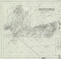
A study of primary sedimentary structures around the Moab anticline, Grand County, Utah (Google Earth map overlay KMZ file) | 1965-08 | Image | ir_etd |
| 7 |
 |
A study of primary sedimentary structures around the Moab anticline, Grand County, Utah (Thesis and maps) | 1965-08 | Text; Image | ir_etd |
| 8 |
 |
A study of primary sedimentary structures around the Moab anticline, Grand County, Utah: Georeferenced map files | 1965-08 | Image | ir_etd |
| 9 |
 |
A summary of the geology, geochemistry, and geophysics of the Roosevelt Hot Springs thermal area, Utah | 1978 | Text | ir_uspace |
| 10 |
 |
A unified theory for colloid transport: predicting attachment and mobilization under favorable and unfavorable conditions | 2019 | Text | ir_etd |
| 11 |
 |
Acoustic waveform inversion of two-dimension Gulf of Mexico data | 2009-04 | Text | ir_etd |
| 12 |
 |
Advanced methods for depth-to-basement estimation using gravity, magnetic, and electromagnetic data | 2015 | Text | ir_etd |
| 13 |
 |
Advancements in colloid filtration theory: how pore-scale physiochemical heterogeneity affects parthogen and engineered nanoparticle transport | 2019 | Text | ir_etd |
| 14 |
 |
Advances in terrestrial paleoecology from intratooth stable isotope profiles in tooth enamel and tusk dentin | 2012-12 | Text | ir_etd |
| 15 |
 |
Air, ground, and groundwater recharge temperatures in an alpine setting, Brighton Basin, Utah | 2012-01-01 | Text | ir_uspace |
| 16 |
 |
Alluvial architecture and predictive modeling of the late cretaceous John Henry member, Straight Cliffs Formation, Southern Utah | 2010-12 | Text | ir_etd |
| 17 |
 |
Alternate ecological State shifts during the Triassic-Jurassic transition: observations from the Pucara group, Peru | 2020 | Text | ir_etd |
| 18 |
 |
Ambient resonance of rock arches | 2015 | Text | ir_etd |
| 19 |
 |
An ecological snapshot of the Early Pleistocene at Kokiselei, Kenya | 2013-08 | Text | ir_etd |
| 20 |
 |
An individual migration story: comparing strontium isotope analysis in enamel, ivory, and food sources from a single modern elephant | | Text | ir_uw |
| 21 |
 |
An interdisciplinary geological and geomorphic characterization and landslide investigation in Red Butte Canyon, Utah | 2013-08 | Text | ir_etd |
| 22 |
 |
An investigation of the occurrence of uranium at Cameron, Arizona | 1957-03 | Text | ir_etd |
| 23 |
 |
An investigation of transgressive barriers in late Pleistocene Lake Bonneville | 2016 | Text | ir_etd |
| 24 |
 |
Analysis of the seismic coherence attribute with respect to subsurface fault geometry | 2009-01-06 | Text | ir_etd |
| 25 |
 |
Anatomy and assembly of the McDoogle pluton near Sawmill Lake, Central Sierra Nevada, California | 2009-06-17 | Text | ir_etd |
| 26 |
 |
Applicability of colloid filtration theory in size-distributed, reduced porosity, granular media in the absence of energy barriers | 2011-05 | Text | ir_etd |
| 27 |
 |
Applications of quantitative methods and chaos theory in Ichnology for analysis of invertebrate behavior and evolution | 2014-08 | Text | ir_etd |
| 28 |
 |
Archeomagnetic secular variation | 1976 | Text | ir_etd |
| 29 |
 |
Areal geology of the Coalville vicinity, Summit County, Utah | 1953-06 | Text; Image | ir_etd |
| 30 |
|
Areal geology of the Coalville vicinity, Summit County, Utah (Google Earth map overlay KMZ file) | 1953-06 | Image | ir_etd |
| 31 |
|
Areal geology of the Coalville vicinity, Summit County, Utah: Georeferenced map files | 1953-06 | Image | ir_etd |
| 32 |
 |
Areal geology of the Upton Region, Summit County, Utah | 1953-06 | Text | ir_etd |
| 33 |
 |
Areal geology of the Upton region, Summit County, Utah-Maps | 1953-06 | Image | ir_etd |
| 34 |
|
Areal geology of the Upton Region, Summit County, Utah: Georeferenced map files | 1953-06 | Image | ir_etd |
| 35 |
 |
Areal geology of the Wanship-Coalville Area | 1952-06 | Text | ir_etd |
| 36 |
 |
Assessing endogenous signals and contamination in keratinized tissues using trace element and strontium isotopic analysis | 2019 | Text | ir_etd |
| 37 |
 |
Assessing nutrient loads from in-situ fertilizer amendments in Willard Spur | 2014-05 | Text | ir_etd |
| 38 |
 |
Automated fault scarp offset analyses applied to the nephi segment of the wasatch fault, utah utilizing lidar-derived, high-resolution digital elevation models | 2015-05 | Text | ir_etd |
| 39 |
 |
Biogeochemical signatures in iron (oxyhydr)oxide diagenetic precipitates: chemical, mineralogical and textual markers | 2013-05 | Text | ir_etd |
| 40 |
 |
Biostratigraphy and paleoenvironments of the Cretaceous-Tertiary (K-T) North Horn Formation in the Wasatch Plateau, central Utah | 2002 | Text | ir_etd |
| 41 |
 |
Biostratigraphy of the albertella and glossopleura zones (lower middle cambrian) of Northern Utah and Southern Idaho | 1974 | Text | ir_etd |
| 42 |
 |
Biostratigraphy of the Cambrian Glossopleura zone : west-central Utah. | 1973 | Text | ir_etd |
| 43 |
 |
Bone histology and growth of chasmosaurine ceratopsid dinosaurs from the late Campanian Kaiparowits Formation, Southern Utah | 2013-05 | Text | ir_etd |
| 44 |
 |
Borehole temperatures and climate change: ground temperature change in south India over the past two centuries | 2012-01-01 | Text | ir_uspace |
| 45 |
 |
Brecciation in the Ontario mine, east flank ore bodies, Park City district, Utah. | 1973 | Text | ir_etd |
| 46 |
 |
Carbon isotope stratigraphy of early Eocene hyperthermals in the Bighorn Basin, Wyoming, USA: analogues for modern anthropogenic carbon emissions | 2013-12 | Text | ir_etd |
| 47 |
 |
Carbonate petrology of the Green River Formation (Eocene), Uinta Basin, Utah and Colorado | 1972-08 | Text | ir_etd |
| 48 |
 |
Characteristics of microseisms recorded by the earthscope transportable array | 2015-05 | Text | ir_etd |
| 49 |
 |
Characterization of Navajo sandstone hydrous ferric oxide concretions | 2009-12-03 | Text | ir_etd |
| 50 |
 |
Characterization of segmentation and long-term vertical slip rates of the wasatch fault zone, utah | 2017 | Text | ir_etd |
| 51 |
 |
Characterization of shallow shear wave velocity structures in Southwestern Utah | 2011-05 | Text | ir_etd |
| 52 |
 |
Characterizing background seismicity in the region surrounding Milford, Utah | 2017 | Text | ir_etd |
| 53 |
 |
Chesterian - Morrowan conodont biodtratigraphy from Northeastern Utah | 1973 | Text | ir_etd |
| 54 |
 |
Chronology | 1983 | Text | ir_uspace |
| 55 |
 |
Circulation, salinity, and dissolved oxygen in the Cretaceous North American seaway | 1996 | Text | ir_uspace |
| 56 |
 |
Clastic laramide sediments of the Wasatch Hinterland, Northeastern Utah (Thesis and maps) | 1974 | Text; Image | ir_etd |
| 57 |
|
Clastic laramide sediments of the Wasatch Hinterland, Northeastern Utah: Georeferenced map files | 1974 | Image | ir_etd |
| 58 |
 |
Clastic pipes and soft-sediment deformation within the jurassic carmel formation, Southern Utah: processes, controls, and implications for plaeoenvironment, subsureface fluid flow, and a near-surface groundwater system on mars | 2018 | Text | ir_etd |
| 59 |
 |
Clay mineralogy and chemical variation in uranium roll-front deposits in the Gas Hills Uranium District, Wyoming | 2013-08 | Text | ir_etd |
| 60 |
 |
Climate change in India inferred from geothermal observations | 2002 | Text | ir_uspace |
| 61 |
 |
Coastal margin reservoir quality: subsurface analysis of the late cretaceous John Henry member, Kaiparowits Plateau, Southern Utah | 2017 | Text | ir_etd |
| 62 |
 |
Columnar section of the permian unnamed formation exposed between Rydalch Pass and US Coast and geodetic survey Cedar Triangulation Station Plate VIII | | Text | ir_etd |
| 63 |
 |
Comparative ichnology of pleistocene eolianites and modern coastal dunes, puerto penasco, sonora, Mexico | 2002 | Text | ir_etd |
| 64 |
 |
Comparison of the potential metamorphic and igneous carbon dioxide fluxes from the Salton Sea Geothermal System, California | 2009-07-23 | Text | ir_etd |
| 65 |
 |
Comparison study of magnetotelluric inversion using different transfer functions | 2014-08 | Text | ir_etd |
| 66 |
 |
Concerning the Laramie Formation in Carbon County, Utah | 1905 | Text | ir_etd |
| 67 |
 |
Contraction integral equation method in three-dimensional electromagnetic modeling | 2002-01-01 | Text | ir_uspace |
| 68 |
 |
Controlled sensitivity of marine controlled-source electromagnetic surveys | 2012-05 | Text | ir_etd |
| 69 |
 |
Controls of tufa development in Pleistocene Lake Bonneville, Utah | 2006 | Text | ir_uspace |
| 70 |
 |
Correlation of tephra layers from the Western Rift Valley (Uganda) to the Turkana Basin (Ethiopia/Kenya) and the Gulf of Aden | 1991 | Text | ir_uspace |
| 71 |
 |
Correlation of tuff layers in the Green River Formation, Utah, using biotite compositions | 1974 | Text | ir_etd |
| 72 |
 |
Cross-well electromagnetic imaging in three dimensions | 2003 | Text | ir_uspace |
| 73 |
 |
Data report: high-resolution mineralogy for leg 199 based on reflectance spectroscopy and physical properties | 2004 | Text | ir_uspace |
| 74 |
 |
Data-driven methods in earthquake monitoring, detection, and catalog building | 2018 | Text | ir_etd |
| 75 |
 |
Dating | 1984 | Text | ir_uspace |
| 76 |
 |
Decoupled accommodation and sediment supply in the late cretaceous cordilleran basin of southern utah: an extrabasinal affair | 2016 | Text | ir_etd |
| 77 |
 |
Deep-sea scleractinian coral age and depth distributions in the Northwest Atlantic over the last 225,000 years | 2007 | Text | ir_uspace |
| 78 |
 |
Depositional controls on the stratigraphic variability of lacustrine sedimentary cycles, Green River Formation, Uinta Basin, Utah | 2021 | Text | ir_etd |
| 79 |
 |
Depositional environments of some upper Cretaceous coal-bearing strata at Trapper Mine, Craig, Colorado | 1982-03-19 | Text | ir_etd |
| 80 |
 |
Determination of rayleigh wave ellipticity using single-station and array-based processing of ambient seismic noise | 2016 | Text | ir_etd |
| 81 |
 |
Determining geologic controls on oil production through core-log calibration and linear regression analysis for the niobrara formation in silo field, wyoming | 2015-05 | Text | ir_etd |
| 82 |
 |
Determining mean transit times of groundwater flow systems | 2014-05 | Text | ir_etd |
| 83 |
 |
Determining transit times through hyporheic zones using passive techniques in red butte canyon | 2016 | Text | ir_etd |
| 84 |
 |
Developing a new passive diffusion sampling array to detect helium anomalies associated with volcanic unrest | 2014 | Text | ir_etd |
| 85 |
 |
Developing advanced methods for analysis and inversion of marine electromagnetic data in off-shore exploration | 2016 | Text | ir_etd |
| 86 |
 |
Development of a new colloid filtration theory in the presence of energy barriers via discrete nanoscale heterogeneity | 2015-08 | Text | ir_etd |
| 87 |
 |
Diffusion of radiogenic helium in shallow groundwater: implications for crustal degassing | 2002-08 | Text | ir_etd |
| 88 |
 |
The dirt on paleosols: sedimentology and paleoclimate indicators within the upper triassic Chinle Formation, Paria, Utah | 2012-08 | Text | ir_etd |
| 89 |
 |
Discussion and reply: comments on "electromagnetic geophysics: notes from the past and the road ahead" | 2012-01-01 | Text | ir_uspace |
| 90 |
 |
Dual multicollector laser ablation split stream mass spectrometry: Application to the Bruneau-Jarbidge volcanic center, central Snake River Plain, Idaho | 2016 | Text | ir_etd |
| 91 |
 |
Dynamic displacement analysis of a shallow landslide in Norwood Tuff | 2011-05 | Text | ir_etd |
| 92 |
 |
Dynamic earthquake triggering potential across earthscope's transportable array | 2014-08 | Text | ir_etd |
| 93 |
 |
Earllthesis1957_Part2 Geology of the Central Mineral Range, Beaver County, Utah | 1957-08 | Text | ir_etd |
| 94 |
 |
Efforts Toward Establishing ML-McAs a Robust Depth Discriminant of Seismic Sources at Local (<150 km) Distances | 2020 | Text | ir_htoa |
| 95 |
 |
Electrical properties of basalts from Sites 768 and 770 | 1991 | Text | ir_uspace |
| 96 |
 |
Electromagnetic inversion using quasi-linear approximation | 2000 | Text | ir_uspace |
| 97 |
 |
Electromagnetic modeling of porphyry systems from the grain-scale to the deposit-scale using the Generalized Effective Medium Theory of Induced Polarization | 2007-10-29 | Text | ir_etd |
| 98 |
 |
Environmental controls on the formation and isotopic composition of a laminated tufa in Red Butte Canyon, Utah | 2008-05-16 | Text | ir_etd |
| 99 |
 |
Environmental differences in tropical soil temperatures in Kenya | 2012-12 | Text | ir_etd |
| 100 |
 |
Environmental tracer investigation of groundwater conditions at the Scott M. Matheson Wetland Preserve near Moab, Utah | 2004-08 | Text | ir_etd |
| 101 |
 |
Eurypterid paleoecology : characterization and analysis of a late Silurian shallow marine fossil assemblage from southern Ontario, Canada | 2013-05 | Text | ir_htoa |
| 102 |
 |
Evaluating fluid-rock interactions in geothermal and contact metamorphic systems | 2012-05 | Text | ir_etd |
| 103 |
 |
Evaluating mudstone heterogeneity: high-resolution sedimentologic, Geochemical, and stratigraphic analysis of the wolfcamp formation in the Permian Basin, West Texas, U.S.A | 2019 | Text | ir_etd |
| 104 |
 |
Evaluation of one-dimensional seismic models of the lunar interior | 2013-08 | Text | ir_etd |
| 105 |
 |
The evolution and biogeography of ankylosaurid dinosaurs from the late cretaceous of western north america | 2016 | Text | ir_etd |
| 106 |
 |
The evolution of neogene terrestrial ecosystems in Europe | 1999 | Text | ir_uspace |
| 107 |
 |
Exceptionally preserved jellyfishes from the Middle Cambrian | 2007-10-31 | Text | ir_uspace |
| 108 |
 |
Excess pore pressure and in situ measurement of shear strength gain in clays | 1972-06 | Text | ir_etd |
| 109 |
 |
Exhumation of the central Wasatch Mountains, Utah: 1, Patterns and timing of exhumation deduced from low-temperature thermochronology data | 2002 | Text | ir_uspace |
| 110 |
 |
Exhumation of the central Wasatch Mountains, Utah: 2, thermokinematic model of exhumation, erosion, and thermochronometer interpretation | 2002 | Text | ir_uspace |
| 111 |
 |
Experimental and numerical study on the mechanism of liquefaction flow-slides in gently sloping ground | 2008-12 | Text | ir_etd |
| 112 |
 |
Experimental study of the induced polarization effect using cole-cole and gemtip models | 2010 | Text | ir_etd |
| 113 |
 |
Experimental study on the dynamic stress-strain behavior of expanded polystyrene geofoam using cyclic triaxial tests | 2011-11 | Text | ir_etd |
| 114 |
 |
Facies, Depositional Environments and Stratigraphy of the upper devonian upper member of the guilmette formation, West-Central Utah | 1989 | Text | ir_etd |
| 115 |
 |
Facies, stratigraphic architecture, and lake evolution of the oil shale bearing Green River Formation, Eastern Uinta Basin, Utah | 2013-08 | Text | ir_etd |
| 116 |
 |
Fast least squares migration with a deblurring filer | 2009-05 | Text | ir_etd |
| 117 |
 |
Fast numerical modeling of multitransmitter electromagnetic data using multigrid quasi-linear approximation | 2006-06 | Text | ir_uspace |
| 118 |
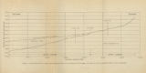 |
Figure 4: Longitudinal profile of Middle Canyon showing locations of the profiles across the canyon, the nickpoint, and the hypothetical profile before rejuvenation | 1960-08 | Image | ir_etd |
| 119 |
 |
Finite difference time domain modeling of cross-hole electromagnetic survey data | 1997-06-04 | Text | ir_etd |
| 120 |
 |
Fluvial response to Great Salt Lake level changes: observations, mechanisms and implications | 2010-05 | Text | ir_etd |
| 121 |
 |
Fluvial stratigraphic architecture of the John Henry member of the Straight Cliffs Formation, Kaiparowits Plateau, Utah USA | 2010 | Text | ir_etd |
| 122 |
 |
Fluvial-lacustrine sequence stratigraphy, provenance, ichnology, and sandstone reservoir modeling of the tertiary Uinta and Duchesne River Formation, northern Uinta Basin, Utah | 2015-05 | Text | ir_etd |
| 123 |
 |
Focusing geophysical inversion images | 1999 | Text | ir_uspace |
| 124 |
 |
Formulation for the static permittivity of water and steam at temperatures from 238 K to 873 K at pressures up to 1200 MPa, including derivatives and Debye- Hückel coefficients | 1997 | Text | ir_uspace |
| 125 |
 |
Fracture analysis, hydrodynamic properties and mineral abundance in altered igneous wall rocks of the Mayflower Mine, Park City District, Utah | 1975 | Text | ir_etd |
| 126 |
 |
Fractures and surface lineaments in northeastern Utah | 1975-12 | Text | ir_etd |
| 127 |
 |
Gamma ray spectroscopy and magnetic susceptibility of stratigraphic sequences in the Wheeler Formation, West Central Utah | 2008-09-29 | Text | ir_etd |
| 128 |
 |
GEMTIP modeling of heterogeneous rock samples using the genetic algorithms | 2017 | Text | ir_etd |
| 129 |
 |
General features of the Wasatch Mountains | 1906 | Text | ir_etd |
| 130 |
 |
General geology and sulfide mineralization of Dry Canyon and vicinity, Gunnison Plateau, Sanpete Co., Utah | 1967-06 | Text | ir_etd |
| 131 |
 |
Generalized diffraction-stack migration | 2012-12 | Text | ir_etd |
| 132 |
 |
Generation of low ?18O silicic magmas, Bruneau-Jarbidge Volcanic Center, Yellowstone hotspot: evidence from zircons, including oxygen isotopes, U-Th-Pb dating, and melt inclusions | 2012-05 | Text | ir_etd |
| 133 |
 |
Geochemical and mineralogical evaluation of CO2-brine-rock experiments: characterizing porosity and permeability variations in the Cambrian Mt. Simon sandstone | 2013-12 | Text | ir_etd |
| 134 |
 |
Geochemical results from wireline logs in the Celebes Sea, Sites 767 and 770 of Leg 124 | 1991 | Text | ir_uspace |
| 135 |
 |
Geochemical study of the origin of debris bands at Storglaciaren, Sweden | 2008-12 | Text | ir_etd |
| 136 |
 |
Geochemical variations in an alpine lake and watershed underlain by siliciclastic bedrock, Uinta Mountains, Utah | 1998-01-01 | Text | ir_uspace |
| 137 |
 |
Geochemistry and paleoceanographic setting of Central Nevada bedded barites | 1991 | Text | ir_uspace |
| 138 |
 |
Geochemistry of volcanic ash in the Salt Lake group, Bonneville Basin, Utah, Idaho, and Nevada | 1975-08 | Text | ir_etd |
| 139 |
 |
Geologic setting and origin of the Grouse Creek pluton, Box Elder County, Utah | 1959-06 | Text | ir_etd |
| 140 |
|
Geologic setting and origin of the Grouse Creek pluton, Box Elder County, Utah: Georeferenced map files | 1959-06 | Image | ir_etd |
| 141 |
 |
Geological and geophysical studies of the Gilson Mountains and vicinity, Juab County, Utah | 1970-06 | Text | ir_etd |
| 142 |
 |
Geological development of the Omo-Turkana Basin during the pliocene and pleistocene epochs | 2004 | Text | ir_uspace |
| 143 |
 |
Geology and diatremes of Desert Mountain, Utah | 1971-06 | Text | ir_etd |
| 144 |
 |
The geology and erosional development Northern Bryce Canyon National Park | 1961 | Text | ir_etd |
| 145 |
 |
Geology and erosional development of Northern Bryce Canyon National Park | 1961-06 | Text | ir_etd |
| 146 |
 |
Geology and geochemistry of the colt mesa copper deposit, Circle Cliffs Area, Utah | 1975-08 | Text | ir_etd |
| 147 |
 |
Geology and geochemistry of the Escalante Silver Veins, Iron County, Utah | 1979 | Text | ir_etd |
| 148 |
 |
Geology and geothermal potential North of Wells, Nevada | 1982-01-01 | Text | ir_uspace |
| 149 |
 |
Geology and geothermal potential of the Roosevelt Hot Springs area, Beaver County, Utah | 1975 | Text | ir_etd |
| 150 |
 |
The geology and geothermal setting of the Magic Reservoir Area, Blaine and Camas Counties, Idaho | 1982 | Text | ir_uspace |
| 151 |
 |
Geology and ground-water resources of Ogden Valley, Utah | 1972-06 | Text; Image | ir_etd |
| 152 |
 |
Geology and mineral deposits of the western portion church hills, Millard County, Utah | 1971-06 | Text | ir_etd |
| 153 |
|
Geology and ore deposits of the Lucin Mining District, Box Elder County, Utah and Elko County, Nevada: Georeferenced map files | 1960-08 | Image | ir_etd |
| 154 |
 |
Geology and structure of Stansbury Island (Thesis and maps) | 1969-06 | Text; Image | ir_etd |
| 155 |
|
Geology and structure of Stansbury Island: Georeferenced map files | 1969-06 | Image | ir_etd |
| 156 |
 |
Geology of a part of Northwestern Uinta County, Wyoming | 1961-06 | Text | ir_etd |
| 157 |
 |
The geology of Antimony Canyon area Garfield and Piute Counties, Utah | 2010 | Text | ir_etd |
| 158 |
 |
Geology of the Big Piney area, Summit County, Utah | 1953-06 | Text; Image | ir_etd |
| 159 |
|
Geology of the Big Piney area, Summit County, Utah: Georeferenced map files | 1953-06 | Image | ir_etd |
| 160 |
 |
Geology of the Cedar Mountains Tooele County, Utah | 1970 | Text | ir_etd |
| 161 |
|
Geology of the Cedar Mountains,Tooele County, Utah (Thesis and maps) | 1970-06 | Text; Image | ir_etd |
| 162 |
 |
Geology of the Central and Southern Silver Island Mountains Tooele County, Utah and Elko County, Nevada | 1961-06 | Text | ir_etd |
| 163 |
 |
Geology of the Central and Southern silver Island Mountains Tooele County, Utah and Elko County, Nevada-Maps | 1961-06 | Image | ir_etd |
| 164 |
|
Geology of the Central and Southern Silver Island Mountains Tooele County, Utah and Elko County, Nevada: Georeferenced map files | 1961-06 | Image | ir_etd |
| 165 |
 |
Geology of the Central Mineral Range, Beaver County, Utah | 1957-08 | Text; Image | ir_etd |
| 166 |
|
Geology of the Central Mineral Range, Beaver County, Utah | 1957-08 | Text | ir_etd |
| 167 |
|
Geology of the Central Mineral Range, Beaver County, Utah (Google Earth map overlay KMZ file) | 1957-08 | Image | ir_etd |
| 168 |
|
Geology of the Central Mineral Range, Beaver County, Utah: Georeferenced map files | 1957-08 | Image | ir_etd |
| 169 |
 |
Geology of the Cove Creek area Millard County and Beaver County, Utah | 1961-06 | Text; Image | ir_etd |
| 170 |
 |
Geology of the Davis Knolls and northern Big Davis Mountain area, Tooele County, Utah | 1962-08 | Text; Image | ir_etd |
| 171 |
|
Geology of the Davis Knolls and northern Big Davis Mountain area, Tooele County, Utah (Google Earth map overlay KMZ file) | 1962-08 | Image | ir_etd |
| 172 |
|
Geology of the Davis Knolls and northern Big Davis Mountain area, Tooele County, Utah: Georeferenced map files | 1962-08 | Image | ir_etd |
| 173 |
 |
Geology of the Durst Mountain-Huntsville area Morgan and Weber Counties, Utah | 1957-08 | Text | ir_etd |
| 174 |
 |
Geology of the East Canyon area, Morgan County, Utah | 1954 | Text; Image | ir_etd |
| 175 |
 |
Geology of the Keetley-Kamas volcanic area | 1951 | Text; Image | ir_etd |
| 176 |
|
Geology of the Keetley-Kamas volcanic area (Google Earth map overlay KMZ file) | 1951 | Image | ir_etd |
| 177 |
|
Geology of the Keetley-Kamas volcanic area: Georeferenced map files | 1951 | Image | ir_etd |
| 178 |
 |
Geology of the Lost Creek-Echo Canyon Area, Morgan and Summit Counties, Utah | 1959-06 | Text; Image | ir_etd |
| 179 |
 |
Geology of the Lothidok Range, Northern Kenya | 1988-08 | Text | ir_etd |
| 180 |
 |
Geology of the Mercur Gold Camp, Utah | 1973-06 | Text | ir_etd |
| 181 |
 |
Geology of the Morgan-Henefer area Morgan and Summit Counties, Utah | 1955-05 | Text | ir_etd |
| 182 |
 |
Geology of the Newfoundland Mountains, Box Elder County, Utah | 1956-12 | Text; Image | ir_etd |
| 183 |
|
Geology of the Newfoundland Mountains, Box Elder County, Utah: Georeferenced map files | 1956-12 | Image | ir_etd |
| 184 |
 |
Geology of the Northern Lakeside Mountains and the Grassy Mountains and vicinity, Tooele and Box Elder Counties, Utah | 1964-06 | Text; Image | ir_etd |
| 185 |
|
Geology of the Northern Lakeside Mountains and the Grassy Mountains and vicinity, Tooele and Box Elder Counties, Utah (Google Earth map overlay KMZ file) | 1964-06 | Image | ir_etd |
| 186 |
|
Geology of the Northern Lakeside Mountains and the Grassy Mountains and vicinity, Tooele and Box Elder Counties, Utah: Georeferenced map files | 1964-06 | Image | ir_etd |
| 187 |
 |
Geology of the Northern Mineral Range, Millard and Beaver Counties, Utah | 1957-06 | Text | ir_etd |
| 188 |
 |
Geology of the northern Silver Island Mountains | 1957-06 | Text | ir_etd |
| 189 |
 |
Geology of the Northern Silver Island Mountains, Box Elder and Tooele Counties, Utah | 1957-06 | Text; Image | ir_etd |
| 190 |
|
Geology of the Northern Silver Island Mountains, Box Elder and Tooele Counties, Utah (Google Earth map overlay KMZ file) | 1957-06 | Image | ir_etd |
| 191 |
|
Geology of the northern Silver Island Mountains, Box Elder and Tooele Counties, Utah: Georeferenced maps | 1957-06 | Image | ir_etd |
| 192 |
 |
Geology of the Northern Stansbury Range, Tooele County, Utah | 1956-06 | Text | ir_etd |
| 193 |
 |
Geology of the omo-turkana basin of eastern africa: tectonics and climate in the evolution of a pliocene and pleistocene sequence | 2017 | Text | ir_etd |
| 194 |
 |
Geology of the Paria Northwest quadrangle Kane County, Utah | 1970-08 | Text | ir_etd |
| 195 |
|
Geology of the Paria Northwest quadrangle Kane County, Utah (Google Earth map overlay KMZ file) | 1970-08 | Image | ir_etd |
| 196 |
 |
Geology of the Paria Northwest quadrangle Kane County, Utah-Maps | 1970-08 | Image | ir_etd |
| 197 |
|
Geology of the Paria Northwest quadrangle, Kane County, Utah: Georeferenced map files | 1970-08 | Image | ir_etd |
| 198 |
|
Geology of the Picture Rock Hills quadrangle, Southwestern Keg Mountains, Juab County, Utah (Google Earth map overlay KMZ file) | 1975 | Image | ir_etd |
| 199 |
 |
Geology of the Picture Rock Hills quadrangle, Southwestern Keg Mountains, Juab County, Utah (Thesis and maps) | 1975 | Text; Image | ir_etd |
| 200 |
|
Geology of the Picture Rock Hills quadrangle, Southwestern Keg Mountains, Juab County, Utah: Georeferenced map files | 1975 | Image | ir_etd |