Home
Browse
Ask Us
Chat
Harmful Language Statement
Log in
Institutional Repository
Advanced Search
Year
1953
1954
1955
1956
1957
1958
1959
1960
1961
1962
1963
1964
1965
1966
1967
1968
1969
1970
1971
1972
1973
1974
1975
1976
1977
1978
1979
1980
1981
1982
1983
1984
1985
1986
1987
1988
1989
1990
1991
1992
1993
1994
1995
1996
1997
1998
1999
2000
2001
2002
2003
2004
2005
2006
2007
2008
2009
2010
2011
2012
2013
2014
2015
2016
2017
2018
2019
2020
2021
2022
2023
TO
1953
1954
1955
1956
1957
1958
1959
1960
1961
1962
1963
1964
1965
1966
1967
1968
1969
1970
1971
1972
1973
1974
1975
1976
1977
1978
1979
1980
1981
1982
1983
1984
1985
1986
1987
1988
1989
1990
1991
1992
1993
1994
1995
1996
1997
1998
1999
2000
2001
2002
2003
2004
2005
2006
2007
2008
2009
2010
2011
2012
2013
2014
2015
2016
2017
2018
2019
2020
2021
2022
2023
Type
Text
120
Image
5
InteractiveResource
4
Format
application/pdf
125
application/vnd.google-earth.kmz
1
image/jpeg
1
Collection
Honors Theses Closed Archive
2
Master of Geographic Information Scie...
3
Theses & Dissertations
90
UScholar Works
32
Filters:
Department:
"Geography"
Year End:
2016
26
-
50
of
127
<
1
2
3
4
5
6
>
Gallery view
Number of results to display per page
10
25
50
100
200
Sort by Relevance
Sort by Title A-Z
Sort by Title Z-A
Sort by Date Ascending
Sort by Date Descending
Sort by Last Modified Ascending
Sort by Last Modified Descending
Title
Date
Type
Setname
26
Constraining the greenland firn aquifer's ability to hydrofracture a crevasse to the bed of the ice sheet
2016
Text
ir_etd
27
Creating spatial data infrastructure to facilitate the collection and dissemination of geospatial data to aid in disaster management
2015-05
Text
ir_etd
28
Curtis Olson Master in Geographic Information Science Portfolio
2014
InteractiveResource
ir_msgis
29
Decision tree classification of dambo wetlands using remotely sensed multispectral and topographic data
2008-08
Text
ir_etd
30
Developing emergency preparedness indices for local governments
2010
Text
ir_etd
31
Development of a flash flood potential index using physiographic data sets within a geographic information system
2010
Text
ir_etd
32
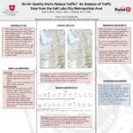
Do air quality alerts reduce traffic? An analysis of traffic data from the Salt Lake City metropolitan area
2013
Text
ir_uspace
33
Dynamics, space, and regional inequality in provincial China: a case study of Guangdong province
2012-01-01
Text
ir_uspace
34
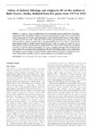
Effects of bedrock lithology and subglacial till on the motion of Ruth Glacier, Alaska, deduced from five pulses from 1973 to 2012
2014-01-01
Text
ir_uspace
35
Evaluating the effects of spatial resolution on hyperspectral fire detection and temperature retrieval
2011-08
Text
ir_etd
36
Evaluation of fire regime shifts in boreal Alaska through the use of sedimentary charcoal
2016
Text
ir_etd
37
Examining the geographic dimensions of risk perception, communication, and response during the evacuation and return-entry process
2010
Text
ir_etd
38
Examining vegetation phenology of Ugandan dambos using spectral mixture modeling fractions
2008-05
Text
ir_etd
39
Explaining the presence of perennial liquid water bodies in the firn of the Greenland Ice Sheet
2014-01-01
Text
ir_uspace
40
Exploring the use of fine resolution nested ecological niche models to identify greater sage-grouse (Centrocercus urophasianus) habitat and connectivity potential across a diverse landscape
2014-12
Text
ir_etd
41
Family gathering in evacuations: a case-study of the 2007 Angora fire
2010-08
Text
ir_etd
42
Flow instabilities of Alaskan glaciers
2014-08
Text
ir_etd
43
Flow reversal events and statistical modeling of flow dynamics of hypersaline water across a constructed causeway, Great Salt Lake, Utah, USA
2014-08
Text
ir_etd
44
Geobiology and sedimentology of the hypersaline Great Salt Lake, Northern Utah, USA: analogues for assessing watery environments on Mars?
2010
Text
ir_uspace
45
Geographic information system spatial analysis of urban and regional development in China: a case study of Guangdong Province
2014-08
Text
ir_etd
46
Geographic information system spatial-temporal evolution of multiscalar patterns and determinants of foreign direct investment in China
2014-08
Text
ir_etd
47
Geographies of climate change mitigation: an exploration of the climate change movement
2015
Text
ir_etd
48
The geography of Heber Valley
1965
Text
ir_etd
49
Geomorphic and hazard vulnerability assessment of recent residential developments on landslide-prone terrain: the case of the Traverse Mountains, Utah, USA
2010
Text
ir_uspace
50
Geomorphic evolution of pleistocene Lake Bonneville: temporal implications for surface processes on Mars
2010
Text
ir_uspace
26
-
50
of
127
<
1
2
3
4
5
6
>