Home
Browse
Ask Us
Chat
Harmful Language Statement
Log in
Advanced Search
Year
1872
1873
1874
1875
1876
1877
1878
1879
1880
1881
1882
1883
1884
1885
1886
1887
1888
1889
1890
1891
1892
1893
1894
1895
1896
1897
1898
1899
1900
1901
1902
1903
1904
1905
1906
1907
1908
1909
1910
1911
1912
1913
1914
1915
1916
1917
1918
1919
1920
1921
1922
1923
1924
1925
1926
1927
1928
1929
1930
1931
1932
1933
1934
1935
1936
1937
1938
1939
1940
1941
1942
1943
1944
1945
1946
1947
1948
1949
1950
1951
1952
1953
1954
1955
1956
1957
1958
1959
1960
1961
1962
1963
1964
1965
1966
1967
1968
1969
1970
1971
1972
1973
1974
1975
1976
1977
1978
1979
1980
1981
1982
1983
1984
1985
1986
1987
1988
1989
1990
1991
1992
1993
TO
1872
1873
1874
1875
1876
1877
1878
1879
1880
1881
1882
1883
1884
1885
1886
1887
1888
1889
1890
1891
1892
1893
1894
1895
1896
1897
1898
1899
1900
1901
1902
1903
1904
1905
1906
1907
1908
1909
1910
1911
1912
1913
1914
1915
1916
1917
1918
1919
1920
1921
1922
1923
1924
1925
1926
1927
1928
1929
1930
1931
1932
1933
1934
1935
1936
1937
1938
1939
1940
1941
1942
1943
1944
1945
1946
1947
1948
1949
1950
1951
1952
1953
1954
1955
1956
1957
1958
1959
1960
1961
1962
1963
1964
1965
1966
1967
1968
1969
1970
1971
1972
1973
1974
1975
1976
1977
1978
1979
1980
1981
1982
1983
1984
1985
1986
1987
1988
1989
1990
1991
1992
1993
Type
Image
3,521
Image/StillImage
143
Format
image/jpeg
3,594
application/pdf
70
Collection
Photo Archives
3,521
UAIDA Main Collection
143
Filters:
Collection Name:
"Herbert E. Gregory"
726
-
750
of
3,664
<
25
26
27
28
29
30
31
32
33
34
>
Gallery view
Number of results to display per page
10
25
50
100
200
Sort by Relevance
Sort by Title A-Z
Sort by Title Z-A
Sort by Date Ascending
Sort by Date Descending
Sort by Last Modified Ascending
Sort by Last Modified Descending
Title
Date
Type
Setname
726
Cliff, LaPlata on Dolores at mouth of Sagy at Sosi canyon, Ariz., 1910 (Photo G166)
1910
Image
uum_map
727
Cliff, LaPlata on Dolores at mouth of Sagy at Sosi canyon, AZ. 1910 (Photo G166)
1910
Image
uum_map
728
Cliff-vein in Canyon de Chelly, 1910.
1910
Image
uum_map
729
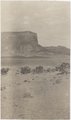
Cliffs (Dolores strata) east of Little Colorado at Tolchaco, Arizona, 1909 (photo G-88)
1909
Image
uum_map
730
Cliffs at Cannonville. Banded muds below Dakota. Lower Wahweap of Moore. Kane County, UT. 1922
1922
Image
uum_map
731
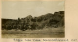
Cliffs at Lyon's Ranch, near Tuba, Ariz. Lower La Plata or upper Dolores strata, M. R. Campbell photo, 1909
1909
Image
uum_map
732
Cliffs near Tuba, Moencopie Wash, 1900
1900
Image
uum_map
733
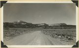
Cliffs north of highway west of Bicknell (right center). Moenkopi, Shinarump, Chinle, Wingate. Plain in foreground borders Fremont River. Wayne County, UT, 1936
1936
Image
uum_map
734
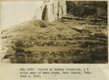
Cliffs of McElmo formation 2+ miles east of Warm Creek, Kane County, Utah. June 8, 1915.
1915
Image
uum_map
735
Cliffs of Tertiary limestone under rim of Paunsaugunt Plateau at a point about 7 miles NE of Alton, Kane County, Utah, in 1922.
1922
Image
uum_map
736
Cliffs of Waweap capped with Dakota. East side Dry Valley looking North. Top of Kaiparowits Plateau in distance. Kane County, UT. 1924
1924
Image
uum_map
737
Cliffs on north side of Navaho Mountain
1913
Image
uum_map
738
Cliffs west of Cornfields, south of Ganado; on west side of Pueblo Colorado Wash. Heald, 1911 (Photo N-M123)
1911
Image
uum_map
739
Cliffs, mouth of Parunuweap, Utah, 1936.
1936
Image
uum_map
740
Coal beds just above Morrison Dakota contact (in shadow) 2± miles north of Cannonville, Utah, 1932.
1932
Image
uum_map
741
Coal beds just above Morrison Dakota contact (in shadow) 2± miles north of Cannonville, Utah, 1932.
1932
Image
uum_map
742
Coal in the Dakota or basal Tropic; Coal hill east side Meadow Brook. Kane County, UT
1937
Image
uum_map
743
Coalpits volcano north of Grafton.
1930; 1931; 1932; 1933; 1934; 1935; 1936; 1937
Image
uum_map
744
Coast near mouth of Waimanu Valley, Hawaii, 1926 [1]
1926
Image
uum_map
745
Coast near mouth of Waimanu Valley, Hawaii, 1926 [2]
1926
Image
uum_map
746
Coast of Tahiti showing reef. Moorea in distance, 1915
1915
Image
uum_map
747
Coast of Tahiti, 1915
1915
Image
uum_map
748
Coast, Fowlers Bay, South Australia, 1916
1916
Image
uum_map
749
Coast, Fowlers Bay, South Australia, 1916
1916
Image
uum_map
750
Coconino (?) sandstone near head of Hammond Canyon. San Juan County, UT, 1927
1927
Image
uum_map
726
-
750
of
3,664
<
25
26
27
28
29
30
31
32
33
34
>