Home
Browse
Ask Us
Chat
Harmful Language Statement
Log in
Advanced Search
Year
1872
1873
1874
1875
1876
1877
1878
1879
1880
1881
1882
1883
1884
1885
1886
1887
1888
1889
1890
1891
1892
1893
1894
1895
1896
1897
1898
1899
1900
1901
1902
1903
1904
1905
1906
1907
1908
1909
1910
1911
1912
1913
1914
1915
1916
1917
1918
1919
1920
1921
1922
1923
1924
1925
1926
1927
1928
1929
1930
1931
1932
1933
1934
1935
1936
1937
1938
1939
1940
1941
1942
1943
1944
1945
1946
1947
1948
1949
1950
1951
1952
1953
1954
1955
1956
1957
1958
1959
1960
1961
1962
1963
1964
1965
1966
1967
1968
1969
1970
1971
1972
1973
1974
1975
1976
1977
1978
1979
1980
1981
1982
1983
1984
1985
1986
1987
1988
1989
1990
1991
1992
1993
TO
1872
1873
1874
1875
1876
1877
1878
1879
1880
1881
1882
1883
1884
1885
1886
1887
1888
1889
1890
1891
1892
1893
1894
1895
1896
1897
1898
1899
1900
1901
1902
1903
1904
1905
1906
1907
1908
1909
1910
1911
1912
1913
1914
1915
1916
1917
1918
1919
1920
1921
1922
1923
1924
1925
1926
1927
1928
1929
1930
1931
1932
1933
1934
1935
1936
1937
1938
1939
1940
1941
1942
1943
1944
1945
1946
1947
1948
1949
1950
1951
1952
1953
1954
1955
1956
1957
1958
1959
1960
1961
1962
1963
1964
1965
1966
1967
1968
1969
1970
1971
1972
1973
1974
1975
1976
1977
1978
1979
1980
1981
1982
1983
1984
1985
1986
1987
1988
1989
1990
1991
1992
1993
Type
Image
3,521
Image/StillImage
143
Format
image/jpeg
3,594
application/pdf
70
Collection
Photo Archives
3,521
UAIDA Main Collection
143
Filters:
Collection Name:
"Herbert E. Gregory"
626
-
650
of
3,664
<
21
22
23
24
25
26
27
28
29
30
>
Gallery view
Number of results to display per page
10
25
50
100
200
Sort by Relevance
Sort by Title A-Z
Sort by Title Z-A
Sort by Date Ascending
Sort by Date Descending
Sort by Last Modified Ascending
Sort by Last Modified Descending
Title
Date
Type
Setname
626
Carrizo Mt. looking 50° W at south side of Tse-lagai canyon. Wingate member of Navaho sandstone, conformably overlying Chinlee shale. Dip 15 degrees W
1913
Image
uum_map
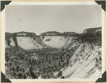
627
Carrizo Mt. looking due west at amphitheater-like gulch on east side of Carrizo Mt. and south of Chejin-Dezah Canyon
1913
Image
uum_map
628
Carrizo Mt. looking S 30° E at west end of Chejin-Dezah Mesa. Shows cirque-like basins in monsonite cliff
1913
Image
uum_map
629
Cascade Falls, source of Virgin River. Point of emergence from Wasatch limestone. Garfield County, Utah, 1937.
1937
Image
uum_map
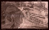
630
Castle Butte near mouth of Red Canyon Wingate on Chinle (showing details of Chinle beds); surrounding surface Shinarump, Zeke Johnson. San Juan County, UT, 1927
Image
uum_map
631
Castle Butte near mouth of Red Canyon Wingate on Chinle; surrounding surface Shinarump, Zeke Johnson. San Juan County, UT, 1927
1927
Image
uum_map
632
Castle Butte near mouth of Red Canyon Wingate on Chinle; surrounding surface Shinarump, Zeke Johnson. San Juan County, UT, 1927
1927
Image
uum_map
633
Castle uplift east flank, Navajo sandstone, San Juan County, UT, 1925
1925
Image
uum_map
634
Castle uplift east flank, Navajo sandstone, San Juan County, UT, 1925
1925
Image
uum_map
635
Castle uplift east flank, Navajo sandstone, San Juan County, UT, 1925
1925
Image
uum_map
636
Casto Bluff head of Casto Canyon southwest edge of Sevier Plateau. Acidic lava underlain by Sevier(?) formation, Garfield County, UT, 1941
1941
Image
uum_map
637
Casto Bluff, detail thick lava beds in Sevier(?) formation
1941
Image
uum_map
638
Castro Bluff, detail pumice conglomerate in Sevier formation
1941
Image
uum_map
639
Castro Bluff, detail thin beds (upper) in Sevier(?) formation
1941
Image
uum_map
640
Castro Bluff, view looking westward from its base. Terrace developed in the Sevier(?) formation at the top of the Wasatch formation
1941
Image
uum_map
641
Cathedral Arch I. Arch Canyon
1920; 1921; 1922; 1923; 1924; 1925; 1926; 1927; 1928; 1929; 1930
Image
uum_map
642
Cathedral Arch I. Arch Canyon
1920; 1921; 1922; 1923; 1924; 1925; 1926; 1927; 1928; 1929; 1930
Image
uum_map
643
Cathedral Arch II, Arch Canyon, Coconino over Supai
1920; 1921; 1922; 1923; 1924; 1925; 1926; 1927; 1928; 1929; 1930
Image
uum_map
644
Cathedral Arch II, Arch Canyon, Coconino over Supai
1920; 1921; 1922; 1923; 1924; 1925; 1926; 1927; 1928; 1929; 1930
Image
uum_map
645
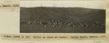
Cattle on floor of crater, Parker Ranch, Hawaii, 1926
1926
Image
uum_map
646
Cave Canyon walls of Navajo sandstone, above them shale and Temple Cap member forms second cliff, capped in turn with Carmel limestone. Zion National Park
1937; 1938
Image
uum_map
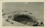
647
Cave in Navajo sandstone east slope Comb monocline in Butler Wash, 11 miles from mouth. San Juan County, UT, 1928
Image
uum_map
648
Cave in Navajo sandstone east slope Comb monocline in Butler Wash, 11 miles from mouth. San Juan County, UT, 1928
1928
Image
uum_map
649
Cave in Navajo sandstone east slope Comb monocline in Butler Wash, 11 miles from mouth. San Juan County, UT, 1928
1928
Image
uum_map
650
Cave Lakes Canyon, 1936
1936
Image
uum_map
626
-
650
of
3,664
<
21
22
23
24
25
26
27
28
29
30
>