Home
Browse
Ask Us
Chat
Harmful Language Statement
Log in
Advanced Search
Year
1872
1873
1874
1875
1876
1877
1878
1879
1880
1881
1882
1883
1884
1885
1886
1887
1888
1889
1890
1891
1892
1893
1894
1895
1896
1897
1898
1899
1900
1901
1902
1903
1904
1905
1906
1907
1908
1909
1910
1911
1912
1913
1914
1915
1916
1917
1918
1919
1920
1921
1922
1923
1924
1925
1926
1927
1928
1929
1930
1931
1932
1933
1934
1935
1936
1937
1938
1939
1940
1941
1942
1943
1944
1945
1946
1947
1948
1949
1950
1951
1952
1953
1954
1955
1956
1957
1958
1959
1960
1961
1962
1963
1964
1965
1966
1967
1968
1969
1970
1971
1972
1973
1974
1975
1976
1977
1978
1979
1980
1981
1982
1983
1984
1985
1986
1987
1988
1989
1990
1991
1992
1993
TO
1872
1873
1874
1875
1876
1877
1878
1879
1880
1881
1882
1883
1884
1885
1886
1887
1888
1889
1890
1891
1892
1893
1894
1895
1896
1897
1898
1899
1900
1901
1902
1903
1904
1905
1906
1907
1908
1909
1910
1911
1912
1913
1914
1915
1916
1917
1918
1919
1920
1921
1922
1923
1924
1925
1926
1927
1928
1929
1930
1931
1932
1933
1934
1935
1936
1937
1938
1939
1940
1941
1942
1943
1944
1945
1946
1947
1948
1949
1950
1951
1952
1953
1954
1955
1956
1957
1958
1959
1960
1961
1962
1963
1964
1965
1966
1967
1968
1969
1970
1971
1972
1973
1974
1975
1976
1977
1978
1979
1980
1981
1982
1983
1984
1985
1986
1987
1988
1989
1990
1991
1992
1993
Type
Image
3,521
Image/StillImage
143
Format
image/jpeg
3,594
application/pdf
70
Collection
Photo Archives
3,521
UAIDA Main Collection
143
Filters:
Collection Name:
"Herbert E. Gregory"
526
-
550
of
3,664
<
17
18
19
20
21
22
23
24
25
26
>
Gallery view
Number of results to display per page
10
25
50
100
200
Sort by Relevance
Sort by Title A-Z
Sort by Title Z-A
Sort by Date Ascending
Sort by Date Descending
Sort by Last Modified Ascending
Sort by Last Modified Descending
Title
Date
Type
Setname
526
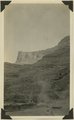
Camp in San Juan Canyon near mouth of Johns Canyon. Lower Part of wall formed by Goodridge formation and upper part by Moonlight sandstone and Hermit shale. San Juan County, UT. 1921
1921
Image
uum_map
527
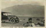
Camp near Mormon Point
1925
Image
uum_map
528
Camp near Mormon Point
1925
Image
uum_map
529
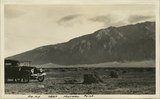
Camp on 'Lost Trail' between Jump Up Canyon and Ryan, AZ. Dr. and Mrs. Noble. Coconino County, AZ. 1922
1922
Image
uum_map
530
Camp on Navajo sandstone east of Castle uplift, San Juan County, UT, 1925
1925
Image
uum_map
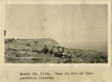
531
Camp on rim of Kaiparowitz Plateau
1922
Image
uum_map
532
Camp on rim of Kaiparowitz Plateau
1922
Image
uum_map
533
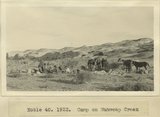
Camp on Wahweap Creek
1922
Image
uum_map
534
Camp Piute Indians, Allen Canyon, San Juan County, UT 1925
1925
Image
uum_map
535
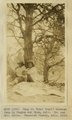
Camp scene near Allen Canyon. Piute summer shelter. Edna Hope Gregory, A.A. Baker and McKnight. San Juan County, UT, 1927
1927
Image
uum_map
536
Camp scene, 30 miles east of Escalante. Kaiparowitz Plateau in background. Dr. Noble in foreground. Kane County, UT. 1922
1922
Image
uum_map
537
Camp scene, 6 miles north of Henrieville on Henrieville Creek. Dewey Moore Packer, Garfield County, UT. 1922
1922
Image
uum_map
538
Camp scene, 6 miles north of Henrieville on Henrieville Creek. Marion Willis, packer. Garfield County, UT. 1922
1922
Image
uum_map
539
Camp scene, 6 miles north of Henrieville on Henrieville Creek. Samuel Graff Packer, Garfield County, UT. 1922
1922
Image
uum_map
540
Camp scene, south bank of Armstrong Canyon looking northeast. Camp on Coconino; plateau in middle distance. Moenkopi capped by Shinarump; mesa in left background. Chinle and Glen Canyon, Fred Lowrey. San Juan County, UT, 1928
Image
uum_map
541
Camp scene, south bank of Armstrong Canyon looking northeast. Camp on Coconino; plateau in middle distance. Moenkopi capped by Shinarump; mesa in left background. Chinle and Glen Canyon, Fred Lowrey. San Juan County, UT, 1928
1928
Image
uum_map
542
Camp scene. Elk Ridge near head Butte Canyon branch of arch Canyon. A.A. Baker and Edna Hope Gregory. San Juan County, UT, 1925
1925
Image
uum_map
543
Camp south edge of Elk Ridge at head of Grand Gulch, San Juan County, Utah. June, 1915.
1915
Image
uum_map
544
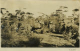
Camp Steves, dune area, South Australian desert [1]
1916
Image
uum_map
545
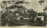
Camp Steves, dune area, South Australian desert [2]
1916
Image
uum_map
546
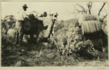
Camp Steves, dune area, South Australian desert [3]
1916
Image
uum_map
547
Camp, Bears Ears, Elk Ridge, Utah. June, 1915.
1915
Image
uum_map
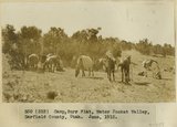
548
Camp, Burr Flat, Water Pocket Valley, Garfield County, Utah, June, 1915.
1915
Image
uum_map
549
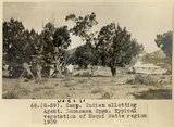
Camp, Indian allotting agent, Lucasaca Spgs. Typical vegetation of Moqui Butte region, 1909 (photo G-59)
1909
Image
uum_map
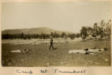
550
Camp, Mt. Trumbull
1900
Image
uum_map
526
-
550
of
3,664
<
17
18
19
20
21
22
23
24
25
26
>