|
|
Creator | Title | Description | Subject | Date |
| 1 |
 |
Gregory, Joan M. | Building sustainable partnerships: libraries as partners in creating and supporting campus green teams | Libraries as Partners in Creating and Supporting Campus Green Teams | Green teams; Sustainabliity, Recycling; Waste reduction | 2014-07-11 |
| 2 |
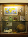 |
Paiva, Marie | Charles Darwin Library Exhibit | Photograph of a display case in the Marriott Library highlighting the anniversary of Charles Darwin's 200th birthday. | Charles Darwin birthday | 2009 |
| 3 |
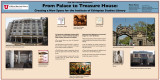 |
Paiva, Marie | From palace to treasure house: creating a new space for the Institute of Ethiopian Studies LIbrary | The Institute of Ethiopian Studies (IES) Library is a research library located at Addis Ababa University in Ethiopia. Hope arrived in 2009 when construction began for a new IES library. | Ethiopia; Research libraries; American Library Association annual conference | 2011 |
| 4 |
 |
Sorensen, Justin Bruce | Georeferenced Salt Lake City Sanborn, 1898: sheet 067 (.kmz file) | This .kmz file contains a georeferenced sheet overlay from the Sanborn Fire Insurance Maps for Salt Lake City Sanborn, 1898. The downloaded .kmz file is accessible for viewing in Google Earth and other GIS software systems. Multiple .kmz files can be loaded into a GIS software system in order to vi... | data modeling; GIS; ArcGIS; Google Earth; historic GIS | 2013 |
| 5 |
|
Sorensen, Justin Bruce | Georeferenced American Fork, 1890: sheet 01 (.kmz file) | This .kmz file contains a georeferenced sheet overlay from the Sanborn Fire Insurance Maps for American Fork, 1890. The downloaded .kmz file is accessible for viewing in Google Earth and other GIS software systems. Multiple .kmz files can be loaded into a GIS software system in order to view a cont... | data modeling; GIS; ArcGIS; Google Earth; historic GIS | 2013 |
| 6 |
|
Sorensen, Justin Bruce | Georeferenced American Fork, 1890: sheet 02 (.kmz file) | This .kmz file contains a georeferenced sheet overlay from the Sanborn Fire Insurance Maps for American Fork, 1890. The downloaded .kmz file is accessible for viewing in Google Earth and other GIS software systems. Multiple .kmz files can be loaded into a GIS software system in order to view a cont... | data modeling; GIS; ArcGIS; Google Earth; historic GIS | 2013 |
| 7 |
|
Sorensen, Justin Bruce | Georeferenced American Fork, 1890: sheet 03 (.kmz file) | This .kmz file contains a georeferenced sheet overlay from the Sanborn Fire Insurance Maps for American Fork, 1890. The downloaded .kmz file is accessible for viewing in Google Earth and other GIS software systems. Multiple .kmz files can be loaded into a GIS software system in order to view a cont... | data modeling; GIS; ArcGIS; Google Earth; historic GIS | 2013 |
| 8 |
|
Sorensen, Justin Bruce | Georeferenced American Fork, 1890: sheet 04 (.kmz file) | This .kmz file contains a georeferenced sheet overlay from the Sanborn Fire Insurance Maps for American Fork, 1890. The downloaded .kmz file is accessible for viewing in Google Earth and other GIS software systems. Multiple .kmz files can be loaded into a GIS software system in order to view a cont... | data modeling; GIS; ArcGIS; Google Earth; historic GIS | 2013 |
| 9 |
|
Sorensen, Justin Bruce | Georeferenced American Fork, 1890: sheet 05 (.kmz file) | This .kmz file contains a georeferenced sheet overlay from the Sanborn Fire Insurance Maps for American Fork, 1890. The downloaded .kmz file is accessible for viewing in Google Earth and other GIS software systems. Multiple .kmz files can be loaded into a GIS software system in order to view a cont... | data modeling; GIS; ArcGIS; Google Earth; historic GIS | 2013 |
| 10 |
|
Sorensen, Justin Bruce | Georeferenced American Fork, 1890: sheet 06 (.kmz file) | This .kmz file contains a georeferenced sheet overlay from the Sanborn Fire Insurance Maps for American Fork, 1890. The downloaded .kmz file is accessible for viewing in Google Earth and other GIS software systems. Multiple .kmz files can be loaded into a GIS software system in order to view a cont... | data modeling; GIS; ArcGIS; Google Earth; historic GIS | 2013 |
| 11 |
|
Sorensen, Justin Bruce | Georeferenced American Fork, 1908: sheet 01 (.kmz file) | This .kmz file contains a georeferenced sheet overlay from the Sanborn Fire Insurance Maps for American Fork, 1908. The downloaded .kmz file is accessible for viewing in Google Earth and other GIS software systems. Multiple .kmz files can be loaded into a GIS software system in order to view a cont... | data modeling; GIS; ArcGIS; Google Earth; historic GIS | 2013 |
| 12 |
|
Sorensen, Justin Bruce | Georeferenced American Fork, 1908: sheet 02 (.kmz file) | This .kmz file contains a georeferenced sheet overlay from the Sanborn Fire Insurance Maps for American Fork, 1908. The downloaded .kmz file is accessible for viewing in Google Earth and other GIS software systems. Multiple .kmz files can be loaded into a GIS software system in order to view a cont... | data modeling; GIS; ArcGIS; Google Earth; historic GIS | 2013 |
| 13 |
|
Sorensen, Justin Bruce | Georeferenced American Fork, 1908: sheet 03 (.kmz file) | This .kmz file contains a georeferenced sheet overlay from the Sanborn Fire Insurance Maps for American Fork, 1908. The downloaded .kmz file is accessible for viewing in Google Earth and other GIS software systems. Multiple .kmz files can be loaded into a GIS software system in order to view a cont... | data modeling; GIS; ArcGIS; Google Earth; historic GIS | 2013 |
| 14 |
|
Sorensen, Justin Bruce | Georeferenced American Fork, 1908: sheet 04 (.kmz file) | This .kmz file contains a georeferenced sheet overlay from the Sanborn Fire Insurance Maps for American Fork, 1908. The downloaded .kmz file is accessible for viewing in Google Earth and other GIS software systems. Multiple .kmz files can be loaded into a GIS software system in order to view a cont... | data modeling; GIS; ArcGIS; Google Earth; historic GIS | 2013 |
| 15 |
|
Sorensen, Justin Bruce | Georeferenced American Fork, 1908: sheet 05 (.kmz file) | This .kmz file contains a georeferenced sheet overlay from the Sanborn Fire Insurance Maps for American Fork, 1908. The downloaded .kmz file is accessible for viewing in Google Earth and other GIS software systems. Multiple .kmz files can be loaded into a GIS software system in order to view a cont... | data modeling; GIS; ArcGIS; Google Earth; historic GIS | 2013 |
| 16 |
|
Sorensen, Justin Bruce | Georeferenced American Fork, 1908: sheet 06 (.kmz file) | This .kmz file contains a georeferenced sheet overlay from the Sanborn Fire Insurance Maps for American Fork, 1908. The downloaded .kmz file is accessible for viewing in Google Earth and other GIS software systems. Multiple .kmz files can be loaded into a GIS software system in order to view a cont... | data modeling; GIS; ArcGIS; Google Earth; historic GIS | 2013 |
| 17 |
|
Sorensen, Justin Bruce | Georeferenced American Fork, 1908: sheet 07 (.kmz file) | This .kmz file contains a georeferenced sheet overlay from the Sanborn Fire Insurance Maps for American Fork, 1908. The downloaded .kmz file is accessible for viewing in Google Earth and other GIS software systems. Multiple .kmz files can be loaded into a GIS software system in order to view a cont... | data modeling; GIS; ArcGIS; Google Earth; historic GIS | 2013 |
| 18 |
|
Sorensen, Justin Bruce | Georeferenced American Fork, 1908: sheet 08 (.kmz file) | This .kmz file contains a georeferenced sheet overlay from the Sanborn Fire Insurance Maps for American Fork, 1908. The downloaded .kmz file is accessible for viewing in Google Earth and other GIS software systems. Multiple .kmz files can be loaded into a GIS software system in order to view a cont... | data modeling; GIS; ArcGIS; Google Earth; historic GIS | 2013 |
| 19 |
|
Sorensen, Justin Bruce | Georeferenced Beaver Sanborn, 1917: sheet 01 (.kmz file) | This .kmz file contains a georeferenced sheet overlay from the Sanborn Fire Insurance Maps for Beaver Sanborn, 1917. The downloaded .kmz file is accessible for viewing in Google Earth and other GIS software systems. Multiple .kmz files can be loaded into a GIS software system in order to view a con... | data modeling; GIS; ArcGIS; Google Earth; historic GIS | 2013 |
| 20 |
|
Sorensen, Justin Bruce | Georeferenced Beaver Sanborn, 1917: sheet 02 (.kmz file) | This .kmz file contains a georeferenced sheet overlay from the Sanborn Fire Insurance Maps for Beaver Sanborn, 1917. The downloaded .kmz file is accessible for viewing in Google Earth and other GIS software systems. Multiple .kmz files can be loaded into a GIS software system in order to view a con... | data modeling; GIS; ArcGIS; Google Earth; historic GIS | 2013 |
| 21 |
|
Sorensen, Justin Bruce | Georeferenced Beaver Sanborn, 1917: sheet 03 (.kmz file) | This .kmz file contains a georeferenced sheet overlay from the Sanborn Fire Insurance Maps for Beaver Sanborn, 1917. The downloaded .kmz file is accessible for viewing in Google Earth and other GIS software systems. Multiple .kmz files can be loaded into a GIS software system in order to view a con... | data modeling; GIS; ArcGIS; Google Earth; historic GIS | 2013 |
| 22 |
|
Sorensen, Justin Bruce | Georeferenced Beaver Sanborn, 1917: sheet 04 (.kmz file) | This .kmz file contains a georeferenced sheet overlay from the Sanborn Fire Insurance Maps for Beaver Sanborn, 1917. The downloaded .kmz file is accessible for viewing in Google Earth and other GIS software systems. Multiple .kmz files can be loaded into a GIS software system in order to view a con... | data modeling; GIS; ArcGIS; Google Earth; historic GIS | 2013 |
| 23 |
|
Sorensen, Justin Bruce | Georeferenced Brigham City 1884: sheet 01 (.kmz file) | This .kmz file contains a georeferenced sheet overlay from the Sanborn Fire Insurance Maps for Brigham City, 1884. The downloaded .kmz file is accessible for viewing in Google Earth and other GIS software systems. Multiple .kmz files can be loaded into a GIS software system in order to view a conti... | data modeling; GIS; ArcGIS; Google Earth; historic GIS | 2013 |
| 24 |
|
Sorensen, Justin Bruce | Georeferenced Brigham City, 1884: sheet 02 (.kmz file) | This .kmz file contains a georeferenced sheet overlay from the Sanborn Fire Insurance Maps for Brigham City, 1884. The downloaded .kmz file is accessible for viewing in Google Earth and other GIS software systems. Multiple .kmz files can be loaded into a GIS software system in order to view a conti... | data modeling; GIS; ArcGIS; Google Earth; historic GIS | 2013 |
| 25 |
|
Sorensen, Justin Bruce | Georeferenced Brigham City, 1884: sheet 03 (.kmz file) | This .kmz file contains a georeferenced sheet overlay from the Sanborn Fire Insurance Maps for Brigham City, 1884. The downloaded .kmz file is accessible for viewing in Google Earth and other GIS software systems. Multiple .kmz files can be loaded into a GIS software system in order to view a conti... | data modeling; GIS; ArcGIS; Google Earth; historic GIS | 2013 |