Filters: Department: "Materials Science & Engineering" School Or College: "College of Mines & Earth Sciences"
| Title | Date | Type | Setname | ||
|---|---|---|---|---|---|
| 26 |
 |
Petrogeneis of the Mineral Range Pluton, Southwestern Utah: Georeferenced map files | 1960-06 | Image | ir_etd |
| 27 |
 |
Plate 1: Lucin mining district and vicinity, Northern Pilot Range, Box Elder County, Utah - Elko County, Nevada (Google Earth map overlay KMZ file) | 1960-08 | Image | ir_etd |
| 28 |
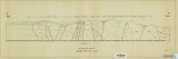 |
Plate 2: Cross-section A-A' | 1959-06 | Image | ir_etd |
| 29 |
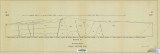 |
Plate 3: Cross-section B-B' | 1959-06 | Image | ir_etd |
| 30 |
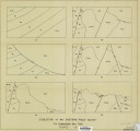 |
Plate 4: Evolution of the eastern fault block | 1959-06 | Image | ir_etd |
| 31 |
|
Plates 2-3 Geologic map of the Mount Ogden granite, Weber County, Utah and Geologic sections to accompany the Geologic map of the Mount Ogden granite, Weber County, Utah (Google Earth map overlay KMZ file) | 1969-06 | Image | ir_etd |
| 32 |
 |
Structural complexity in CU-SN molten alloys by Stirred H-cell emf measurements | 1973 | Text | ir_htca |
| 33 |
 |
Synthesis of metal borides for insensitive energetic fuels | 2012-05 | Text | ir_htca |