Home
Browse
Ask Us
Chat
Harmful Language Statement
Log in
Institutional Repository
Advanced Search
Year
1998
1999
2000
2001
2002
2003
2004
2005
2006
2007
2008
2009
2010
2011
2012
2013
2014
2015
2016
2017
2018
TO
1998
1999
2000
2001
2002
2003
2004
2005
2006
2007
2008
2009
2010
2011
2012
2013
2014
2015
2016
2017
2018
Type
Text
14
InteractiveResource
2
Format
application/pdf
16
Collection
Theses & Dissertations
13
UScholar Works
2
Undergraduate Works
1
Filters:
Subject:
"Remote sensing"
1
-
25
of
16
Gallery view
Number of results to display per page
10
25
50
100
200
Sort by Relevance
Sort by Title A-Z
Sort by Title Z-A
Sort by Date Ascending
Sort by Date Descending
Sort by Last Modified Ascending
Sort by Last Modified Descending
Title
Date
Type
Setname
1
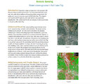
Remote sensing: green coverage area in Salt Lake City
InteractiveResource
ir_etd
2
Forward electromagnetic scattering models for sea ice
1998
Text
ir_uspace
3
Inverse electromagnetic scattering models for sea ice
1998
Text
ir_uspace
4
Cirrus particle size distribution bimodality derived from ground-based radar-lidar retrievals
2011-05
Text
ir_etd
5
A paleolimnological investigation of historical environmental change in East Canyon Reservoir
2011-05
Text
ir_etd
6
Recent trends in the changing geographic extent of Cienegas of the United States/Mexico border region
2011-05
Text
ir_etd
7
Evaluating the effects of spatial resolution on hyperspectral fire detection and temperature retrieval
2011-08
Text
ir_etd
8
Mapping and spatial-temporal modeling of Bromus tectorum invasion in Central Utah
2011-11
Text
ir_etd
9
Ice flow dynamics of Alaska glaciers
2013-05
Text
ir_etd
10
A rangeland predictive phenological model for the upper Colorado River Basin and its web delivery
2013-08
Text
ir_etd
11
Impacts of topographic shading on surface energy balance of High Mountain Asia glaciers
2017
Text
ir_etd
12
Quantifying drought-induced changes in green vegetation fraction and classification accuracy using hyperspectral data for the Central Sierra Nevada, California
2017
Text
ir_etd
13
Master of Geographic Information Science Portfolio
2017
InteractiveResource
ir_etd
14
Remote sensing and geospatial modeling of wildland firefighter safety
2018
Text
ir_etd
15
Using an optimal estimation algorithm to describe the mass-dimensional properties of ice clouds
2018
Text
ir_etd
16
Remote sensing data products to investigate relationships between Great Salt Lake surface area, watershed precipitation, and air quality
2018
Text
ir_uw
1
-
25
of
16