Home
Browse
Ask Us
Chat
Harmful Language Statement
Log in
Institutional Repository
Advanced Search
Year
1961
1962
1963
1964
1965
1966
1967
1968
1969
1970
1971
1972
1973
1974
1975
1976
1977
1978
1979
1980
1981
1982
1983
1984
1985
1986
1987
1988
1989
1990
1991
1992
1993
1994
1995
1996
1997
1998
1999
2000
2001
2002
2003
2004
2005
2006
2007
2008
2009
2010
2011
2012
2013
2014
2015
2016
TO
1961
1962
1963
1964
1965
1966
1967
1968
1969
1970
1971
1972
1973
1974
1975
1976
1977
1978
1979
1980
1981
1982
1983
1984
1985
1986
1987
1988
1989
1990
1991
1992
1993
1994
1995
1996
1997
1998
1999
2000
2001
2002
2003
2004
2005
2006
2007
2008
2009
2010
2011
2012
2013
2014
2015
2016
Type
Text
7
Image
4
Format
application/pdf
16
Collection
Electronic University Archive
9
Theses & Dissertations
7
Filters:
Publication Type:
"map"
Format:
"application/pdf"
1
-
25
of
16
Gallery view
Number of results to display per page
10
25
50
100
200
Sort by Relevance
Sort by Title A-Z
Sort by Title Z-A
Sort by Date Ascending
Sort by Date Descending
Sort by Last Modified Ascending
Sort by Last Modified Descending
Title
Date
Type
Setname
1
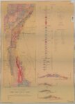
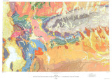
Geologic map and sections of the Cherry Creek District, Nevada
1961
ir_etd
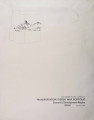
2
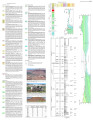
Torrey Plate 2
2016
Text
ir_etd
3
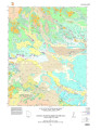
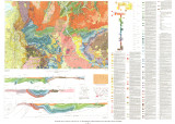
Geologic map of the Torrey Quadrangle, Wayne County, Utah
2016
Text
ir_etd
4
Torrey Plate 1
2016
Text
ir_etd
5
2011 Group Ticket Pricing (UUSAC)
2011
Image
ir_eua
6
Oil-impregnated rock deposits of Utah
1974-07
ir_eua
7
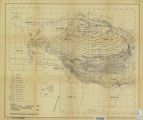
Preliminary location map oil-impregnated rock deposits of Utah
1968-04
ir_eua
8
Energy resources map of Utah (no. 44)
1974
ir_eua
9
Energy resources map of Utah (no. 36)
1975-05-01
ir_eua
10
Plate 1: Geologic map of the Lothidok Range, Kenya
1988-08
Image
ir_etd
11
Geologic and structure maps of the Salt Lake City 1º X 2º quadrangle, Utah and Wyoming
1992
Text
ir_eua
12
Geologic map of the Salt Lake City 30' X 60' quadrangle, north-central Utah, and Uinta County, Wyoming
1990
Text
ir_eua
13
Transportation system map portfolio
1969-12
Text
ir_eua
14
Energy resources map of Utah (no. 68)
1983-05
Text
ir_eua
15
Subsurface stratigraphy of the Wasatch Formation of the Uinta Basin, Utah (Maps)
1963-05
Image
ir_etd
16
Geology of the Terrace and Hogup Mountains, Box Elder County, Utah (Maps)
1964-06
Image
ir_etd
1
-
25
of
16