TO
Filters: School Or College: "University of Utah" Collection: "ir_eua" Subject: "Green River Formation"
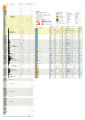
| Title | Date | Subject | Description | ||
|---|---|---|---|---|---|
| 1 |
 |
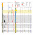
Asphalt Wash 1 (U086) - Plate 9 | 2014 | Green River Formation; well log; core log; Asphalt Wash 1; plate 9 | |
| 2 |
 |
EX-1 Plate 3 | 2014 | plate 3; well log; Green River Formation; core log | |
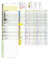
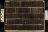
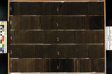
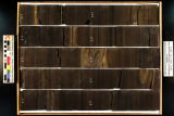
| 3 |
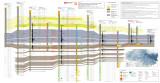 |
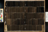
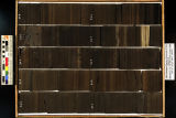
North-South core-based cross section through the middle to upper Green River Formation, Uinta Basin, Utah - Plate 2 | 2014 | oil shale; economic oil shale; oil shale zone; cross section; Green River Formation; well log; core log | The top of economic oil shale was picked at the top of the lower R-8 zone (top of the Big Three rich oil shale beds). This zone was selected to avoid the abundant saline minerals found in the overlaying saline zone, which often contains high-TDS water. If saline minerals (and high-TDS water) do not ... |
| 4 |
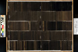
 |
P4 Plate 6 | 2014 | well log; core log; plate 6; P4; White River Shale Project; Green River Formation | |
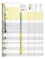
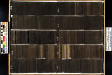
| 5 |
 |
QEMSCAN analysis of Green River Formation oil shale samples, Skyline 16 core, eastern Uinta basin, UT | 2014 | QEMSCAN; oil shale; Green River Formation; Skyline 16 core; minerology | Conclusions in the presentations: 1. QEMscan analysis reveals mineralogic textures dominated by dolomite, illite, and calcite. 2. A few interpretations are made in regards to the documented compositional results generated automatically by the QEMscan: "Background" is assumed to reflect organic matt... |
| 6 |
 |
Red Wash 1 (U045) - Plate 8 | 2014 | plate 8; Red Wash 1; well log; core log; Green River Formation | |
| 7 |
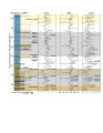 |
Redwash 1 XRF depth plots | 2014 | depth plots; Green River Formation; XRF | |
| 8 |
 |
Skyline 16 - Plate 7 | 2014 | well log; core log; Skyline 16; plate 7; Green River Formation | |
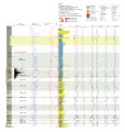
| 9 |
 |
Skyline 16 information | 2015-07 | Skyline 16; preliminary stratigraphy of Skyline 16; Green River Formation; Protecore samples | |
| 10 |
 |
Skyline 16: SW SW sec. 10 11S 25E Uintah County, Utah. Box 21 Depth: 220.0 - 230.0 ft. | 2015-07 | core samples; Skyline 16; box 21; Green River Formation | Core sample photograph by the Utah Geological Survey at the University of Utah and the Utah Core Research Center. Skyline 16: SW SW sec. 10 11S 25E Uintah County, Utah. Box 21 Depth: 220.0 - 230.0 ft. |
| 11 |
 |
Skyline 16: SW SW sec. 10 11S 25E Uintah County, Utah. Box 22 Depth: 230.0 - 240.0 ft. | 2015-07 | core samples; Skyline 16; box 22; Green River Formation | Core sample photograph by the Utah Geological Survey at the University of Utah, and the Utah Core Research Center. Skyline 16: SW SW sec. 10 11S 25E Uintah County, Utah. Box 22 Depth: 230.0 - 240.0 ft. |
| 12 |
 |
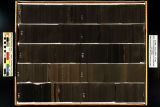
Skyline 16: SW SW sec. 10 11S 25E Uintah County, Utah. Box 23 Depth: 240.0 - 250.0 ft. | 2015-07 | core samples; Skyline 16; box 23; Green River Formation | Core sample photograph by the Utah Geological Survey at the University of Utah, and the Utah Core Research Center. Skyline 16: SW SW sec. 10 11S 25E Uintah County, Utah. Box 23 Depth: 240.0 - 250.0 ft. |
| 13 |
 |
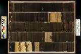
Skyline 16: SW SW sec. 10 11S 25E Uintah County, Utah. Box 24 Depth: 250.0 - 260.0 ft. | 2015-07 | core samples; Skyline 16; box 24; Green River Formation | Core sample photograph by the Utah Geological Survey at the University of Utah, and the Utah Core Research Center. Skyline 16: SW SW sec. 10 11S 25E Uintah County, Utah. Box 24 Depth: 250.0 - 260.0 ft. |
| 14 |
 |
Skyline 16: SW SW sec. 10 11S 25E Uintah County, Utah. Box 25 Depth: 260.0 - 270.0 ft. | 2015-07 | core samples; Skyline 16; box 25; Green River Formation | Core sample photograph by the Utah Geological Survey and the University of Utah, and the Utah Core Research Center. Skyline 16: SW SW sec. 10 11S 25E Uintah County, Utah. Box 25 Depth: 260.0 - 270.0 ft. |
| 15 |
 |
Skyline 16: SW SW sec. 10 11S 25E Uintah County, Utah. Box 26 Depth: 270.0 - 280.0 ft. | 2015-07 | core samples; Skyline 16; box 26; Green River Formation | Core sample photograph by the Utah Geological Survey at the University of Utah, and the Utah Core Research Center. Skyline 16: SW SW sec. 10 11S 25E Uintah County, Utah. Box 26 Depth: 270.0 - 280.0 ft. |
| 16 |
 |
Skyline 16: SW SW sec. 10 11S 25E Uintah County, Utah. Box 27 Depth: 280.0 - 290.0 ft. | 2015-07 | core samples; Skyline 16; box 27; Green River Formation | Core sample photograph by the Utah Geological Survey at the University of Utah, and the Utah Core Research Center. Skyline 16: SW SW sec. 10 11S 25E Uintah County, Utah. Box 27 Depth: 280.0 - 290.0 ft. |
| 17 |
 |
Skyline 16: SW SW sec. 10 11S 25E Uintah County, Utah. Box 28 Depth: 290.0 - 300.0 ft. | 2015-07 | core samples; Skyline 16; box 28; Green River Formation | Core sample photograph by the Utah Geological Survey at the University of Utah, and the Utah Core Research Center. Skyline 16: SW SW sec. 10 11S 25E Uintah County, Utah. Box 28 Depth: 290.0 - 300.0 ft. |
| 18 |
 |
Skyline 16: SW SW sec. 10 11S 25E Uintah County, Utah. Box 29 Depth: 300.0 - 310.0 ft. | 2015-07 | core samples; Skyline 16; box 29; Green River Formation | Core sample photograph by the Utah Geological Survey at the University of Utah, and the Utah Core Research Center. Skyline 16: SW SW sec. 10 11S 25E Uintah County, Utah. Box 29 Depth: 300.0 - 310.0 ft. |
| 19 |
 |
Skyline 16: SW SW sec. 10 11S 25E Uintah County, Utah. Box 30 Depth: 310.0 - 320.0 ft. | 2015-07 | core samples; Skyline 16; box 30; Green River Formation | Core sample photograph by the Utah Geological Survey at the University of Utah, and the Utah Core Research Center. Skyline 16: SW SW sec. 10 11S 25E Uintah County, Utah. Box 30 Depth: 310.0 - 320.0 ft. |
| 20 |
 |
Skyline 16: SW SW sec. 10 11S 25E Uintah County, Utah. Box 31 Depth: 320.0 - 330.0 ft. | 2015-07 | core samples; Skyline 16; box 31; Green River Formation | Core sample photograph by the Utah Geological Survey at the University of Utah, and the Utah Core Research Center. Skyline 16: SW SW sec. 10 11S 25E Uintah County, Utah. Box 31 Depth: 320.0 - 330.0 ft. |
| 21 |
 |
Skyline 16: SW SW sec. 10 11S 25E Uintah County, Utah. Box 32 Depth: 330.0 - 340.0 ft. | 2015-07 | core samples; Skyline 16; box 32; Green River Formation | Core sample photograph by the Utah Geological Survey at the University of Utah, and the Utah Core Research Center. Skyline 16: SW SW sec. 10 11S 25E Uintah County, Utah. Box 32 Depth: 330.0 - 340.0 ft. |
| 22 |
 |
Skyline 16: SW SW sec. 10 11S 25E Uintah County, Utah. Box 33 Depth: 340.0 - 350.0 ft. | 2015-07 | core samples; Skyline 16; box 33; Green River Formation | Core sample photograph by the Utah Geological Survey at the University of Utah, and the Utah Core Research Center. Skyline 16: SW SW sec. 10 11S 25E Uintah County, Utah. Box 33 Depth: 340.0 - 350.0 ft. |
| 23 |
 |
Skyline 16: SW SW sec. 10 11S 25E Uintah County, Utah. Box 34 Depth: 350.0 - 360.0 ft. | 2015-07 | core samples; Skyline 16; box 34; Green River Formation | Core sample photograph by the Utah Geological Survey at the University of Utah, and the Utah Core Research Center. Skyline 16: SW SW sec. 10 11S 25E Uintah County, Utah. Box 34 Depth: 350.0 - 360.0 ft. |
| 24 |
 |
Skyline 16: SW SW sec. 10 11S 25E Uintah County, Utah. Box 35 Depth: 360.0 - 370.0 ft. | 2015-07 | core samples; Skyline 16; box 35; Green River Formation | Core sample photograph by the Utah Geological Survey at the University of Utah, and the Utah Core Research Center. Skyline 16: SW SW sec. 10 11S 25E Uintah County, Utah. Box 35 Depth: 360.0 - 370.0 ft. |
| 25 |
 |
Skyline 16: SW SW sec. 10 11S 25E Uintah County, Utah. Box 36 Depth: 370.0 - 380.0 ft. | 2015-07 | core samples; Skyline 16; box 36; Green River Formation | Core sample photograph by the Utah Geological Survey at the University of Utah, and the Utah Core Research Center. Skyline 16: SW SW sec. 10 11S 25E Uintah County, Utah. Box 36 Depth: 370.0 - 380.0 ft. |