Home
Browse
Ask Us
Chat
Harmful Language Statement
Log in
Institutional Repository
Advanced Search
Year
1905
1906
1907
1908
1909
1910
1911
1912
1913
1914
1915
1916
1917
1918
1919
1920
1921
1922
1923
1924
1925
1926
1927
1928
1929
1930
1931
1932
1933
1934
1935
1936
1937
1938
1939
1940
1941
1942
1943
1944
1945
1946
1947
1948
1949
1950
1951
1952
1953
1954
1955
1956
1957
1958
1959
1960
1961
1962
1963
1964
1965
1966
1967
1968
1969
1970
1971
1972
1973
1974
1975
1976
1977
1978
1979
1980
1981
1982
1983
1984
1985
1986
1987
1988
1989
1990
1991
1992
1993
1994
1995
1996
1997
1998
1999
2000
2001
2002
2003
2004
2005
2006
2007
2008
2009
2010
2011
2012
2013
2014
2015
2016
2017
2018
2019
2020
TO
1905
1906
1907
1908
1909
1910
1911
1912
1913
1914
1915
1916
1917
1918
1919
1920
1921
1922
1923
1924
1925
1926
1927
1928
1929
1930
1931
1932
1933
1934
1935
1936
1937
1938
1939
1940
1941
1942
1943
1944
1945
1946
1947
1948
1949
1950
1951
1952
1953
1954
1955
1956
1957
1958
1959
1960
1961
1962
1963
1964
1965
1966
1967
1968
1969
1970
1971
1972
1973
1974
1975
1976
1977
1978
1979
1980
1981
1982
1983
1984
1985
1986
1987
1988
1989
1990
1991
1992
1993
1994
1995
1996
1997
1998
1999
2000
2001
2002
2003
2004
2005
2006
2007
2008
2009
2010
2011
2012
2013
2014
2015
2016
2017
2018
2019
2020
Type
Text
935
Image
152
Image/StillImage
1
Format
application/pdf
973
application/vnd.google-earth.kmz
38
application/zip
36
image/jpeg
7
Collection
Electronic University Archive
2
Honors Theses Closed Archive
11
Sustainability U
2
Theses & Dissertations
764
UScholar Works
275
Filters:
School Or College:
"College of Mines & Earth Sciences"
726
-
750
of
1,054
<
25
26
27
28
29
30
31
32
33
34
>
Gallery view
Number of results to display per page
10
25
50
100
200
Sort by Relevance
Sort by Title A-Z
Sort by Title Z-A
Sort by Date Ascending
Sort by Date Descending
Sort by Last Modified Ascending
Sort by Last Modified Descending
Title
Date
Type
Setname
726
Petrology of Lake Bonneville Gravels Salt Lake County, Utah: Georeferenced map files
1963-05
Image
ir_etd
727
Petrology of the moenkopi formation (Early Triassic), Uinta Mountain Area, Northeastern Utah
1974-06
Text
ir_etd
728
Petrophysical and diagenetic characteristics of the permian white rim sandstone, southeast utah
2015-08
Text
ir_etd
729
Phase equilibria between iron and slag in CO/CO2/H2/H2O atmospheres relevant to a novel flash ironmaking technology
2013-08
Text
ir_etd
730
Phenomenological model of the hydrocyclone
1988
Text
ir_etd
731
Phosphorus removal from manganese ore by plasma treatment
2011-08
Text
ir_etd
732
Physicochemical aspects of smithsonite flotation
2014-08
Text
ir_etd
733
Pilot-plant evaluation of a water insoluble hydroxamic acid collector for single stage flotation of Florida phosphate rock
2006
Text
ir_uspace
734
Plasma-assisted chemical vapor synthesis of transparent conducting oxides and their applications as transparent conducting films
2018
Text
ir_etd
735
Plate 1 Fence diagram Moenkopi group (Google Earth map overlay KMZ file)
1969-06
Image
ir_etd
736
Plate 1 Generalized geologic map of the Laramide orogenic sediments of the Wasatch Hinterland (Google Earth map overlay KMZ file)
1974
Image
ir_etd
737
Plate 1 Geologic map of Stansbury Island, Tooele County, Utah (Google Earth map overlay KMZ file)
1969-06
Image
ir_etd
738
Plate 1 Geologic map of the Sheeprock Mountains area, Utah (Google Earth map overlay KMZ file)
1957-08
Image
ir_etd
739
Plate 1: Geologic map and vertical cross section of the Sulphurdale sulphur deposits, Beaver and Millard Counties, Utah
1960-08
Image
ir_etd
740
Plate 1: Geologic map and vertical cross section of the Sulphurdale sulphur deposits, Beaver and Millard Counties, Utah (Google Earth map overlay KMZ file)
1960-08
Image
ir_etd
741
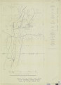
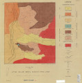
Plate 1: Geologic map of Northern Bryce Canyon National Park
1961-06
Image
ir_etd
742
Plate 1: Geologic map of the Little Willow Series, Wasatch Mountains, Utah
1962-11
Image
ir_etd
743
Plate 1: Geologic map of the Lothidok Range, Kenya
1988-08
Image
ir_etd
744
Plate 1: Geologic map of the Paria NW quadrangle, Kane County, Utah
1970-08
Image
ir_etd
745
Plate 1: Geologic map of the Southern Grouse Creek Mountains, Box Elder County, Utah (Google Earth map overlay KMZ file)
1959-06
Image
ir_etd
746
Plate 1: Geologic map of the Willard Peak area, North-Central Wasatch Mountains, Utah
1972-12
Image
ir_etd
747
Plate 1: Geologic map of the Willard Peak area, North-Central Wasatch Mountains, Utah (Google Earth map overlay KMZ file)
1972-12
Image
ir_etd
748
Plate 1: Lucin mining district and vicinity, Northern Pilot Range, Box Elder County, Utah - Elko County, Nevada (Google Earth map overlay KMZ file)
1960-08
Image
ir_etd
749
Plate 1B: Geologic map of the Central and Southern Silver Island Mountains, Box Elder and Tooele Counties, Utah, and Elko County, Nevada
1961-06
Image
ir_etd
750
Plate 1B: Geologic map of the Central and Southern Silver Island Mountains, Box Elder and Tooele Counties, Utah, and Elko County, Nevada (Google Earth map overlay KMZ file)
1961-06
Image
ir_etd
726
-
750
of
1,054
<
25
26
27
28
29
30
31
32
33
34
>