In 1853 Richard Hovendon Kern was hired as topographer and artist for a government-sponsored reconnaissance led by Captain John Williams Gunnison. Kern sketched landscape panoramas as the group made its way from St. Louis toward San Francisco. When the expedition reached Sevier Lake, Utah, however, it was attacked by a band of Indians. Seven men, including Kern and Gunnison, were killed, and Kern's drawings were stolen. The sketches were soon recovered and eventually carried to Washington, D.C.
Robert Shlaer, an accomplished daguerreotypist, came across Kern's sketches many years later at the Newberry Library in Chicago. He was inspired to locate the views depicted in the drawings and to photograph them, as nearly as was possible, from the same spot where Kern had stood when he sketched them. This collection juxtaposes Kern's drawings with Shlaer's photographs, presenting 389 illustrations in geographic sequence from east to west
Filters: Collection:"uu_rkfws"
| Title | Alternative Title | ||
|---|---|---|---|
| 201 |  | Plate 201 | Valley at the mouth of Cochetopa Pass, composite drawing and photograph. |
| 202 |  | Plate 202 | Razor Creek near its junction with Cochetopa Creek |
| 203 | 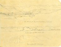 | Plate 203 | Three sketches with minimally helpful titles drawn on one sheet by Richard Kern from near Gunnison, CO, along Cochetopa (Tomichi) Creek near its junction with the Grand (today Gunnison) River. |
| 204 | 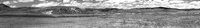 | Plate 204 | Photograph by Robert Shlaer of lower Razor Creek |
| 205 | 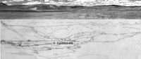 | Plate 205 | Composite sketch and photograph of the view down Razor Creek Valley as it joins Cochetopa Creek |
| 206 |  | Plate 206 | Western slopes of Sah-Watch Mts, sketch |
| 207 |  | Plate 207 | West end of Coo-che-to-pa Pass, sketch |
| 208 |  | Plate 208 | Rock outcrops, sketch |
| 209 |  | Plate 209 | Rock outcrops, photograph |
| 210 |  | Plate 210 | Rock outcrops, composite sketch and photograph |
| 211 |  | Plate 211 | View up Grand River (first mesa), sketch |
| 212 |  | Plate 212 | View up Grand River (first mesa), photograph |
| 213 |  | Plate 213 | View up Grand River (first mesa), composite sketch and photograph |
| 214 |  | Plate 214 | On Grand River, sketch |
| 215 |  | Plate 215 | On Grand River, photograph |
| 216 |  | Plate 216 | On Grand River, composite sketch and photograph |
| 217 | 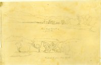 | Plate 217 | From Camp, Sept. 7th, on Grand River (two sketches) |
| 218 |  | Plate 218 | From Camp, Sept. 7th, on Grand River, sketch |
| 219 | 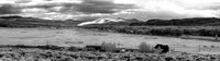 | Plate 219 | Grand River from Sept. 7th camp, photograph |
| 220 | 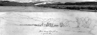 | Plate 220 | From Camp, Sept. 7th, on Grand River, composite sketch and photograph |
| 221 |  | Plate 221 | On Grand River,from Camp, Sept. 7th, sketch |
| 222 |  | Plate 222 | On Grand River,from Camp, Sept. 7th, photograph |
| 223 |  | Plate 223 | On Grand River,from Camp, Sept. 7th, composite sketch and photograph |
| 224 |  | Plate 224 | Valley of Grand River, Sept. 8th, sketch |
| 225 |  | Plate 225 | Valley of Gunnison River and Blue Mesa Reservoir, photograph |