| OCR Text |
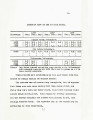
Show 13. All of the abovo mentioned otream3 havo thoir 3ource in tho high mountains north of tho project and are fod by numerous 3znnll lakes and drifted snow banks during tbs lrrl.3ss-.i0n season, whioh extends from Bay* 1 to October 1. Tha total drainage aroa for the Buchasne aad tributaries - is about 4,000 square miles and ita annual discharge about "7 7,000,000 aero feet. Bue to the meLting snow, tha rivers reach their peak about June 20th; thc^r then diminish until about August 9th, when normal low-water iaraached* Bosidaa tieae seasonal variatixma daily fluotuatiais occur, due to the melting of the snow daring the day, and the difference in evaporation between the day and night*. These diurnal fluctuation a ar© e. source of trouble in the operation of the irrigating canals. Irrigations- The Uintah Irrigation Project cowers about 93,000 acres of tail o_v 80,306 aorea aro considered fit for cultivation,. . Thia area, ia distributed uider the various canals along the several rivers in accordance with tho following tabulation: BAXI 3* CR£ ?1 T&2. Baka Pork Canal, 11157 aero a. Bod Ca-o Canal, 9284 r,T U. S. Dry Gulch, 3285 Payne Lateral,, 557 * Total, 25283 acres. |