| OCR Text |
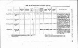
Show resentative of the company has agreed on its behalf to the payment of the damages set out in these schedules. The schedules have not yet been submitted to the department for approv.al. Lake Creek and Coeur dJAlene Railroad.-A map of dehite loca-tion for 8.26 miles across the Coeur d'Alene Reservation was ap-proved August 10, 1908. This' is an extension to the line for 2.36 miles which was approved June 14, 1907. Tribal damages in the sum of $754.69 have been assessed and paid. Missour% Rivw Railroad.-Maps showing four station grounds of. 13.77 acres each within the Standing Rock Reservation, N. Dak., were approved October 8, 1908. Tribal damages in the sum of $328.88 and damages to individual Indian allottees in the sum of - $331.86 have been assessed and paid. On the same date there were approved maps of four station grounds of 13.77 acres each within the Fort Berthold Resention, N. Dak. Tribal damages in the sum of $68.90 and damages to individual Indian allottees in the sum of $504.28 have been assessed and paid. Minnesota and Manitoba Railroad.-Maps for 19.88 acres taken for station grounds at Graceton and 20 acres for station grounds at ~ooseielt, within the Red Lake Indian Reservation, Minn., were approved on February 3, 1909. Montana, Wyoming and Southern Railroad-On April 17, 1909, the department approved a map of dehite location for 10.66 miles of right of way through the Northern Cheyenne Reservation, Mont. On May 12, 1909, a map for 13.52 acres selected by the company for station grounds within the same reservation was approved. Ap-praisers have been designated to assess the damages. Nevada-California-Oregon Railroad.-On April 16, 1909, the de-partment approved a map of amended dehite location for this ' line from Madeline to Likely, across certain Indian allotments in Modoc County, Cal. The amended location is for a distance of 5.4 miles and crosses the allotments of eight individuals. Damages caused thereby are in process of adjustment. Northern Paeif;~R ailway.-On July 31, 1908, there ww approved in favor of this company a right of way for a distance of 9.994 miles across the Quinaielt Reservation. On February 16, 1909, the com-pany fled a relinquishment of this selection, and there are pending before the office maps of dehite location'in the name of the Penin-sula Oriental Railroad Company. This company has also filed maps for three station grounds, each of 20.6 acres, on the Yakima Reservation. These station grounds are located at Satass, Toppenish, and Simcoe. These stations have long been in existence and are claimed by the Northern Pacific Railroad under the provisions of the act of July 2, 1864 (13 Stat. L., 365). |


