| Title |
Draper Selective RLS--2003 (11400 South EIS Project) |
| Grouping |
481 |
| State |
Utah |
| County |
Salt Lake County |
| City |
Riverton, Draper, Sandy City, South Jordan |
| Scanning Institution |
Utah Correctional Institute |
| Collection |
Utah Historic Buildings Reports Collection |
| Date |
2003 |
| UTSHPO Collection |
Salt Lake County RLS |
| Spatial Coverage |
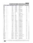
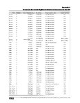
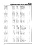
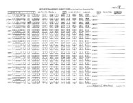
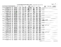
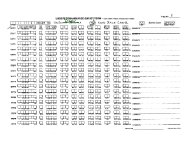
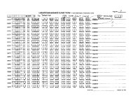
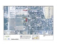
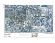
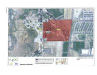
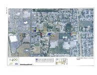
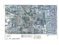
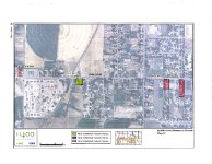
APE is bounded on the west by the Bangerter Hwy (Utah Hwy 154), on the north by 10400 S 10600 S (South Jordan Parkway), on the east by 700 E, and on the south by 12600 S, an area approximately 18 sq mi. The structures are located throughout the APE but are concentrated on seven streets: 700 W, 1300 W, 3600 W, 11000 S, 11400 S, 11800 S, and Kimballs Way. Fifteen of the structures are located within Riverton, eight are in Draper, five are in Sandy City, and six are in South Jordan. |
| Rights Management |
Digital Image © 2025 Utah State Historic Preservation Office. All Rights Reserved. |
| Publisher |
Utah State Historic Preservation Office |
| Genre |
Historic Buildings Reports |
| Type |
Text |
| Format |
application/pdf |
| Date Digital |
2025-06-11 |
| Language |
eng |
| ARK |
ark:/87278/s6z9cy0h |
| Setname |
dha_uhbrep |
| ID |
2727705 |
| Reference URL |
https://collections.lib.utah.edu/ark:/87278/s6z9cy0h |