Contents | 16 of 17
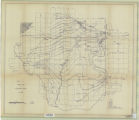
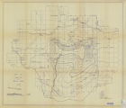
Plate16 Isopach map of Rim Rock Sandstone
| Title | Stratigraphic analysis of the Mesaverde Group, Uinta Basin, Utah |
| Publication Type | thesis |
| School or College | College of Mines & Earth Sciences |
| Department | Geology & Geophysics |
| Author | Gross, Larry T. |
| Date | 1961-05 |
| Description | In the Uinta Basin the Mesaverde Group of Late Cretaceous age is gradational with and often intertongues with the underlying Mancos Shale, The Mesaverde Group"" consists of three principal facies based on their environment of deposition. The three facies are: a littoral or nearshore sandstone facies, a lagoonal or coal- bearing facies, and an inland or non-coal bearing facies. No new names are proposed for the units within the Mesaverde Group, but usage of Book Cliffs terminology for the group through out the Uinta Basin when possible is recommended. In the Uinta Basin the Mesaverde Group consists of three formations which, in ascending order, are: the Star Point Sandstone, the Blackhawk Formation, and the Price River Formation. The Star Point Sandstone is a massive sandstone unit in the Wasatch Plateau, but in the Book Cliffs it consists of two sandstone tongues; the Panther and the Storrs. The two sandstone tongues are separated by westward extending Mancos Shale tongues. The Blackhawk Formation is a sequence of cyclic sandstones, siltstones, shales, and coals. The Blackhawk tongues into the Mancos Shale in the eastern Book Cliffs, but it is present in the subsurface in most of the Uinta Basin. The Asphalt Ridge Sandstone of the Vernal, Utah area, is considered a Blackhawk equivalent. The lower part of the Price River Formation can be differentiated into three sandstone members; the Castlegate, Sego, and Rim Rock. The Castlegate Spndstone Member (or Castlegate Sandstone) of the Price River Formation is the most consistent unit of the formation. The Sego Sandstone (or Sego Sandstone Member) of the Price River Formation is present east of Green River, Utah, and is only recognized in the Uinta Basin where the Buck Tongue of the Mancos Shale is present. The Rim Rock Sandstone is present in the Vernal, Utah area, and is probably equal to the Castlegate and Sego combined. The Price River above the lower sandstone members can be differentiated into two major facies east of Green River, Utah. The two facies, in ascending order, are: the Neslen Facies, a coal-bearing facies, and the Farrer Facies, a non-coal-bearing facies. The upper Price River Formation west of Green River, Utah, and in the Vernal, Utah area, cannot feasibly be subdividedinto two facies. The Masaverde Group is apparently conformably overlain by the Cretaceous (?) North Horn or Tuscher formations in the Book Cliffs, but in the northern part of the basin the group is disconformably overlain by Cretaceous (?), Eocene, and younger strata. The source for the Mssaverde Group was predominantly to the west, but sand-shale ratio maps indicate a possible northwestern and northern source for part of the Castlegate and Sego sandstones of the Price River Formation. |
| Type | Text; Image |
| Publisher | University of Utah |
| Subject | Geology; Stratigraphic; Cretaceous; Uinta Basin (Utah and Colo.) |
| Dissertation Institution | University of Utah |
| Dissertation Name | Master of Science |
| Language | eng |
| Relation is Version of | Digital reproduction of Stratigraphic analysis of the Mesaverde Group, Uinta Basin, Utah, J. Willard Marriott Library Special Collections, QE3.5 1961 .G76 |
| Rights Management | In the public domain use of this file is allowed in accordance with the Creative Commons Attribution-Noncommercial-No Derivative Works 3.0 United States License, http://creativecommons.org/licenses/by-nc-nd/3.0/us |
| Format | application/pdf |
| Format Medium | application/pdf; image/jpeg |
| Identifier | us-etd3,15592 |
| Source | Original: University of Utah J. Willard Marriott Library Special Collections |
| Conversion Specifications | Original scanned on Epson GT-30000/Epson Expression 836XL as 400 dpi to pdf using ABBYY FineReader 9.0 Professional Edition. |
| ARK | ark:/87278/s64x5pkv |
| Setname | ir_etd |
| ID | 195065 |
| Reference URL | https://collections.lib.utah.edu/ark:/87278/s64x5pkv |
Page Metadata
| Title | Plate16 Isopach map of Rim Rock Sandstone |
| Description | In the Uinta Basin the Mesaverde Group of Late Cretaceous age is gradational with and often intertongues with the underlying Mancos Shale, The Mesaverde Group"" consists of three principal facies based on their environment of deposition. The three facies are: a littoral or nearshore sandstone facies, a lagoonal or coal-bearing facies, and an inland or non-coal bearing facies. No new names are proposed for the units within the Mesaverde Group, but usage of Book Cliffs terminology for the group through out the Uinta Basin when possible is recommended. In the Uinta Basin the Mesaverde Group consists of three formations which, in ascending order, are: the Star Point Sandstone, the Blackhawk Formation, and the Price River Formation. The Star Point Sandstone is a massive sandstone unit in the Wasatch Plateau, but in the Book Cliffs it consists of two sandstone tongues; the Panther and the Storrs. The two sandstone tongues are separated by westward extending Mancos Shale tongues. The Blackhawk Formation is a sequence of cyclic sandstones, siltstones, shales, and coals. The Blackhawk tongues into the Mancos Shale in the eastern Book Cliffs, but it is present in the subsurface in most of the Uinta Basin. The Asphalt Ridge Sandstone of the Vernal, Utah area, is considered a Blackhawk equivalent. The lower part of the Price River Formation can be differentiated into three sandstone members; the Castlegate, Sego, and Rim Rock. The Castlegate Spndstone Member (or Castlegate Sandstone) of the Price River Formation is the most consistent unit of the formation. The Sego Sandstone (or Sego Sandstone Member) of the Price River Formation is present east of Green River, Utah, and is only recognized in the Uinta Basin where the Buck Tongue of the Mancos Shale is present. The Rim Rock Sandstone is present in the Vernal, Utah area, and is probably equal to the Castlegate and Sego combined. The Price River above the lower sandstone members can be differentiated into two major facies east of Green River, Utah. The two facies, in ascending order, are: the Neslen Facies, a coal-bearing facies, and the Farrer Facies, a non-coal-bearing facies. The upper Price River Formation west of Green River, Utah, and in the Vernal, Utah area, cannot feasibly be subdivided into two facies. The Mesaverde Group is apparently conformably overlain by the Cretaceous (?) North Horn or Tuscher formations in the Book Cliffs, but in the northern part of the basin the group is disconformably overlain by Cretaceous (?), Eocene, and younger strata. The source for the Mssaverde Group was predominantly to the west, but sand-shale ratio maps indicate a possible northwestern and northern source for part of the Castlegate and Sego sandstones of the Price River Formation. |
| Type | Image |
| Relation is Version of | Digital reproduction of Plate16 Isopach map of Rim Rock Sandstone, J. Willard Marriott Library Special Collections, QE3.5 1961 .G76 |
| Format | application/pdf |
| Format Medium | image/jpeg (visual file) |
| Format Extent | 111,435 bytes |
| Identifier | us-etd3,15607 |
| Conversion Specifications | Original Scanned on Colortrac Smartlf GxT42 and saved as 300dpi tiff. Final display image generated by CONTENTdm. |
| Setname | ir_etd |
| ID | 195063 |
| Reference URL | https://collections.lib.utah.edu/ark:/87278/s64x5pkv/195063 |


