| Title |
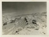
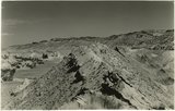
Eroded flank of the East Kaibab monocline at the junction of Paria River and Cottonwood Creek (left center). The sequence is Navajo (left), upper Jurassic (largely eroded), Dakota, Tropic, and Straight Cliffs. Kane County, UT, 1944 |
| Photo Number |
P0013n12_040_2887 |
| Description |
Photo shows the eroded flank of the East Kaibab monocline at the junction of Paria River and Cottonwood Creek (left center) in Kane County, Utah, in 1944. The sequence is Navajo (left), upper Jurassic (largely eroded), Dakota, Tropic, and Straight Cliffs. Photo used in Gregory's article, "Geology and Geography of Central Kane County, Utah," published in the Bulletin of the Geological Society of America, vol. 59. Photograph from Herbert E. Gregory Book 12: Colorado Plateau, Province, 1942-1944 |
| Creator |
Gregory, Herbert E. (Herbert Ernest), 1869-1952 |
| Date |
1944 |
| Textual Date |
1944 |
| Keywords |
Photographs; Black-and-white photographs |
| Subject |
Geology--Utah--Kane County--Photographs; Paria River Valley (Utah and Ariz.)--Photographs |
| Spatial Coverage |
Kane County (Utah); Paria River Valley (Utah and Ariz.) |
| Additional Information |
Photograph from Herbert E. Gregory Box 16 Folder 10. Another copy located in Herbert E. Gregory Book 12: Colorado Plateau, Province, 1942-1944 - Scrapbook identifier ark:/87278/s60904br |
| Collection Number and Name |
P0013 Herbert E. Gregory Photograph Collection |
| Collection Name |
Herbert E. Gregory |
| Rights |
 |
| Type |
Image |
| Finding Aid |
http://archiveswest.orbiscascade.org/ark:/80444/xv18865/ |
| Digitization Specifications |
Digital images produced on Epson Expression 10000 XL scanner, 24-bit color at 800 ppi and cropped using Adobe Photoshop CC 2017 (Macintosh). Archival files are uncompressed TIFF. |
| ARK |
ark:/87278/s6bk5bpg |
| Setname |
uum_map |
| ID |
1305012 |
| Reference URL |
https://collections.lib.utah.edu/ark:/87278/s6bk5bpg |