| OCR Text |
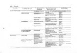
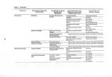
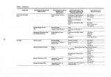
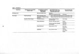
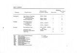
Show Table 3. Continued. Category Classification Primary Data Collection Agency Adequacy Near Shore Watershed Lake Geological Lake Bottom Topology GSL Predecessors ( Lake Bonneville) Bottom Sediments USGS, UGMS USGS, UGMS USGS, UGMS N A N Wildlife Marshland Users & Inhabitants Island Users & Inhabitants UDWR, USBSFW UDWR, USBSFW A A Societal Recreational Uses Industrial Uses Population Information Land Use NPS, UDWR, USPRD, BLM A UGMS, USBM A USDES NOAA - National Oceanic and Atmospheric Administration USGS - U. S. Geological Survey SCS • Soil Conservation Service UGMS - Utah Geological and Mineralogical Survey UDH • Utah Division of Health USWPCB - Utah Stale Water Pollution Control Board USPHS - U. S. Public Health Service UDWR - Utah Division of Wildlife Resources USBSFW - U. S. Bureau of Sport Fisheries and Wildlife NPS - National Park Service USPRD - Utah State Parks and Recreation Division BLM • Bureau of Lund Management USBM - U. S. Bureau of Mines USDES - Utah State Department of Employment Security A = Adequate P = Partly Adequate N = Not Adequate |


