| OCR Text |
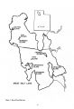
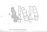
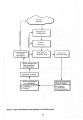
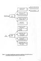
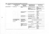
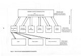
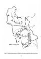
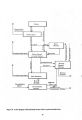
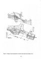
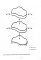
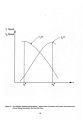
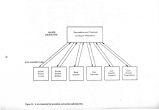
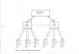
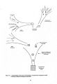
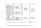
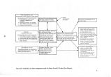
Show Great Salt Lake is fed by three main surface inflows, namely, the Bear, Weber, and Jordan Rivers. Water development within the Great Salt Lake drainage has centered around projects within these river basins. The Bear River has been partially developed for power and irrigation purposes with several storage reservoirs within the basin. The Weber River basin has undergone extensive development under the Weber River Project of the U. S. Bureau of Reclamation. Inflow to Great Salt Lake from the Jordan River has been affected by the development of water supply for the Salt . Lake City area and through the development of the streams which feed Utah Lake. Under the proposed Central Utah Project the flow of the Jordan River would undergo further alteration. The development of reservoirs in the vicinity of Great Salt Lake appears to be essential for developing large quantities of fresh water now " wasting" into Great Salt Lake. Two alternatives are most apparent: creation of off stream reservoirs such as ( 1) Willard Bay reservoir, and ( 2) connecting the east lake islands and the mainland with a system of dikes to create a . fresh water body within the present Great Salt Lake boundaries. Further development of the present inflow to Great Salt Lake, whether upstream or within the vicinity of Great Salt Lake, will have to be a compromise between developing new fresh water supplies and maintaining the level of Great Salt Lake to serve other interests, such as recreation, tourism, wildlife, and mineral extraction. Before the railroad developed as an efficient means of transportation, shipping on Great Salt Lake was an important means of transportation. Ore, salt, livestock, and passengers were the major cargoes. The largest vessel to use the lake was the steam powered " City of Corinne" constructed in Corinne, Utah. It was launched in 1871 to carry ore mined in the Oquirrh Mountains to the smelter at Corinne. The Southern Pacific Railroad Company eliminated Great Salt Lake as a barrier to rail transportation with the completion of the Lucin Cutoff across the waters of the lake in 1904. The cutoff was completed with the construction of a wooden trestle with short sections of fill at each end across the main body of the lake from the east shore to Promontory Point. During the 1950' s, the main section of trestle was replaced with a rock and gravel causeway. As a result, the lake essentially has been divided into two separate portions or arms. The major effect of the causeway has been the disruption of the brine concentrations in the north and south arms of the lake and the resulting effect on the mineral extraction industry. Additionally, travel on the lake by watercraft has been restricted. The effects the railroad causeway has had on alternative uses of the resources of Great Salt Lake further illustrate the need for comprehensive coordinated management of the total resources of the Great Salt Lake system. Past Development and Use Strategies The main effort at a coordinated development of Great Salt Lake has centered around the development of fresh water storage reservoirs within the present boundary of Great Salt Lake. During the 1930' s, two different schemes for diking the lake were proposed. The " large project" consisted of a diking system extending westerly from the mainland to the southern , end of Antelope Island, from the north end of Antelope Island to the southern end of Fremont Island, land from the north end of Fremont Island to Promontory Point. The reservoir created by this inter- island diking system would capture the flow of the Bear, Weber, and Jordan Rivers. Under the " small project," dikes would be constructed to connect the north and south ends of Antelope Island to the mainland. Water for this reservoir would be supplied by the Jordan River and a diversion canal from the Weber River. Even though feasibility studies were undertaken, interest in these projects was lost. In 1955, the Utah Legislature authorized the Utah State Road Commission to initiate a study on the advisability and feasibility of creating a fresh water reservoir through the construction of an inter- island diking network. The findings were summarized in a 1958 report by the Advisory Committee to Utah State Road Committee entitled " Great Salt Lake Diking Study." The report recommended: 1. The State of Utah acquire all or part of Antelope Island for development as a state park. 2. The construction of dikes to form the i large project be undertaken as early as possible. 3. Roads be constructed on the dikes in conjunction with connecting roads to form a scenic ' loop' which would include Salt Lake City, Antelope Island, Fremont Island, and Promontory Point 4. A comprehensive survey be made to determine the demand for water of the quality that would be produced in the fresh water lake. The major effort to coordinate the development of Great Salt Lake was undertaken when the Utah State Legislature created the Great Salt Lake Authority in 1963. The Great Salt Lake Authority was given the responsibility to plan, formulate, and execute a program for the development of the mainland, islands, minerals, and water within the Great Salt Lake meander line for industrial, recreational, agricultural, and chemical purposes. The authority was directed 8 |