| OCR Text |
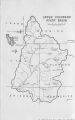
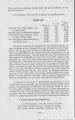
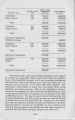
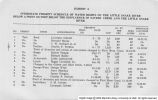
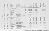
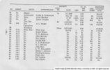
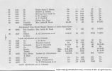
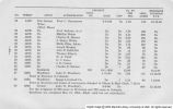
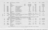
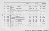
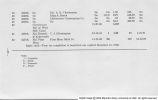
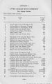
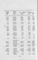
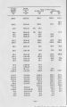
Show Drainage Area Ref. Stream Sq. Miles (1) (2) (3) 98. (B) Sheep Creek Lower Canal 99. Slater Fork near Slater, Colorado 161 100. f Snake River near Montezuma, Colorado 59 101. fSouth Fork White River near Buford, Colorado 102. (C) Spring Creek at LaBoc.a, Colorado, near Colorado-Utah state line 103. Strawberry River at Duchesne, Utah 1,040 104. Taylor River at Almont, Colorado 440 105. Tenmile Creek at Dillon, Colorado 113 106. Tomichi Creek at Gunnison, Colorado 1,020 107. Uinta River near Neola, Utah 181 108. Uncompahgre River near Colona, Colorado 437 109. West Fork Beaver Creek near Lonetree, Wyo. 110. West Fork Smith Fork near Robertson, Wyo. 37 111. White River near Meeker, Colorado 762 112. White River near Watson, Utah 4,020 113. Whiterocks River near Whiterocks, Utah 115 114. Willow Creek near Ouray, Utah 967 115. Yampa River near Maybell, Colorado 3,410 116. Yampa River at Steamboat Springs, Colorado 604 *This is a U. S. G. S. station but is not required at the present time for administration by the Upper Colorado River Commission. **Drainage area not shown in latest U. S. G. S. water supply paper available. fThis station is to be installed or reestablished and operated by the U. S. G. S. for administration purposes by the Upper Colorado River Commission. ffThis station has recently been installed. (A) Lee Ferry one mile down stream from the mouth of the Paria River is the 1922 "Compact Point," and the discharge at this point is taken as the sum of Nos. 25 and 76. -70- |