| OCR Text |
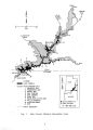
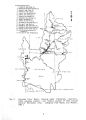
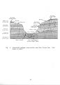
Show LIST OF FIGURES Figure 1. Glen Canyon National Recreation Area 2. Colorado River Basin, showing major tributaries, reservoirs, USGS gauging stations, and relative location of Glen Canyon National Recreation Area . 3. Generalized geologic cross- section near Glen Canyon Dam LIST OF TABLES Table 1. History of the Bureau of Reclamation major ion chemistry and physical limnology monitoring program in Lake Powell ......... 2. Water quality information from long- term USGS monitoring stations on the major inflow tributaries of Lake Powell . 3. Metal content analyses of fish flesh samples taken at USFWS Station 93, Colorado River at Lake Powell, Arizona 4. Proposed shoreline and marina bacterial monitoring for Glen Canyon National Recreation Area .... 5. Recommended monitoring sites for establishing baseline resources data related to potential tar sands development in Glen Canyon National Recreation Area 6. Suggested surface- water- quality monitoring program for streams, springs, and seeps located in the vicinity of tar sands development ....... 7. Suggested ground- water- quality monitoring program for aquifer sites located in the vicinity of tar sands development ......... 8. Proposed bacteria monitoring schedule for heavily- used beaches in Glen Canyon National Recreation Area . 9. Study design for proposed primary and secondary productivity studies for Lake Powell .... v |