| OCR Text |
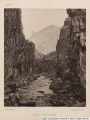
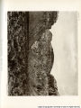
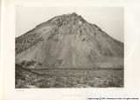
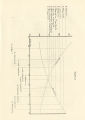
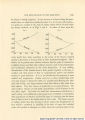
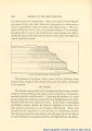
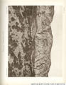
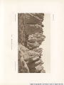
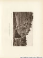
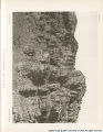
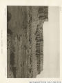
Show 30 GEOLOGY OF THE HIGH PLATEAUS. planes confirmed the belief that the faults really existed. In the middle of the range the obscurity is still greater. Volcanic activity, producing great distortion and destruction of the stratification, has made it impossible to unravel the complications of the displacement. I only know that the upper Jurassic beds appear at the base and again high up in the heart of the range and in a very distorted and more or less metamorphic condition at intermediate places. I have cut the knot, and represented the movement in the stereogram as a simple fault. Near the northern end of the Tushar the fault is shown more clearly, and is there relatively simple, though not without some slight complexities arising from undulation of the strata. The same line of displacements extends beyond the Tushar along the eastern flank of the Pavant, which is the northern continuation of that range. Here it is at first a simple fault, but gradually becomes a monoclinal beyond the town of Richfield by the thrown strata flexing gradually upward until they meet the ends of the beds on the lifted side. Opposite Salina it suddenly changes its trend to the northwest and forms the western wall of Round Valleyâ€"a depression cutting through the Pavant obliquely. The length of this displacement is about 80 miles. The Toroweap* fault cannot be reckoned among the greater faults, though it is so noticeable and conspicuously exhibited that it deserves mention. It crosses the Grand Canon near Mount Trumbull, about 11 miles east of the Hurricane fault, with a throw to the west of about 700-800 feet, but in the course of about 20 miles to the northward it probably runs out. Very little is known concerning it south of the river. It is a fault of the simplest order. The fourth great displacement is the Sevier fault It commences about 35 miles north of the Grand Canon. It makes its first appearance at "Pipe Spring," at the base of the Vermilion Cliffs, and presents a remarkable atti-tude.f Approaching it from the west, the beds are turned down on the * The Toroiveap is a valley opening upon the middle terrace of the Grand Canon from the north side, It was excavated and its stream dried up before the commencement of the cutting of the inner chasm, and its floor, therefore, remains about on a level with the middle terrace. It is a magnificent avenue of approach to a sublime spectacle of the Grand Canon, bringing the observer to the brink of the inner abyss, where he may look vertically downwards more than 3,000 feet and with more than 2,000 feet of wall above him. The name Toroweap signifies "a clayey locality." t There are some indications that it extends a few miles south of Pipe Spring, but it is covered with soil and sand. |