| Title |
Views along Vermilion Cliffs [and] Permian and Triassic rocks at the mouth of Limestone Gulch |
| Photo Number |
P0013n16_12_14 |
| Description |
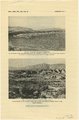
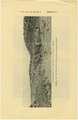
Copy of plates 2 and 3 in Gregory's article, "Geology and Geography of Central Kane County, Utah," published in the Bulletin of the Geological Society of America, vol. 59 (1948), with three photographs showing a view east from Pioneer Gap; a view north from Lower Road Creek across Petrified Forest member and the upper red sandstone member of the Chinle formation to the Vermilion Cliffs, and a photo of the Permian and Triassic rocks at the mouth of Limestone Gulch, with Kaibab limestone and Timpoweap member of Moenkopi formation. |
| Creator |
Gregory, Herbert E. (Herbert Ernest), 1869-1952 |
| Date |
1943; 1944; 1945 |
| Keywords |
Photographs; Black-and-white photographs |
| Subject |
Geology--Utah--Kane County--Photographs |
| Spatial Coverage |
Kane County (Utah) |
| Collection Number and Name |
P0013 Herbert E. Gregory Photograph Collection |
| Collection Name |
Herbert E. Gregory |
| Rights |
 |
| Type |
Image |
| Finding Aid |
http://archiveswest.orbiscascade.org/ark:/80444/xv18865/ |
| Digitization Specifications |
Digital images produced on Epson Expression 10000 XL scanner, 24-bit color at 800 ppi and cropped using Adobe Photoshop CC 2017 (Macintosh). Archival files are uncompressed TIFF. |
| ARK |
ark:/87278/s68s8p98 |
| Setname |
uum_map |
| ID |
1305435 |
| Reference URL |
https://collections.lib.utah.edu/ark:/87278/s68s8p98 |