Over 70,000 photos covering a variety of topics from Marriott Library Special Collections
TO
| Title | Collection Number And Name | Photo Number | ||
|---|---|---|---|---|
| 51 |
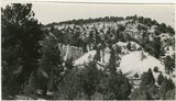 |
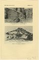
Brian Head formation, branch of Asay Creek; lies beneath basalt flows. Garfield County, UT, 1944 | P0013 Herbert E. Gregory Photograph Collection | P0013n12_072_2935 |
| 52 |
 |
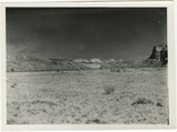
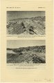
Sevier River formation overlaid by basalt near mouth of Corral Creek on Highway 89, 2 miles east of Panguitch. Garfield County, UT. 1944 | P0013 Herbert E. Gregory Photograph Collection | P0013n12_075_2940A |
| 53 |
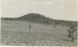 |
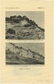
Bowers Knoll; Volcano viewed from northwest. Garfield County, UT. 1944 | P0013 Herbert E. Gregory Photograph Collection | P0013n12_076_2940B |
| 54 |
 |
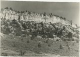
Hillside of eroded rock, Paria Valley, Utah | P0013 Herbert E. Gregory Photograph Collection | P0013n16_12_01 |
| 55 |
 |
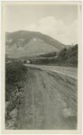
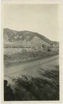
Road and lava field, Rock Creek Valley, Utah | P0013 Herbert E. Gregory Photograph Collection | P0013n16_12_02 |
| 56 |
 |
Rocky cliff near Hillsdale | P0013 Herbert E. Gregory Photograph Collection | P0013n16_12_03 |
| 57 |
 |
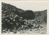
Lava, Black Rock Valley | P0013 Herbert E. Gregory Photograph Collection | P0013n16_12_04 |
| 58 |
 |
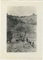
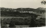
Paria Valley and east flank of East Kaibab monocline | P0013 Herbert E. Gregory Photograph Collection | P0013n16_12_05 |
| 59 |
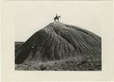 |
Mound of sedimentary material, vicinity of Paria River, Utah | P0013 Herbert E. Gregory Photograph Collection | P0013n16_12_06 |
| 60 |
 |
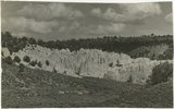
Sandstone outcrops, Paria Canyon, Utah | P0013 Herbert E. Gregory Photograph Collection | P0013n16_12_07 |
| 61 |
 |
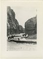
Paria Canyon, Utah | P0013 Herbert E. Gregory Photograph Collection | P0013n16_12_08 |
| 62 |
 |
White rocks on road to Panquitch, Utah | P0013 Herbert E. Gregory Photograph Collection | P0013n16_12_09 |
| 63 |
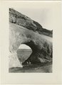 |
East side of Lone Rock on Wah Weap Creek | P0013 Herbert E. Gregory Photograph Collection | P0013n16_12_10 |
| 64 |
 |
Upper Box in Paria Canyon just south of Cannonville | P0013 Herbert E. Gregory Photograph Collection | P0013n16_12_11 |
| 65 |
 |
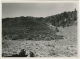
End of lava flow 6 miles long in Black Creek Valley | P0013 Herbert E. Gregory Photograph Collection | P0013n16_12_12 |
| 66 |
 |
White cliffs along highway south of Asay Creek, Brian Head formation | P0013 Herbert E. Gregory Photograph Collection | P0013n16_12_13 |
| 67 |
 |
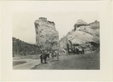
Views along Vermilion Cliffs [and] Permian and Triassic rocks at the mouth of Limestone Gulch | P0013 Herbert E. Gregory Photograph Collection | P0013n16_12_14 |
| 68 |
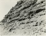
 |
Views of the Moenkopi Formation [and] Triassic rocks | P0013 Herbert E. Gregory Photograph Collection | P0013n16_12_15 |
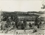
| 69 |
 |
Wingate Sandstone [and] Features of Jurassic and recent formation | P0013 Herbert E. Gregory Photograph Collection | P0013n16_12_16 |
| 70 |
 |
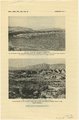
Features of the East Kaibab monocline [and] Structural relations of rocks along Utah-Arizona boundary | P0013 Herbert E. Gregory Photograph Collection | P0013n16_12_17 |
| 71 |
 |
Montana State University, Bozeman Montana [01] | P0029 Joseph Kingsbury Photograph Collection | P0029n01_06_02 |
| 72 |
 |
Montana State University, Bozeman Montana [02] | P0029 Joseph Kingsbury Photograph Collection | P0029n01_06_03 |
| 73 |
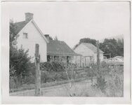 |
Paragonah, Utah, home of Eliza Edwards Hanks [02] | P0029 Joseph Kingsbury Photograph Collection | P0029n01_06_06 |
| 74 |
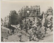 |
Bryce Canyon National Park [01] | P0083 Maud May Babcock photograph collection, 1852-1949 | P0083add1n03_07_766A |
| 75 |
 |
Cedar Breaks, Utah [02] | P0083 Maud May Babcock photograph collection, 1852-1949 | P0083add1n03_07_767A |