| OCR Text |
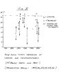
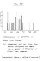
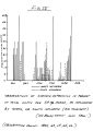
Show 7 climax avalanches are not common. Old snow packs, after 6 to 10 days of mild weather usually can be considered completely stable. These will tend to serve as a future slide surface rather than be involved in any climax activity. This has been observed to be true even with a depth hoar layer at ground level, air pockets in the pack, or internal layers of ice. Wind, sometimes inhibits avalanche danger. Since our strongnorth winds blow after clearing, their warming effect accelerates settlement and metamorphism. They scallop the old snow surface to allow new snow layers to form a bond, and due to their strength and speed carry unconsolidated snow downslope, rather than build up cornices or unstable cushions on canyon walls. Storm winds from the south are usually comparatively gentle. They tend to pack the new snow rather than to build up dangerous unevenness. HAZARD FORECASTING Avalanche hazard forecasting consists primarily of: 1. Tracing, in the local newspaper weather map, clouds or warm fronts, and low and high pressure areas, in relation to north or south influence 2. The observation of storm intensities at localities prior to the frontal passage, such as rainfall figures up the coast in Los Angeles, Santa Barbara, etc. and the consequent clearing at these areas prior to local clearing. 3- Close observation of the temperature curve, if possible, to determine direction of heat exchange. |