| Description |
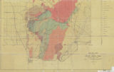
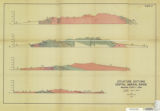
The subject area covers approximately 250 square miles, ""Which includes the central portion of the Mineral Range, an elongate belt of rugged mountains located in the eastern third of Beaver County, Utah. In gross detail, the range is formed of a large granite pluton, which is flanked by Paleozoic and Mesozoic sediments on the south, and lower Paleozoic sediments on the north. Mesozoic sedimentary rocks crop out on the east and west flanks, and a belt of Precambrian metamorphic rocks are exposed along the west side. The area is bounded by Beaver Valley on the east, Milford Valley on the west, Hot Springs Canyon on the north, and by Utah State Highway 21 on the south. Boundary lines have been drawn to include a standard fifteen minute quadrangle except for a small additional area north of Highway 21 on the south. Stratified rocks, exposed within the mapped area, include from the base to the top: 3,000 feet of Precambrian gneiss, schist, and meta- igneous rocks; 3,000 feet of lower Paleozoic limestone and dolomites; 1,000 feet of Mississippian limestones referred to the Topache formation; the Permian Coconino and Kaibab formations aggregating almost 2,000 feet, the Triassic Moenkopi group some 2,000 feet in thickness; the Jurassic Navajo sandstone and Carmel limestone with an aggregate thickness of roughly 2,000 feet, the Cretaceous Claron (?) conglomerate; and Quaternary deposits of Bonneville age which are exposed on the western flanks of the range. Unconformities are recognized above the Precambrian; at the base of the Mississippian, at the base of the Permian and; at the base and at the top of the Cretaceous. Two stages of faulting are recognized in late Cretaceous or early Tertiary time associated with the Laramide orogeny. Igneous rocks include the Mineral Range pluton; the small Lincoln stock and numberous related bodies; andesite, aplite, and pegmatite dikes; large granite sills; a northern rhyolitic volcanic series; and a southern volcanic series composed of basal andesites, grading into quartz latites, and capped by basalt. Emplacement of the Mineral Range pluton is believed to have occurred in late Cretaceous or early Tertiary time. The body is remarkably homogenous, throughout its central part, being composed of coarse grained granite which is characterized by a marked deficiency in the normal ferro-magnesian components and calcium. The western margin of the body, however, has a gradational contact with the Precambrian rocks which forms a linear belt of ferro-magnesian rich rock. The southern volcanics post-date folding and initial fault movements, and pre-date the second stage of faulting. The northern, late Tertiary volcanics, post-date uplift of the range and pre-date the Pleistocene Lake Bonneville. At the present writing, mining activity is at a near standstill throughout the range. In past years, however, the area supported four mining districts: the Bradshaw, Lincoln, Granite, and North Granite districts, the last two of which are treated as a unit in the present report. Deposits mined were complex ores of gold, silver, lead, and copper, with some tungsten being mined during the late war years. The Bradshaw district, largest producing district of the range, has a total production record of 11,000 tons valued at approximately $305,000.00, two-thirds of this gross being recovered in gold and silver values. Production of the Lincoln district is over 7,000 tons valued at $161,000.00, more than half of which was in lead and silver values. The Granite and North Granite have produced 948 tons of base and precious metal ores valued at $50,000.00, again largely in gold and silver. Tungsten production, begun during the war years, was largely from two mines in the Granite district. Total tungsten production of all districts was 1,182 tons, valued at $20,000.00. Beryllium ore has recently been discovered at the Miller Mine, and development work is currently in progress. Other deposits of economic importance that have been exploited include pumice, perlite, and some building and decorational stone. Large reserves of pumice and perlite are available in the northern volcanic area, but market conditions have retarded development to a large degree. |


