Home
Browse
Ask Us
Chat
Harmful Language Statement
Log in
Advanced Search
Year
1930
1931
1932
1933
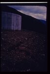
1934
1935
1936
1937
1938
1939
1940
1941
1942
1943
1944
1945
1946
1947
1948
1949
1950
1951
1952
1953
1954
1955
1956
1957
1958
1959
1960
1961
1962
1963
1964
1965
1966
1967
1968
1969
1970
1971
1972
1973
1974
1975
1976
1977
1978
1979
1980
1981
1982
1983
1984
1985
1986
1987
1988
1989
1990
1991
1992
1993
1994
1995
1996
1997
1998
1999
2000
2001
2002
2003
2004
TO
1930
1931
1932
1933
1934
1935
1936
1937
1938
1939
1940
1941
1942
1943
1944
1945
1946
1947
1948
1949
1950
1951
1952
1953
1954
1955
1956
1957
1958
1959
1960
1961
1962
1963
1964
1965
1966
1967
1968
1969
1970
1971
1972
1973
1974
1975
1976
1977
1978
1979
1980
1981
1982
1983
1984
1985
1986
1987
1988
1989
1990
1991
1992
1993
1994
1995
1996
1997
1998
1999
2000
2001
2002
2003
2004
Type
Image
100
Text
1
Format
image/jpeg
100
application/pdf
1
Collection
Photo Archives
100
Theses & Dissertations
1
1
-
25
of
101
<
1
2
3
4
5
>
Gallery view
Number of results to display per page
10
25
50
100
200
Sort by Relevance
Sort by Title A-Z
Sort by Title Z-A
Sort by Date Ascending
Sort by Date Descending
Sort by Last Modified Ascending
Sort by Last Modified Descending
Title
Date
Type
Setname
1
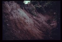
Closeup view of the fault shown in last slide (p1274n093).
Image
uum_map
2
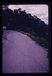
Crack down the highway centerline, showing displacement. U.S. 6 near Colton.
Image
uum_map
3
Failure of front yard before completion of home construction in mountain subdivision.
Image
uum_map
4
Failure of ground bordering on a covered distribution reservoir. Hammer provides scale on displacement scarp.
Image
uum_map
5
Front end view of the slide (p1274n030).
Image
uum_map
6
In the same house; the ceiling is clearly distressed.
Image
uum_map
7
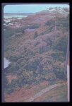
Landslide scarp behind house along mountain front in Weber County.
Image
uum_map
8
Landslide scarplet "getting closer to home" in mountain subdivision.
Image
uum_map
9
Leakage through the undisturbed abutment of an earthfill dam, measured in a wooden weir.
Image
uum_map
10
Ogden Standard Examiner newspaper photograph of mudslide encroaching into dining room.
Image
uum_map
11
Rock-debris flow from source onto road in foreground.
Image
uum_map
12
These twin tanks deverge from bottom to top. Differential settling of their foundations caused this.
Image
uum_map
13
Weber Basin Job Corpsmen digging out mudslide debris from hillside house.
Image
uum_map
14
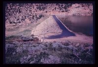
A reservoir showing the earth-fill dam and a landslide block separated from the abutment in the foreground. Opposite abutment is an ancient landslide.
Image
uum_map
15
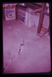
Characteristic arcuate crack pattern in basement of house. Both vertical and lateral displacement is apparent.
Image
uum_map
16
Closer view of head and foot of Park City landslide. Note tilt blocks at head of slide.
Image
uum_map
17
Closer view of slide cracks in high fill in Salt Lake City subdivision. Note housing density downslope.
Image
uum_map
18
Crack in soil alongside reservoir, showing subsidence. Reservoir was the only water storage facility serving several thousand people.
Image
uum_map
19
Erosion of fill placed from home construction. Deposition of material in foreground gives braided stream appearance.
Image
uum_map
20
Excavation and trench cave-ins occur all too frequently along Utah's Wasatch Front. Each year sees its fatalities from this cause.
Image
uum_map
21
Fault trace revealed in the foundation excavation for the building depicted in the preceding photograph (p1274n092).
Image
uum_map
22
Foothill terrain at base of Wasatch Mountains experienced failure illustrated above.
Image
uum_map
23
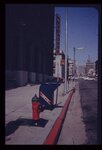
Ground subsidence leaves this fireplug supported above the sidewalk in downtown Salt Lake City.
Image
uum_map
24
Incipient landslide failure on subdivision road. Note characteristic arcuate configuration of ground surface, also patching along crack.
Image
uum_map
25
Landslide of bedrock onto highway; a frequent problem for highway maintenance, sometimes necessitating blasting of large bedrock blocks.
Image
uum_map
1
-
25
of
101
<
1
2
3
4
5
>