Home
Browse
Ask Us
Chat
Harmful Language Statement
Log in
Advanced Search
Year
1807
1808
1809
1810
1811
1812
1813
1814
1815
1816
1817
1818
1819
1820
1821
1822
1823
1824
1825
1826
1827
1828
1829
1830
1831
1832
1833
1834
1835
1836
1837
1838
1839
1840
1841
1842
1843
1844
1845
1846
1847
1848
1849
1850
1851
1852
1853
1854
1855
1856
1857
1858
1859
1860
1861
1862
1863
1864
1865
1866
1867
1868
1869
1870
1871
1872
1873
1874
1875
1876
1877
1878
1879
1880
1881
1882
1883
1884
1885
1886
1887
1888
1889
1890
1891
1892
1893
1894
1895
1896
1897
1898
1899
1900
1901
1902
1903
1904
1905
1906
1907
1908
1909
1910
1911
1912
1913
1914
1915
1916
1917
1918
1919
1920
1921
1922
1923
1924
1925
1926
1927
1928
1929
1930
1931
1932
1933
1934
1935
1936
1937
1938
1939
1940
1941
1942
1943
1944
1945
1946
1947
1948
1949
1950
1951
1952
1953
1954
1955
1956
1957
1958
1959
1960
1961
1962
1963
1964
1965
1966
1967
1968
1969
1970
1971
1972
1973
1974
1975
1976
1977
1978
1979
1980
1981
1982
1983
1984
1985
1986
1987
1988
1989
1990
1991
1992
1993
1994
1995
1996
1997
1998
1999
2000
2001
2002
2003
2004
2005
2006
2007
2008
2009
2010
2011
2012
2013
2014
2015
2016
2017
2018
2019
2020
2021
2022
2023
2024
TO
1807
1808
1809
1810
1811
1812
1813
1814
1815
1816
1817
1818
1819
1820
1821
1822
1823
1824
1825
1826
1827
1828
1829
1830
1831
1832
1833
1834
1835
1836
1837
1838
1839
1840
1841
1842
1843
1844
1845
1846
1847
1848
1849
1850
1851
1852
1853
1854
1855
1856
1857
1858
1859
1860
1861
1862
1863
1864
1865
1866
1867
1868
1869
1870
1871
1872
1873
1874
1875
1876
1877
1878
1879
1880
1881
1882
1883
1884
1885
1886
1887
1888
1889
1890
1891
1892
1893
1894
1895
1896
1897
1898
1899
1900
1901
1902
1903
1904
1905
1906
1907
1908
1909
1910
1911
1912
1913
1914
1915
1916
1917
1918
1919
1920
1921
1922
1923
1924
1925
1926
1927
1928
1929
1930
1931
1932
1933
1934
1935
1936
1937
1938
1939
1940
1941
1942
1943
1944
1945
1946
1947
1948
1949
1950
1951
1952
1953
1954
1955
1956
1957
1958
1959
1960
1961
1962
1963
1964
1965
1966
1967
1968
1969
1970
1971
1972
1973
1974
1975
1976
1977
1978
1979
1980
1981
1982
1983
1984
1985
1986
1987
1988
1989
1990
1991
1992
1993
1994
1995
1996
1997
1998
1999
2000
2001
2002
2003
2004
2005
2006
2007
2008
2009
2010
2011
2012
2013
2014
2015
2016
2017
2018
2019
2020
2021
2022
2023
2024
Type
Text
918
Image/StillImage
94
Image
7
Sound
1
Format
application/pdf
1,259
image/jpeg
69
application/zip
3
application/xml
2
Collection
Alan K Engen Papers
3
American West Center Research Projects
8
Athletics
11
Civilian Conservation Corps Newslette...
1
College of Law Publications
4
College of Nursing
1
Continuum
19
Cycling Utah
4
Department of City and Metropolitan P...
13
Electronic University Archive
30
Elias Hicks Blackburn Papers, 1848-1908
1
Encoded Archival Description (EAD) Fi...
2
Everett L. Cooley Oral History Project
10
Field Notes
6
Frederick William Reynolds Lectures
1
Historic and Prehistoric Publications
164
Honors Theses Closed Archive
2
Honors Theses Open Access
4
Jacob Myers Sr. Papers, 1801-2009
1
Juanita Brooks Papers
14
League of Women Voters of Utah
1
Manuscripts
4
Marriner S. Eccles Papers
2
Marriott Library Digital Stacks
3
Mormon Settlement in Arizona
6
NOVEL - Walsh and Hoyt Textbook
2
Network Magazine Records
3
Peoples of Utah Revisited
1
Rare Books Collection
9
Sanborn Fire Insurance Maps
3
Tanner Trust Books
1
Theses & Dissertations
38
Topaz Museum
1
Topaz Oral Histories
1
UAIDA Main Collection
221
UScholar Works
7
Uintah County Regional History Center...
1
Utah Architects and Builders
1
Utah City Directories Collection
1
Utah Historic Building Records
695
Utah Historic Building Reports
2
Utah Museum of Fine Arts - Albert Tis...
1
Utah National Register Nomination Forms
2
Utah Pharmacy Digest
2
Western Waters Documents
2
Western Waters NEH
23
Westminster University Institutional ...
1
William Harroun Behle Papers
1
More
1
-
25
of
1,334
<
1
2
3
4
5
6
7
8
9
10
>
Gallery view
Number of results to display per page
10
25
50
100
200
Sort by Relevance
Sort by Title A-Z
Sort by Title Z-A
Sort by Date Ascending
Sort by Date Descending
Sort by Last Modified Ascending
Sort by Last Modified Descending
Title
Date
Type
Setname
1
Maps
uaida_main
2
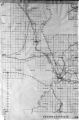
Changes of Ute Territory 1868-1972
Text
uaida_main
3
Maps and Illustrations
uaida_main
4
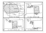
Proposed Southern Ute Reservation Reservation 1879, 1889
Image/StillImage
uaida_main
5
Maps and Illustrations
uaida_main
6
Report of a reconnaissance in the Ute country made in the year 1873, by Lieut. E. H. Ruffner, corps of engineers
1873
Image/StillImage
uaida_main
7
Map of Navajo, Ute, and Jicarilla Apache Indian Reserves
Image/StillImage
uaida_main
8
Map of Southern Colorado and the Ute Mountain Ute Reservation
Image/StillImage
uaida_main
9
The Unisted States Record of Site-Specific Information Regarding The Uintah-Ouray Reservation: Findings of a Survey of National Archives, Smithsonian, and Library of Congress Collections - Page 24
uaida_main
10
The Unisted States Record of Site-Specific Information Regarding The Uintah-Ouray Reservation: Findings of a Survey of National Archives, Smithsonian, and Library of Congress Collections - Page 24
uaida_main
11
Contents
uaida_main
12
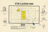
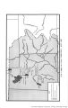
Ute Lands, 1868
Image/StillImage
uaida_main
13
Map of United States Control of Ute Lands
uaida_main
14
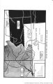
Land Added to Confederated Ute Indian Reservation 1875-76
Text
uaida_main
15
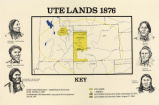
Map titled "Ute Lands, 1876"
Image/StillImage
uaida_main
16
Page 3
uaida_main
17
Map of the Lands of the Ute People
uaida_main
18
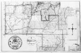
Map of Uncompahgre Ute reservation, Includes parcel divisions
Image/StillImage
uaida_main
19
Map of Ute Lands in Utah Territory, 1847-1861
uaida_main
20
Ute-White Relations in Utah 1847-1850
Image/StillImage
uaida_main
21
Map of the Four Corners Region and the Reservation of the Ute Mountain Ute Tribe
Image/StillImage
uaida_main
22
Map titled, "Northern Ute Lands, 1905"
Image/StillImage
uaida_main
23
Bingham Canyon, 1913: Sheet 02
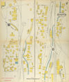
1913
Image
uum_sfim
24
Map of Ute Land Cessions in Colorado Territory, 1863-68
uaida_main
25
Page 4
uaida_main
1
-
25
of
1,334
<
1
2
3
4
5
6
7
8
9
10
>