Home
Browse
Ask Us
Chat
Harmful Language Statement
Log in
Advanced Search
Year
1872
1873
1874
1875
1876
1877
1878
1879
1880
1881
1882
1883
1884
1885
1886
1887
1888
1889
1890
1891
1892
1893
1894
1895
1896
1897
1898
1899
1900
1901
1902
1903
1904
1905
1906
1907
1908
1909
1910
1911
1912
1913
1914
1915
1916
1917
1918
1919
1920
1921
1922
1923
1924
1925
1926
1927
1928
1929
1930
1931
1932
1933
1934
1935
1936
1937
1938
1939
1940
1941
1942
1943
1944
1945
1946
1947
1948
1949
1950
1951
1952
1953
1954
1955
1956
1957
1958
1959
1960
1961
1962
1963
1964
1965
1966
1967
1968
1969
1970
1971
1972
1973
1974
1975
1976
1977
1978
1979
1980
1981
1982
1983
1984
1985
1986
1987
1988
1989
1990
1991
1992
1993
TO
1872
1873
1874
1875
1876
1877
1878
1879
1880
1881
1882
1883
1884
1885
1886
1887
1888
1889
1890
1891
1892
1893
1894
1895
1896
1897
1898
1899
1900
1901
1902
1903
1904
1905
1906
1907
1908
1909
1910
1911
1912
1913
1914
1915
1916
1917
1918
1919
1920
1921
1922
1923
1924
1925
1926
1927
1928
1929
1930
1931
1932
1933
1934
1935
1936
1937
1938
1939
1940
1941
1942
1943
1944
1945
1946
1947
1948
1949
1950
1951
1952
1953
1954
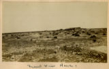
1955
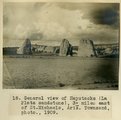
1956
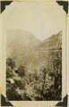
1957
1958
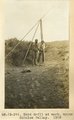
1959
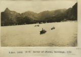
1960
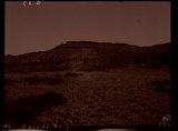
1961
1962
1963
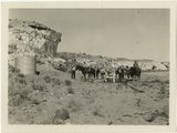
1964
1965
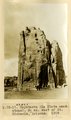
1966
1967
1968
1969
1970
1971
1972
1973
1974
1975
1976
1977
1978
1979
1980
1981
1982
1983
1984
1985
1986
1987
1988
1989
1990
1991
1992
1993
Type
Image
3,521
Image/StillImage
143
Format
image/jpeg
3,594
application/pdf
70
Collection
Photo Archives
3,521
UAIDA Main Collection
143
201
-
225
of
3,664
<
4
5
6
7
8
9
10
11
12
13
>
Gallery view
Number of results to display per page
10
25
50
100
200
Sort by Relevance
Sort by Title A-Z
Sort by Title Z-A
Sort by Date Ascending
Sort by Date Descending
Sort by Last Modified Ascending
Sort by Last Modified Descending
Title
Date
Type
Setname
201
Congar Mt. fault, 1936.
1936
Image
uum_map
202
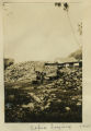
Copra drying
1915
Image
uum_map
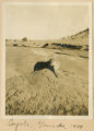
203
Coyote, Ganado 1909
1909
Image
uum_map
204
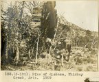
Dike of diabase, Whiskey Creek, Ariz. (negative for photo G-102)
1909
Image
uum_map
205
Dike of diabase, Whiskey Creek, Ariz., 1909 (photo G-102)
1909
Image
uum_map
206
Elkheart Cliffs, 1936.
1936
Image
uum_map
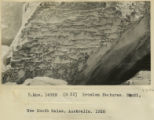
207
Erosion features, Bondi
1916
Image
uum_map
208
First Mesa Wash, Walpi (Negative for photo G-94)
1909
Image
uum_map
209
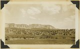
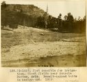
Flat possible for irrigation. Wheat fields near Sonsola Buttes, Ariz. Basalt-capped butte in background, 1909 (photo G-103)
1909
Image
uum_map
210
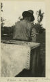
Flies in the desert
1916
Image
uum_map
211
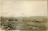
Fort Defiance, Ariz., looking northeast across upturned edges of Dolores and La Plata. Mesa in distance is Mesa Verde, 1908 (Schwemberger photo)
1909
Image
uum_map
212
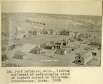
Fort Defiance, Ariz., looking northwest at east-dipping slope of hogback capped by Shinarump, 1908 (Schwemberger photo)
1908
Image
uum_map
213
Ganado, Ariz. (Negative for photo G-37)
1909
Image
uum_map
214
General view near Many Waters Lakes, 16± mi., northeast of Leupp, Arizona (photo G-87)
1909
Image
uum_map
215
General view of Haystacks (La Plata sandstone), 3+ miles east of St. Michaels, Ariz., 1909 (Townsend photo)
1909
Image
uum_map
216
Grand Canyon
1899
Image
uum_map
217
Grand View House?
1900
Image
uum_map
218
Hand drill at work, upper Chinlee Valley, 1909 (photo G-39)
1909
Image
uum_map
219
Harbor of Avarua, Rarotonga, 1915
1915
Image
uum_map
220
Haystacks (La Plata sandstone), 3± miles east of St. Michaels, Arizona, 1909
1909
Image
uum_map
221
Herbert Gregory party at watering station in Paria Valley, Utah
1943
Image
uum_map
222
Home-made power pump, Tolchaco, Ariz. (negative for photo G-91)
1909
Image
uum_map
223
Hunter's Point (J.H. Gardner, photo)
1909
Image
uum_map
224
Hunter's Point, Black Creek Valley, Ariz. (negative for photo G-18)
1909
Image
uum_map
225
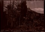
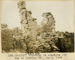
Jointing in trachyte (?), top of Carriso Mt., Ariz., 1909 (photo G-109)
1909
Image
uum_map
201
-
225
of
3,664
<
4
5
6
7
8
9
10
11
12
13
>