Home
Browse
Ask Us
Chat
Harmful Language Statement
Log in
Photo Archives
Advanced Search
About
Over 70,000 photos covering a variety of topics from Marriott Library Special Collections
Year
1872
1873
1874
1875
1876
1877
1878
1879
1880
1881
1882
1883
1884
1885
1886
1887
1888
1889
1890
1891
1892
1893
1894
1895
1896
1897
1898
1899
1900
1901
1902
1903
1904
1905
1906
1907
1908
1909
1910
1911
1912
1913
1914
1915
1916
1917
1918
1919
1920
1921
1922
1923
1924
1925
1926
1927
1928
1929
1930
1931
1932
1933
1934
1935
1936
1937
1938
1939
1940
1941
1942
1943
1944
1945
1946
1947
1948
1949
1950
1951
1952
1953
1954
1955
1956
1957
1958
1959
1960
1961
1962
1963
1964
1965
1966
1967
1968
1969
1970
1971
1972
1973
1974
1975
1976
1977
1978
1979
1980
1981
1982
1983
1984
1985
1986
1987
1988
1989
1990
1991
1992
1993
TO
1872
1873
1874
1875
1876
1877
1878
1879
1880
1881
1882
1883
1884
1885
1886
1887
1888
1889
1890
1891
1892
1893
1894
1895
1896
1897
1898
1899
1900
1901
1902
1903
1904
1905
1906
1907
1908
1909
1910
1911
1912
1913
1914
1915
1916
1917
1918
1919
1920
1921
1922
1923
1924
1925
1926
1927
1928
1929
1930
1931
1932
1933
1934
1935
1936
1937
1938
1939
1940
1941
1942
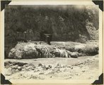
1943
1944
1945
1946
1947
1948
1949
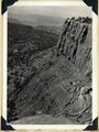
1950
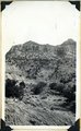
1951
1952
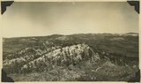
1953
1954
1955
1956
1957
1958
1959
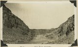
1960
1961
1962
1963
1964
1965
1966
1967
1968
1969
1970
1971
1972
1973
1974
1975
1976
1977
1978
1979
1980
1981
1982
1983
1984
1985
1986
1987
1988
1989
1990
1991
1992
1993
Type
Image
3,521
Format
image/jpeg
3,451
application/pdf
70
Collection Name
Herbert E. Gregory
3,521
Filters:
Collection Name:
"Herbert E. Gregory"
Collection:
"uum_map"
Type:
"Image"
201
-
225
of
3,521
<
4
5
6
7
8
9
10
11
12
13
>
Gallery view
Number of results to display per page
10
25
50
100
200
Sort by Relevance
Sort by Title A-Z
Sort by Title Z-A
Sort by Date Ascending
Sort by Date Descending
Sort by Last Modified Ascending
Sort by Last Modified Descending
Sort by Photo Number
Title
Collection Number And Name
Photo Number
201
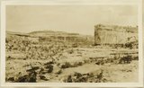
View from top of Augusta Bridge, White Canyon, Coconino sandstone
P0013 Herbert E. Gregory Photograph Collection
P0013n09_165_2032
202
View in Pahute canyon, Utah (Townsend photo), 1909
P0013 Herbert E. Gregory Photograph Collection
P0013n04_46_0585
203
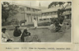
View in Papeete, Tahiti, 1915
P0013 Herbert E. Gregory Photograph Collection
P0013n13_078_9-3098
204
View in Papeete, Tahiti, 1915
P0013 Herbert E. Gregory Photograph Collection
P0013n13_078_9-3099
205
View in Parunuweap canyon between between "upper" and "lower" cascades.
P0013 Herbert E. Gregory Photograph Collection
P0013n10_093_2240
206
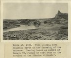
View looking down Colorado river at the Crossing of the Fathers. Showing bench at summit of Navajo SS. formed by soft beds at the horizon of the 'Marine Jurassic'
P0013 Herbert E. Gregory Photograph Collection
P0013n08_171_1671
207
View looking NE along back-slope of Capitol Reef: Fremont River gorge and terraces, upper left; Capitol Wash in middle distance jointing Pleasant Creek at left; lava boulder terrace in foreground. Wayne County, Utah, 1937.
P0013 Herbert E. Gregory Photograph Collection
P0013n10_215_2476
208
View looking S 75° W from junction of branches of Tees-Nos-Pos Canyon. White is Wingate overlain by Zuni and capped by Monzonite
P0013 Herbert E. Gregory Photograph Collection
P0013n07_018_1063
209
View NE across head of Kanab valley. Left, tilted Tertiary west of Sevier fault; right, Alton Cirque (lowland), above it, Pink Cliffs.
P0013 Herbert E. Gregory Photograph Collection
P0013n10_219_2482
210
View north along the rim of Markagunt Plateau from Brian Head. Iron County, Utah, 1937.
P0013 Herbert E. Gregory Photograph Collection
P0013n10_208_2463
211
View northwest along Capitol Reef from top of shale slope near Mulford Ranch. Chinle and Wingate (right), river terrace (left). Wayne County, Utah, 1937.
P0013 Herbert E. Gregory Photograph Collection
P0013n10_212_2471
212
View of canyon of San Juan River looking west from point near Soda basin well drilled by UT Southern Oil Co. Rocks in foreground are Pennsylvanian limestones overlain by the Rico formation at the bend of the river. The rocks on distant skyline are equivalent to the Hulgeltzo red beds and the Cedar Mesa sandstone
P0013 Herbert E. Gregory Photograph Collection
P0013n09_200_2090
213
View of the Springdale member of the Chinle, on the west end of Smithsonian Butte. Kane County, Utah, 1936.
P0013 Herbert E. Gregory Photograph Collection
P0013n10_205_2460
214
View of the Springdale member of the Chinle, on the west end of Smithsonian Butte. Kane County, Utah, 1936.
P0013 Herbert E. Gregory Photograph Collection
P0013n10_205_2459
215
View southeast from top of Brian Head. Hancock Peak in center middle distance; Paunsaugunt Plateau on left horizon. Iron County, Utah, 1936.
P0013 Herbert E. Gregory Photograph Collection
P0013n10_209_2466
216
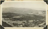
View southwest from Brian Head, showing head of Cedar Canyon, the northern Kolob Plateau, and Pine Valley Mountains (in distance). Iron County, Utah, 1937.
P0013 Herbert E. Gregory Photograph Collection
P0013n10_207_2462
217
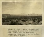
View up Colorado River from a point 3 miles below Meskin Bar, showing bench developed at the horizon of the 'Marine Jurassic'. Cliffs in background are Sentinel and McElmo formations. I measured a section of the beds at the horizon of the 'Marine Jurassic' at the farthest point up the river where the beds are visible in this view
P0013 Herbert E. Gregory Photograph Collection
P0013n08_171_1672
218
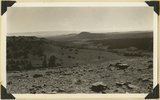
View up Colorado River from a point 3 miles east of Cottonwood Cove. Navajo Mountain in background. Terrace in foreground is at the horizon of the 'Marine Jurassic'
P0013 Herbert E. Gregory Photograph Collection
P0013n08_170_1665
219
View, Noki canyon, La Plata over Dolores (Townsend photo 1909)
P0013 Herbert E. Gregory Photograph Collection
P0013n04_43_0581
220
View, northeast base, Navajo Mt. near Junction canyon, Utah. LaPlata, McElmo (?), Cretaceous (?) strata (Townsend photo), 1909
P0013 Herbert E. Gregory Photograph Collection
P0013n04_49_0589
221
View, Todilto Park. K.C.H. photo (Photo N-M134)
P0013 Herbert E. Gregory Photograph Collection
P0013n06_001_0824
222
Views in Arch Canyon near the ranger station east of Bears Ears, UT, cut about 1,000 feet in a white sandstone supposed to be Coconino sandstone. Panorama. Lee-1925
P0013 Herbert E. Gregory Photograph Collection
P0013n09_185_2063
223
Views of Armstrong Canyon and Henry Mountains from near Bears Ears, UT. Lee-1925
P0013 Herbert E. Gregory Photograph Collection
P0013n09_186_2064
224
Views of upper and middle La Plata sandstone northwest of Bluff, UT
P0013 Herbert E. Gregory Photograph Collection
P0013n09_192_2070
225
Virgin River at La Verkin Hot Springs. Shacks are shelters over intake pipes leading to the pool quarter of a mile down the river. Washington County, Utah, 1937.
P0013 Herbert E. Gregory Photograph Collection
P0013n10_202_2452
201
-
225
of
3,521
<
4
5
6
7
8
9
10
11
12
13
>