|
|
Title | Collection Number And Name | Photo Number |
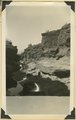
| 201 |
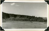 |
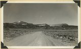
Bed of little Creek, sunk 10 feet to 40 feet into alluvium since 1890, Kane County, UT, 1939 | P0013 Herbert E. Gregory Photograph Collection | P0013n11_041_2591 |
| 202 |
 |
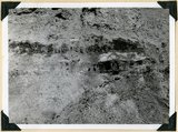
Bedded clays and lime silts. Pleistocene(?) lacustrine deposits overlain by basalt, Castro Canyon. Garfield County, UT, 1940 | P0013 Herbert E. Gregory Photograph Collection | P0013n11_130_2721 |
| 203 |
 |
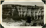
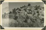
Big Plains, west dipping surface eroded on east dipping Chinle beds, now coated with coalescing fans. Little Creek Terrace in right background, Kane County, UT, 1939 | P0013 Herbert E. Gregory Photograph Collection | P0013n11_088_2669 |
| 204 |
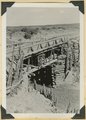 |
Bridge built by C.C.C. across recently eroded wash, near Pipe Springs. Mohave County, AZ. 1939 | P0013 Herbert E. Gregory Photograph Collection | P0013n11_098_2686 |
| 205 |
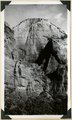 |
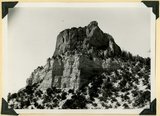
Cable Mountain, Navajo sandstone. Location of East Rim trail (center). Zion National Park | P0013 Herbert E. Gregory Photograph Collection | P0013n11_025_2563 |
| 206 |
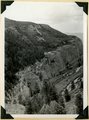 |
Camp Creek near its mouth in Hurricane Cliffs. Navajo sandstone overlain by Carmel, Entrada, Curtis and Winsor. Pine Valley mountains (right distance), Washington County, UT, 1939 | P0013 Herbert E. Gregory Photograph Collection | P0013n11_054_2614 |
| 207 |
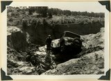 |
Car washed into a ravine by flood. Skutumpah-Swallow Park road | P0013 Herbert E. Gregory Photograph Collection | P0013n11_121_2711 |
| 208 |
 |
Carmel (bottom), Entrada (slope), Curtis (cliff of gypsum) and Winsor formation (top slope), Meadow Brook Canyon, Kane County, UT, 1939 | P0013 Herbert E. Gregory Photograph Collection | P0013n11_046_2600 |
| 209 |
 |
Carmel formation (cliff) at head of Flume Canyon upthrow (east) side of Sevier fault which trends northeasterly. Cretaceous formations (background) at level of Jurassic. Kane County, UT. 1939 | P0013 Herbert E. Gregory Photograph Collection | P0013n11_048_2603 |
| 210 |
 |
Carmel formation and Entrada (upper right) near mouth of Deep Creek. Washington County, UT, 1940 | P0013 Herbert E. Gregory Photograph Collection | P0013n11_138_2732 |
| 211 |
 |
Carmel formation in branch of Flume Canyon. About half of total shown. Kane County, UT. 1939 | P0013 Herbert E. Gregory Photograph Collection | P0013n11_048_2604 |
| 212 |
 |
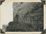
Carmel formation in Mineral Gulch. Typical arrangement of shaly and massive beds, Kane County, UT. 1939 | P0013 Herbert E. Gregory Photograph Collection | P0013n11_043_2595 |
| 213 |
 |
Casto Bluff head of Casto Canyon southwest edge of Sevier Plateau. Acidic lava underlain by Sevier(?) formation, Garfield County, UT, 1941 | P0013 Herbert E. Gregory Photograph Collection | P0013n11_148_2751 |
| 214 |
 |
Casto Bluff, detail thick lava beds in Sevier(?) formation | P0013 Herbert E. Gregory Photograph Collection | P0013n11_149_2754 |
| 215 |
 |
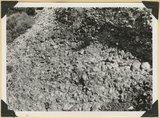
Castro Bluff, detail pumice conglomerate in Sevier formation | P0013 Herbert E. Gregory Photograph Collection | P0013n11_150_2755 |
| 216 |
 |
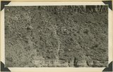
Castro Bluff, detail thin beds (upper) in Sevier(?) formation | P0013 Herbert E. Gregory Photograph Collection | P0013n11_149_2753 |
| 217 |
 |
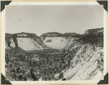
Castro Bluff, view looking westward from its base. Terrace developed in the Sevier(?) formation at the top of the Wasatch formation | P0013 Herbert E. Gregory Photograph Collection | P0013n11_150_2756 |
| 218 |
 |
Cave Canyon walls of Navajo sandstone, above them shale and Temple Cap member forms second cliff, capped in turn with Carmel limestone. Zion National Park | P0013 Herbert E. Gregory Photograph Collection | P0013n11_027_2567 |
| 219 |
 |
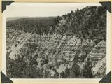
Cedar Ridge. Cap of Shinarump conglomerate and upper Moenkopi extending south from Vermillion Cliffs onto Uinkaret Plateau west of Pipe Wash, Mohave County, AZ. 1939 | P0013 Herbert E. Gregory Photograph Collection | P0013n11_099_2687 |
| 220 |
 |
Cliffs north of highway west of Bicknell (right center). Moenkopi, Shinarump, Chinle, Wingate. Plain in foreground borders Fremont River. Wayne County, UT, 1936 | P0013 Herbert E. Gregory Photograph Collection | P0013n11_035_2581 |
| 221 |
 |
Coal in the Dakota or basal Tropic; Coal hill east side Meadow Brook. Kane County, UT | P0013 Herbert E. Gregory Photograph Collection | P0013n11_023_2558 |
| 222 |
 |
Conglomerates, base of Timpoweep member of the Moenkopi Tarper Creek. Washington County, UT. 1941 | P0013 Herbert E. Gregory Photograph Collection | P0013n11_160_2775 |
| 223 |
 |
Consolidated river gravel (Wisconsin age?) overlying eroded Entrada(?) 300 feet above Paria River 2 miles south of Cannonville, Kane County, UT, 1939 | P0013 Herbert E. Gregory Photograph Collection | P0013n11_038_2588 |
| 224 |
 |
Contact of fossiliferous Kaibab (base) and fossiliferous Moenkopi (top), Isom Wash, Washington Co., UT, 1939. Exact contact not placed | P0013 Herbert E. Gregory Photograph Collection | P0013n11_038_2587 |
| 225 |
 |
Contact of old and recent basalt flows near head of Gould Canyon, Washington County, UT, 1939 | P0013 Herbert E. Gregory Photograph Collection | P0013n11_042_2593 |