Home
Browse
Ask Us
Chat
Harmful Language Statement
Log in
Advanced Search
Year
1872
1873
1874
1875
1876
1877
1878
1879
1880
1881
1882
1883
1884
1885
1886
1887
1888
1889
1890
1891
1892
1893
1894
1895
1896
1897
1898
1899
1900
1901
1902
1903
1904
1905
1906
1907
1908
1909
1910
1911
1912
1913
1914
1915
1916
1917
1918
1919
1920
1921
1922
1923
1924
1925
1926
1927
1928
1929
1930
1931
1932
1933
1934
1935
1936
1937
1938
1939
1940
1941
1942
1943
1944
1945
1946
1947
1948
1949
1950
1951
1952
1953
1954
1955
1956
1957
1958
1959
1960
1961
1962
1963
1964
1965
1966
1967
1968
1969
1970
1971
1972
1973
1974
1975
1976
1977
1978
1979
1980
1981
1982
1983
1984
1985
1986
1987
1988
1989
1990
1991
1992
1993
TO
1872
1873
1874
1875
1876
1877
1878
1879
1880
1881
1882
1883
1884
1885
1886
1887
1888
1889
1890
1891
1892
1893
1894
1895
1896
1897
1898
1899
1900
1901
1902
1903
1904
1905
1906
1907
1908
1909
1910
1911
1912
1913
1914
1915
1916
1917
1918
1919
1920
1921
1922
1923
1924
1925
1926
1927
1928
1929
1930
1931
1932
1933
1934
1935
1936
1937
1938
1939
1940
1941
1942
1943
1944
1945
1946
1947
1948
1949
1950
1951
1952
1953
1954
1955
1956
1957
1958
1959
1960
1961
1962
1963
1964
1965
1966
1967
1968
1969
1970
1971
1972
1973
1974
1975
1976
1977
1978
1979
1980
1981
1982
1983
1984
1985
1986
1987
1988
1989
1990
1991
1992
1993
Type
Image
3,451
Image/StillImage
143
Format
image/jpeg
3,594
Collection
Photo Archives
3,451
UAIDA Main Collection
143
Filters:
Collection Name:
"Herbert E. Gregory"
Format:
"image/jpeg"
201
-
225
of
3,594
<
4
5
6
7
8
9
10
11
12
13
>
Gallery view
Number of results to display per page
10
25
50
100
200
Sort by Relevance
Sort by Title A-Z
Sort by Title Z-A
Sort by Date Ascending
Sort by Date Descending
Sort by Last Modified Ascending
Sort by Last Modified Descending
Title
Date
Type
Setname
201
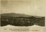
Abajo Mountains from southwest, [Probably from southern end of Elk Ridge]
1915
Image
uum_map
202
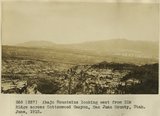
Abajo Mountains looking east from Elk Ridge across Cottonwood Canyon, San Juan County, Utah. June, 1915.
1915
Image
uum_map
203
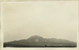
Abajo Mountains looking northwest from Blanding. Monticello Road. San Juan County, UT, 1928
1928
Image
uum_map
204
Abancay to La Estrella. Concacha. Nearer view of the same.
1911; 1912; 1915
Image
uum_map
205
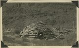
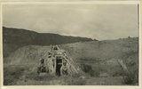
Abandoned hogan on east side of the San Juan some 3 miles above the mouth of Pinte Creek. San Juan County, UT. 1921
1921
Image
uum_map
206
Abandoned Logan, San Juan River, 10 miles above mouth
1920; 1921; 1922; 1923; 1924; 1925; 1926; 1927; 1928; 1929; 1930
Image
uum_map
207
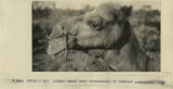
Afghan camel used extensively in central Australia, 1916
1916
Image
uum_map
208
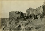
After the dance, Walpi, AZ
1915
Image
uum_map
209
Agathla (John Wetherill photo)
1910
Image
uum_map
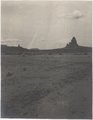
210
Agathla and Slim (Queen) Rock, Ariz., from S.E. (Photo G144)
1910
Image
uum_map
211
Agathla and Slim (Queen) Rock, Ariz., from S.E. (Photo G144)
1910
Image
uum_map
212
Agathla and Slim (Queen) Rock, Ariz., from S.E. (Photo N-M86)
1910
Image
uum_map
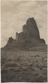
213
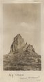
Agathla, volcanic neck, between Chinlee, Ariz. and Oljato, Utah, 1910 (Photo G145)
1910
Image
uum_map
214
Agathla, volcanic neck, between Chinlee, Ariz. and Oljato, Utah, 1910 (Photo G145)
1910
Image
uum_map
215
Agathla, volcanic neck, between Chinlee, Ariz. and Oljato, Utah, 1910 (Photo G146)
1910
Image
uum_map
216
Agathla, volcanic neck, between Chinlee, Ariz. and Oljato, Utah, 1910 (Photo G146)
1910
Image
uum_map
217
Agathla, volcanic neck, between Chinlee, Ariz. and Oljato, Utah, 1910 (same as G145, Townsend photo)
1910
Image
uum_map
218
Alcove in DeChelly sandstone near Mule Ear, 1914
1914
Image
uum_map
219
Alcove in La Plata sandstone, Todilto Park (Photo G382)
1913
Image
uum_map
220
Alhambra dike south of Goodridge, Utah. (EGW)
1909
Image
uum_map
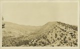
221
Allen Canyon country outer slope of Comb monocline. San Juan County, UT, 1925. Wall of ridge includes Moenkopi and Chinle, head of Whiskers Creek
1925
Image
uum_map
222
Allen Canyon country outer slope of Comb monocline. San Juan County, UT, 1925. Wall of ridge includes Moenkopi and Chinle, head of Whiskers Creek
1925
Image
uum_map
223
Alluvial fill exposed by recent erosion. Comb Wash, San Juan County, Utah, 1929.
1929
Image
uum_map
224
Alluvial terraces made since 1900, Johnson Creek, Kane County, UT, 1939
1939
Image
uum_map
225
Alluvial terraces on Kanab Creek near mouth of Tiny Canyon, Kane County, UT. 1939. Excavated since 1882
1939
Image
uum_map
201
-
225
of
3,594
<
4
5
6
7
8
9
10
11
12
13
>