Home
Browse
Ask Us
Chat
Harmful Language Statement
Log in
Advanced Search
Year
1867
1868
1869
1870
1871
1872
1873
1874
1875
1876
1877
1878
1879
1880
1881
1882
1883
1884
1885
1886
1887
1888
1889
1890
1891
1892
1893
1894
1895
1896
1897
1898
1899
1900
1901
1902
1903
1904
1905
1906
1907
1908
1909
1910
1911
1912
1913
1914
1915
1916
1917
1918
1919
1920
1921
1922
1923
1924
1925
1926
1927
1928
1929
1930
1931
1932
1933
1934
1935
1936
1937
1938
1939
1940
1941
1942
1943
1944
1945
1946
1947
1948
1949
1950
1951
1952
1953
1954
1955
1956
1957
1958
1959
1960
1961
1962
1963
1964
1965
1966
1967
1968
1969
1970
1971
1972
1973
1974
1975
1976
1977
1978
1979
1980
1981
1982
1983
1984
1985
1986
1987
1988
1989
1990
1991
1992
1993
1994
1995
1996
1997
1998
1999
2000
2001
2002
2003
2004
2005
2006
2007
2008
2009
2010
2011
2012
2013
2014
2015
2016
2017
2018
2019
2020
2021
2022
2023
2024
TO
1867
1868
1869
1870
1871
1872
1873
1874
1875
1876
1877
1878
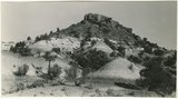
1879
1880
1881
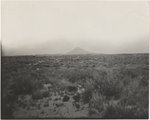
1882
1883
1884
1885
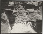
1886
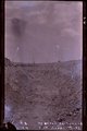
1887
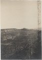
1888
1889
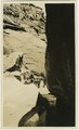
1890
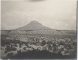
1891
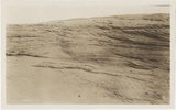
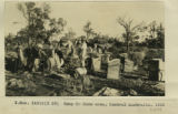
1892
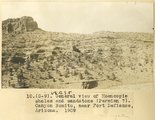
1893
1894
1895
1896
1897
1898
1899
1900
1901
1902
1903
1904
1905
1906
1907
1908
1909
1910
1911
1912
1913
1914
1915
1916
1917
1918
1919
1920
1921
1922
1923
1924
1925
1926
1927
1928
1929
1930
1931
1932
1933
1934
1935
1936
1937
1938
1939
1940
1941
1942
1943
1944
1945
1946
1947
1948
1949
1950
1951
1952
1953
1954
1955
1956
1957
1958
1959
1960
1961
1962
1963
1964
1965
1966
1967
1968
1969
1970
1971
1972
1973
1974
1975
1976
1977
1978
1979
1980
1981
1982
1983
1984
1985
1986
1987
1988
1989
1990
1991
1992
1993
1994
1995
1996
1997
1998
1999
2000
2001
2002
2003
2004
2005
2006
2007
2008
2009
2010
2011
2012
2013
2014
2015
2016
2017
2018
2019
2020
2021
2022
2023
2024
Type
Image
3,523
Text
287
Image/StillImage
149
Sound
5
Format
image/jpeg
3,602
application/pdf
1,179
Collection
44th Bomb Group - 8 Ball Tails Magazine
1
Alan K Engen Papers
2
American West Center Research Projects
12
Angus Munn Woodbury Papers
1
Athletics
13
Charles James Nabors Papers
3
Civilian Conservation Corps Newslette...
1
Classified Photographs
7
College of Law Publications
54
College of Nursing
13
Colorado Riverbed Case
2
Continuum
7
Cycling Utah
1
Electronic University Archive
49
Elias Hicks Blackburn Papers, 1848-1908
2
Everett L. Cooley Oral History Project
15
Glen Canyon
1
Graduate Nursing Project
1
Hinckley Journal of Politics
1
Historic and Prehistoric Publications
133
Honors Theses Closed Archive
1
Honors Theses Open Access
4
Illuminations
2
Intermountain Ski Instructors Associa...
10
Juanita Brooks Papers
3
Kem C. Gardner Policy Institute Colle...
1
Linford and Richards Family Collection
4
Manuscripts
4
Marriner S. Eccles Papers
19
Marriott Digital Publishing Archive
1
Marriott Library Digital Stacks
1
Marriott Library Items
1
Midvale Museum
1
Mormon Settlement in Arizona
2
NOVEL - Journal of Neuro-Ophthalmology
1
Neighborhood Partners
1
Photo Archives
3,525
Public Affairs of Health Sciences Center
4
Rare Books Collection
7
Theater Programs Collection, 1866-1995
1
Theses & Dissertations
37
UAIDA Main Collection
144
UMFA Docent Archive
1
UScholar Works
7
University of Utah Board of Regents M...
2
University of Utah Press Open Access ...
5
Uranium Oral Histories
1
Utah City Directories Collection
557
Utah Historic Building Records
60
Utah Historical Society Oral History ...
1
Utah Medical Association Bulletin
13
Utah National Register Nomination Forms
1
Utah Pharmacy Digest
6
Utah State Board Of Regents
6
Utah's Urban Pioneer Folk Music Reviv...
1
Utonian Yearbooks
13
Western Waters AZ. vs CA.
1
Western Waters Documents
4
Western Waters NEH
9
More
176
-
200
of
4,781
<
3
4
5
6
7
8
9
10
11
12
>
Gallery view
Number of results to display per page
10
25
50
100
200
Sort by Relevance
Sort by Title A-Z
Sort by Title Z-A
Sort by Date Ascending
Sort by Date Descending
Sort by Last Modified Ascending
Sort by Last Modified Descending
Title
Date
Type
Setname
176
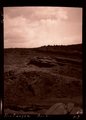
Moenkopi formation: Shnabkaib member (lower part), upper red sandstone (upper middle), Shinarump conglomerate (top). East side of Seamans Wash, Kane County, UT. 1943
1943
Image
uum_map
177
Monocline, LaPlata over Dolores east face of Skeleton Mesa, 15± mi. north of Marsh Pass, Ariz., 1910 (Photo G154)
1910
Image
uum_map
178
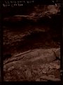
Mud cracks, McElmos valley, Colorado. 1910 (Photo G-122)
1910
Image
uum_map
179
One of the monuments, Monument Pass, Utah. Moencopie strata. 1910 (Photo G138)
1910
Image
uum_map
180
Same as 627 (LaPlata cross-bedding, Totocong, Photo G332)
1913
Image
uum_map
181
Same as Photo G254. 1911 (White Cone, Photo G255)
1911
Image
uum_map
182
Sevier River formation overlaid by basalt near mouth of Corral Creek on Highway 89, 2 miles east of Panguitch. Garfield County, UT. 1944
1944
Image
uum_map
183
Slim Rock or "the Queen," LaPlata outlier on Dolores, near Agathla Needle, Ariz., looking southwest, 1910 (Photo G152)
1910
Image
uum_map
184
Structure, Dolores and La Plata, looking west from Oljato, Utah, 1910 (Photo N-M84)
1910
Image
uum_map
185
Totocong Spg., Chinlee valley, below Tsenakahn. LaPlata cross-bedding (Photo G331)
1913
Image
uum_map
186
Unconformity between Moenkopi formation (lower part) and Shinarump conglomerate. Upper Chinle beds, middle top. Near mouth of Road Canyon. Kane County, UT. 1943
1943
Image
uum_map
187
Unconformity. Base of Dakota in section VI, 15. West of Manuelito, NM. 1911 (Photo G194)
1911
Image
uum_map
188
View looking west across Comb Wash at Navajo Springs, 12± miles west of Bluff, UT. 1910 (Photo G135)
1910
Image
uum_map
189
View north along dike in Moses Rock garnet field, 1914
1914
Image
uum_map
190
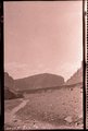
Warm Creek Canyon, June, 1915.
1915
Image
uum_map
191
White Cone. 1911 (Photo G257)
1911
Image
uum_map
192
Camp in dune areas, Central Australia, 1916
1916
Image
uum_map
193
General view of Moencopie shales and sandstone (Permian?). Canyon Bonito, near Fort Defiance, Arizona, 1909
1909
Image
uum_map
194
Same as G-85 (Many Waters Lake, Arizona, photo G-86)
1909
Image
uum_map
195
Arroyo in cienega, St. Michaels, Ariz. (negative for G-3)
1909
Image
uum_map
196
Black Creek Valley, Arizona (negative for photo G-11)
1909
Image
uum_map
197
Blue Canyon, Ariz. (negative for G-5)
1909
Image
uum_map
198
Blue Canyon, Ft. Defiance, Ariz. (negative for G-4)
1909
Image
uum_map
199
Canyon Bonito, Ariz. (negative for photo G-6)
1909
Image
uum_map
200
Concretions (Dakota?), Hlohala, Ariz., 1909 (photo G-106)
1909
Image
uum_map
176
-
200
of
4,781
<
3
4
5
6
7
8
9
10
11
12
>