|
|
Title | Collection Number And Name | Photo Number |
| 176 |
 |
Dike or volcanic neck no. 2, Laguna Creek valley, 10+ mi. southeast of Agathla Needle, 1910 (Photo NM89) | P0013 Herbert E. Gregory Photograph Collection | P0013n04_27_0560 |
| 177 |
 |
Dike or volcanic neck no. 2, Laguna Creek valley, 10+ mi. southeast of Agathla Needle, 1910 (Photo by C.C. Colville) | P0013 Herbert E. Gregory Photograph Collection | P0013n04_28_0561 |
| 178 |
 |
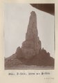
Dike no. 4A 2+ mil. southeast of Cha-ez Kla, Ariz., 1910. | P0013 Herbert E. Gregory Photograph Collection | P0013n04_28_0562 |
| 179 |
 |
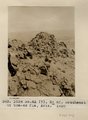
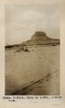
Slim Rock or "the Queen," LaPlata outlier on Dolores, near Agathla Needle, Ariz., looking southwest, 1910 (Photo G152) | P0013 Herbert E. Gregory Photograph Collection | P0013n04_29_0563 |
| 180 |
 |
Slim Rock or "the Queen," LaPlata outlier on Dolores, near Agathla Needle, Ariz., looking southwest, 1910 (Photo G152) | P0013 Herbert E. Gregory Photograph Collection | P0013n04_29_0563 |
| 181 |
 |
Slim Rock or "The Queen" from the east (Photo G153) | P0013 Herbert E. Gregory Photograph Collection | P0013n04_29_0564 |
| 182 |
 |
Slim Rock or "The Queen" from the east (Photo G153) | P0013 Herbert E. Gregory Photograph Collection | P0013n04_29_0564 |
| 183 |
 |
Slim Rock or "the Queen," LaPlata outlier on Dolores, near Agathla Needle, Ariz., looking southwest, 1910 (Photo N-M91) | P0013 Herbert E. Gregory Photograph Collection | P0013n04_30_0565 |
| 184 |
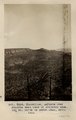 |
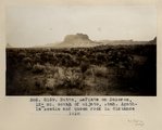
Monocline, LaPlata over Dolores east face of Skeleton Mesa, 15+ mi. north of Marsh Pass, Ariz., 1910 | P0013 Herbert E. Gregory Photograph Collection | P0013n04_30_0566 |
| 185 |
 |
Monocline, LaPlata over Dolores east face of Skeleton Mesa, 15± mi. north of Marsh Pass, Ariz., 1910 (Photo G154) | P0013 Herbert E. Gregory Photograph Collection | P0013n04_30_0566 |
| 186 |
 |
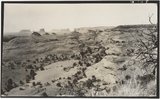
Marsh Pass, Ariz., looking northeast, LaPlata sandstone dipping southeast under Black Mesa (Photo G155) | P0013 Herbert E. Gregory Photograph Collection | P0013n04_31_0567 |
| 187 |
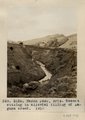 |
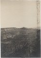
Marsh Pass, Ariz. Recent cutting in alluvial filling of Laguna Creek, 1910 (Photo G156) | P0013 Herbert E. Gregory Photograph Collection | P0013n04_31_0568 |
| 188 |
 |
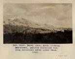
General view of upper Moencopie strata, looking northeast toward Monument Pass. Taken from a point 8± mi. northeast of Agathla Needle, Ariz., 1910 (Photo G158) | P0013 Herbert E. Gregory Photograph Collection | P0013n04_32_0560A |
| 189 |
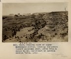 |
General view of upper Moencopie strata, looking northeast toward Monument Pass. Taken from a point 8+ mi. northeast of Agathla Needle, Ariz., 1910 (Photo G158) | P0013 Herbert E. Gregory Photograph Collection | P0013n04_32_0560a |
| 190 |
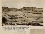 |
Cross-bedding, Moencopie (?) strata, 6+ mi. northeast of Agathla Needle, Ariz., 1910 (Photo G157) | P0013 Herbert E. Gregory Photograph Collection | P0013n04_32_0569 |
| 191 |
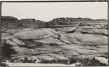 |
Cross-bedding, Moencopie (?) strata, 6± mi. northeast of Agathla Needle, Ariz., 1910 (Photo G157) | P0013 Herbert E. Gregory Photograph Collection | P0013n04_32_0569 |
| 192 |
 |
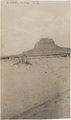
Butte, LaPlata on Dolores, 12+ mi. south of Oljato, Utah. Agathla Needle and QueenRock in distance, 1910 (Photo G159) | P0013 Herbert E. Gregory Photograph Collection | P0013n04_33_0561a |
| 193 |
 |
Butte, LaPlata on Dolores, 12± mi. south of Oljato, Utah. Agathla Needle in distance, 1910 | P0013 Herbert E. Gregory Photograph Collection | P0013n04_33_0562A |
| 194 |
 |
Butte, LaPlata on Dolores, 12+ mi. south of Oljato, Utah. Agathla Needle in distance, 1910 (Photo N-M91A) | P0013 Herbert E. Gregory Photograph Collection | P0013n04_33_0562a |
| 195 |
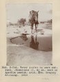 |
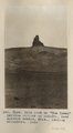
Water pocket on bare surface (Moencopie?), 4+ mi. east of Agathla Needle, Ariz. Mrs. Gregory drinking, 1910 (Photo N-M92) | P0013 Herbert E. Gregory Photograph Collection | P0013n04_34_0563a |
| 196 |
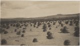 |
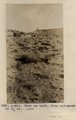
Navajo dry farming, Laguna Creek valley near Marsh Pass, Ariz., 1910 (Photo G160) | P0013 Herbert E. Gregory Photograph Collection | P0013n04_34_0564A |
| 197 |
 |
Navajo dry farming, Laguna Creek valley near Marsh Pass, Ariz., 1910 (Photo G160) | P0013 Herbert E. Gregory Photograph Collection | P0013n04_34_0564a |
| 198 |
 |
Camp 3+ mi. east of Agathla Needle, Ariz. (Photo N-M93) | P0013 Herbert E. Gregory Photograph Collection | P0013n04_34_0565a |
| 199 |
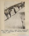 |
Trail, bare rock, angle 30 degrees, 10+ mil. northeast of Agathla Needle (Photo N-M94) | P0013 Herbert E. Gregory Photograph Collection | P0013n04_35_0566a |
| 200 |
 |
Butte, junction Sagy canyon with middle of East Branch, Ariz., 1910 (Photo G162) | P0013 Herbert E. Gregory Photograph Collection | P0013n04_35_0567a |