Home
Browse
Ask Us
Chat
Harmful Language Statement
Log in
Advanced Search
Year
1872
1873
1874
1875
1876
1877
1878
1879
1880
1881
1882
1883
1884
1885
1886
1887
1888
1889
1890
1891
1892
1893
1894
1895
1896
1897
1898
1899
1900
1901
1902
1903
1904
1905
1906
1907
1908
1909
1910
1911
1912
1913
1914
1915
1916
1917
1918
1919
1920
1921
1922
1923
1924
1925
1926
1927
1928
1929
1930
1931
1932
1933
1934
1935
1936
1937
1938
1939
1940
1941
1942
1943
1944
1945
1946
1947
1948
1949
1950
1951
1952
1953
1954
1955
1956
1957
1958
1959
1960
1961
1962
1963
1964
1965
1966
1967
1968
1969
1970
1971
1972
1973
1974
1975
1976
1977
1978
1979
1980
1981
1982
1983
1984
1985
1986
1987
1988
1989
1990
1991
1992
1993
TO
1872
1873
1874
1875
1876
1877
1878
1879
1880
1881
1882
1883
1884
1885
1886
1887
1888
1889
1890
1891
1892
1893
1894
1895
1896
1897
1898
1899
1900
1901
1902
1903
1904
1905
1906
1907
1908
1909
1910
1911
1912
1913
1914
1915
1916
1917
1918
1919
1920
1921
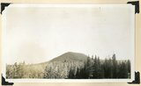
1922
1923
1924
1925
1926
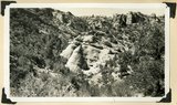
1927
1928
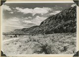
1929
1930
1931
1932
1933
1934
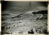
1935
1936
1937
1938
1939
1940
1941
1942
1943
1944
1945
1946
1947
1948
1949
1950
1951
1952
1953
1954
1955
1956
1957
1958
1959
1960
1961
1962
1963
1964
1965
1966
1967
1968
1969
1970
1971
1972
1973
1974
1975
1976
1977
1978
1979
1980
1981
1982
1983
1984
1985
1986
1987
1988
1989
1990
1991
1992
1993
Type
Image
3,521
Image/StillImage
143
Format
image/jpeg
3,594
application/pdf
70
Collection
Photo Archives
3,521
UAIDA Main Collection
143
Filters:
Collection Name:
"Herbert E. Gregory"
176
-
200
of
3,664
<
3
4
5
6
7
8
9
10
11
12
>
Gallery view
Number of results to display per page
10
25
50
100
200
Sort by Relevance
Sort by Title A-Z
Sort by Title Z-A
Sort by Date Ascending
Sort by Date Descending
Sort by Last Modified Ascending
Sort by Last Modified Descending
Title
Date
Type
Setname
176
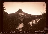
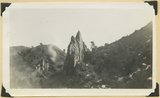
White Cone ("Tabbtimp"), outlier of Navajo sandstone at head of Starlight Canyon. Wall of Paria Canyon (lower right). Kane County, Utah, 1943.
1943
Image
uum_map
177
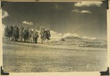
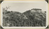
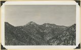
"Pryor Knoll, eroded basaltic cone and lava flows over Cretaceous rocks. View looking northwest. Western edge of Kolob Terrace. Just back of the yellow pines are the cliffs at the head of the westward flowing Shurtz Creek. Iron County, UT, 1942
1942
Image
uum_map
178
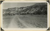
Arrangement of formations at Squaw Canyon along the line of the Kanarra fold. Triassic; Navajo upper Jurassic (Carmel, Entrada, Curtis, Winsor); Cretaceous. Steep dips of lower formations progressively flatten eastward (right). Iron County, UT, 1942
1942
Image
uum_map
179
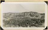
Basalt flow from Horsetail Mountain near its termination (eastward; right), Iron County, UT, 1942
1942
Image
uum_map
180
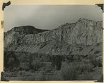
Black Ledge. Cliff of rhyolite that for about 20 miles forms the rim of the Markagunt Plateau. The escarpment is the upthrown side of a fault concealed by the talus. Hoosier Lake, Iron County, UT, 1942
1942
Image
uum_map
181
Black Mountain culminating in Richardson Peak (altitude 9900 feet), viewed from southwest. Eroded crater and extensive basaltic flows overlying Cretaceous and Tertiary sediments. View looking north east edge of Kolob Terrace. Iron County, UT, 1942
1942
Image
uum_map
182
Braffit Point. Mass of conglomerate in the Kaiparowits formation, branch of Parowan Canyon, Iron County, UT, 1942
1942
Image
uum_map
183
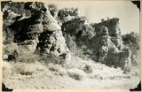
Brian Head formation capped by lava. Branch of Limekiln Canyon. Garfield County, UT. 1942
1942
Image
uum_map
184
Carmel formation. Coal Canyon, Iron County, UT. 1942
1942
Image
uum_map
185
Carmel formation. Coal Canyon, Iron County, UT. 1942
1942
Image
uum_map
186
Conglomerate and underlying arkosic sandstone, Kaiparowits formation, Bowery Canyon, Iron County, UT, 1942
1942
Image
uum_map
187
Conglomerate within the Wasatch formation (top and bottom). Bowery Canyon. Iron County, UT, 1942
1942
Image
uum_map
188
Face of Hurricane Cliffs between Kanarra and Murie Creeks. Westward dipping lower Moenkopi strata. Edge of South Hills (left center), Square Mountain (left distance). Iron County, UT, 1942
1942
Image
uum_map
189
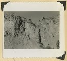
Fault contact of Carmel (right) and Curtis (left). Coal Canyon above the mouth of Rocky Hollow. Iron County, UT, 1942
1942
Image
uum_map
190
Fault near the mouth of Maple Canyon looking north, upthrown block at left. Iron County, UT, 1942
1942
Image
uum_map
191
Fault, Wasatch limestone (extreme right) in horizontal contact with undifferentiated Cretaceous. Parowan Canyon. Iron County, UT
1941
Image
uum_map
192
Hancock Peak. Volcanic cone, Iron County, UT, 1942
1942
Image
uum_map
193
Hurricane Cliffs looking north across mouth of Swayne Creek. Iron County
1941; 1942
Image
uum_map
194
Hurricane Cliffs, formed by westward dipping Moenkopi strata involved in the Kanarra fold. Hurricane fault passes along the base and through the valley of Murie Creek (left); thick alluvium on the downthrown block (foreground). Iron County, UT, 1942
1942
Image
uum_map
195
Kaiparowits formation (Cretaceous) overlain by the Wasatch Tertiary. Bowery Canyon, Iron County, 1942
1942
Image
uum_map
196
Kaiparowits formation (Cretaceous) overlain by the Wasatch Tertiary. Bowery Canyon, Iron County, 1942
1942
Image
uum_map
197
Kaiparowits formation (Cretaceous) overlain by the Wasatch Tertiary. Bowery Canyon, Iron County, 1942
1942
Image
uum_map
198
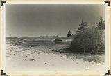
Lake like no 2837, about a half mile down valley
1942
Image
uum_map
199
Log Hollow fault (Cretaceous), Kaiparowits formation, on upthrown side (middle and right) in contact with Tertiary (left). Estimated displacement 700 feet. Bowery Canyon, Iron County, UT. 1942
1942
Image
uum_map
200
Moenkopi beds upturned in the Kanarra fold and broken by a fault. Lawrence Canyon, Iron County, UT, 1942
1942
Image
uum_map
176
-
200
of
3,664
<
3
4
5
6
7
8
9
10
11
12
>