|
|
Title | Collection Number And Name | Photo Number |
| 176 |
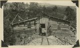 |
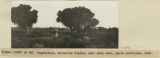
Tunnel house, Dream Mine, Johnson Creek. S. J. Houser, owner. Abajo Mountains. Utah, San Juan, 1915. | P0013 Herbert E. Gregory Photograph Collection | P0013n10_028_2133 |
| 177 |
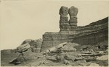 |
The Twins at Bluff, UT, U.S.G.S Jackson, taken about 1875 | P0013 Herbert E. Gregory Photograph Collection | P0013n09_158_2020 |
| 178 |
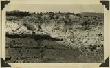 |
Unconformity west of Paria. Middle white, Shinarump; lower left, dark, Moenkopi; upper beds, Chinle. Kane County, Utah, 1937. | P0013 Herbert E. Gregory Photograph Collection | P0013n10_193_2432 |
| 179 |
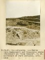 |
Unconformity, quartzite (pre-Cambrian?) and Moencopie shale (Permian?) at "Blue Canyon," 2± mil. northwest of Fort Defiance, Ariz., 1909 (photo G-5) | P0013 Herbert E. Gregory Photograph Collection | P0013n02_003_200 |
| 180 |
 |
Unconformity. McElmo-Dakota. Blue Canon. | P0013 Herbert E. Gregory Photograph Collection | P0013n07_027_1073 |
| 181 |
 |
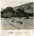
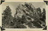
Upper La Plata sandstone (light-colored), Johnson Creek, Abajo Mountains. Utah, San Juan, 1915. | P0013 Herbert E. Gregory Photograph Collection | P0013n10_030_2138 |
| 182 |
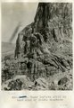 |
Upper LaPlata cliff on west side of Navaho Mountain | P0013 Herbert E. Gregory Photograph Collection | P0013n07_032_1078 |
| 183 |
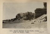 |
Upper member of La Plata formation at Bluff, Utah. | P0013 Herbert E. Gregory Photograph Collection | P0013n04_74_0647 |
| 184 |
 |
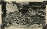
Upturned Dakota sandstone, Johnson Creek, Abajo Mountains. Utah, San Juan, 1915. | P0013 Herbert E. Gregory Photograph Collection | P0013n10_031_2139 |
| 185 |
 |
Upturned Dakota sandstone. First ridge south of Pole Creek, at base of Abajo Peak. Dip 41° E. Abajo Mountains. Utah, San Juan, 1915. | P0013 Herbert E. Gregory Photograph Collection | P0013n10_037_2152 |
| 186 |
 |
Urubamba to Cuzco. Cargo trains of relics from Machu Picchu. | P0013 Herbert E. Gregory Photograph Collection | P0013n13_060_9-3063 |
| 187 |
 |
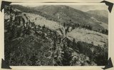
Valley that drains Red Lake. Looking north from 2 miles north of Moencopie Canon. | P0013 Herbert E. Gregory Photograph Collection | P0013n07_044_1090 |
| 188 |
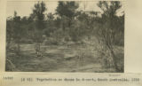 |
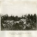
Vegetation on dunes in desert, South Australia, 1916 | P0013 Herbert E. Gregory Photograph Collection | P0013n13_124_9-3235 |
| 189 |
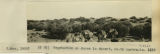 |
Vegetation on dunes in desert, South Australia, 1916 | P0013 Herbert E. Gregory Photograph Collection | P0013n13_125_9-3239 |
| 190 |
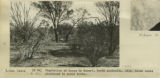 |
Vegetation on dunes in desert, South Australia, 1916 | P0013 Herbert E. Gregory Photograph Collection | P0013n13_126_9-3243 |
| 191 |
 |
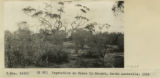
Vegetation on dunes in desert, South Australia, 1916 | P0013 Herbert E. Gregory Photograph Collection | P0013n13_125_9-3240 |
| 192 |
 |
Vegetation on dunes in desert, South Australia, 1916 | P0013 Herbert E. Gregory Photograph Collection | P0013n13_125_9-3238 |
| 193 |
 |
Vegetation on dunes in desert, South Australia, 1916 | P0013 Herbert E. Gregory Photograph Collection | P0013n13_124_9-3236 |
| 194 |
 |
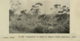
Vegetation on top of Navaho Mountain | P0013 Herbert E. Gregory Photograph Collection | P0013n07_049_1095 |
| 195 |
 |
Vegetation over most of Nullarbor Plains, South Australia, 1916 | P0013 Herbert E. Gregory Photograph Collection | P0013n13_127_9-3244 |
| 196 |
 |
Vegetation over most of Nullarbor Plains, South Australia, 1916 | P0013 Herbert E. Gregory Photograph Collection | P0013n13_127_9-3245 |
| 197 |
 |
Vegetation, Nullarbor Plains, near sink hole, South Australia, 1916 | P0013 Herbert E. Gregory Photograph Collection | P0013n13_127_9-3246 |
| 198 |
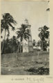 |
Venus Pt. light | P0013 Herbert E. Gregory Photograph Collection | P0013n13_080_9-3106 |
| 199 |
 |
View across old outflow channel of Silver Lake | P0013 Herbert E. Gregory Photograph Collection | P0013n08_182_1698 |
| 200 |
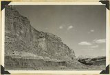 |
View down Fremont Gorge, in Capitol Reef. Left: Moenkopi, Chinle shales, talus slope and cliffs of Wingate. Right: Fruita, river terraces, cliffs of Wingate and high bumps of Navajo sandstone. Wayne County, Utah, 1937. | P0013 Herbert E. Gregory Photograph Collection | P0013n10_213_2473 |